On the morning of Tuesday, June 27, 2023, a rare occasion happened in my otherwise hectic summer schedule: both a weather window and a wide activation window opened!
As the French say, “Il faut en profiter!”
I always try to take advantage of any opportunities like this.
That morning, I checked in with my daughter, Geneva (K4TLI), to see if she might wish to do a SOTA activation. She was game, so I told her to grab her backpack.
My other daughter was at a one-week writer’s camp at UNC Asheville and my wife had other plans for the day, so it was also a great opportunity for some father/daughter time.
Oh, and another member of the family saw the hiking boots come out and immediately stopped what she was doing (tearing up a plush toy) to join us.
Hazel never, ever passes up a hike–! She gets more excited than anyone else in the family.
Mount Pisgah (W4C/CM-011)
We arrived at the trailhead of Mount Pisgah around 9:45 AM local.
There were much fewer hikers parked at the trailhead than I expected–then again, it was a Tuesday morning.
About thirty minutes into our hike we passed a couple who mentioned they’d spotted bears on the trail closer to the summit.
Not terribly surprising because (like my QTH) Pisgah is very much in bear territory. Since bears at this particular part of the parkway are used to human activity (and tourists feeding them), I pack bear spray. Those are the worst bears.
Black bears, in general, are fearful of humans and usually bolt the other way when they see you. Bears used to being fed by tourists are not and are known to get aggressive. I don’t take my chances.
In the latter part of the morning on Thursday, June 15, 2023, I hopped in my car and started the drive back to my QTH after spending a couple of days helping my parents in Catawba County, NC.
I had a window of about three hours where I knew I could fit in a POTA activation or two.
I’m quite familiar with POTA landscape along this particular corridor of western North Carolina, so I starting considering my options. I could have easily hit South Mountains State Park, Lake James State Park, and/or Table Rock Fish Hatchery, but what I really wanted to do was a little SOTA (Summits On The Air).
The problem, that particular day, was that the AQI (Air Quality Index) wasn’t great–not ideal for a strenuous hike, so I quickly dismissed that idea. The skies, in fact, were a bit hazy from the forest fire smoke blowing down from northern Canada.
Then it dawned on my that I could drive to the summit of Dogback Mountain (W4C/EM-066) and perform not only a SOTA activation, but a POTA two-fer as well since the activation zone is also in Pisgah National Forest (K-4510) and Pisgah Game Lands (K-6937).
In truth, I don’t do a lot of drive-up summit activations because, typically, when I want to do SOTA, I also want to hike. But drive-up summits are ideal on days like this when either weather is questionable, or the AQI is high.
The drive
If you live near western North Carolina, Dogback Mountain is a must. It’s one of the few sites I go to that I enjoy the drive as much as the activation.
As I mentioned in my previous Dogback field report, the road to the summit is a Forest Service road that has a very backcountry feel to it. It’s not maintained regularly, so you can expect washboarding, deep ruts, large exposed stones, deep potholes and wide mud holes.
This isn’t a road I’d recommend for someone driving a sedan or minivan (that said, many years ago I did take a minivan up this road–made for a dodgy drive). Your vehicle would benefit from some proper ground clearance and, ideally, all-wheel drive or four-wheel drive.
Frankly, I absolutely love driving this road because it’s passable most of the year, offers up amazing views, and has a number of dispersed camping spots (or POTA activation sites–!) along the way.
I drive backcountry roads routinely, so this is pure fun for me.
Dogback Mountain (W4C/EM-066)
The summit of Dogback Mountain is pretty much right on the forest service road. There are two pull-off parking areas on either side of the summit and both are well within the activation zone. In theory, you could set up your portable station along the road and do the SOTA activation there.
Note:Unlike POTA, the SOTA program does not allow mobile activations. If you activate a drive-up summit, you still need to set up a portable station that in no way uses your vehicle for support.
When I take a new radio to the field, I often don’t know what to expect until I arrive at the site and put it on the air. It’s one thing to use a radio in the shack, and quite another to use it in the field.
Earlier this year, I purchased a Venus SW-3B, three band QRP transceiver after much poking and prodding from readers and subscribers. I actually contacted Dale (BA4TB) at Venus and asked for a loaner to do a review, but he had no units set aside for loans, so instead offered me a coupon code. I was hesitant to purchase yet another QRP radio–which is why I asked for a loaner–but his coupon discounted the radio enough I could even afford to splurge for expedited shipping. He made money and I didn’t have to worry about loan periods, etc. It turned out to be a win/win.
I knew I wanted the SW-3B’s maiden voyage to be a SOTA summit, but I had to wait for a good weather window.
On Thursday, February 10, 2022, I got that opportunity!
Dogback Mountain (W4C/EM-066)
I learned about Dogback Mountain from my buddy Dave (W4JL) who activated it earlier this year. He told me it was a drive-up summit and was high enough to even rack up winter bonus points.
The road had no ice on it February 10, although it was very muddy and slippery in spots. Made for a very enjoyable drive in the Subaru, although post-activation you would have never guessed I’d washed the car the day before!
I arrived on site and parked the car at a pull-off that was well within the activation zone of the summit. Dave was right: this summit was very accessible (well, as long as your vehicle has a bit of clearance–this isn’t a road for sports cars or low sedans).
As mentioned in my last field report, on January 26, 2022, I decided to fit in multiple park activations in one day as a RaDAR (Rapid Deployment Amateur Radio) run. My hope was to activate four or five sites between 14:00 – 21:30 UTC.
The first activation at Lake James State Park went so well, it started me out a little ahead of schedule.
After packing up my gear at Lake James, I began a 40 minute drive to the second site–Dogback Mountain–where I hoped to do a POTA two-fer along with a Summits On The Air activation.
The drive was beautiful. Only twenty minutes into the trip, I came to the forest service road that lead to Dogback Mountain. For a six mile drive, Google Maps was telling me it would take about 20 minutes, so I knew the dirt road would require slow driving.
The road was actually in pretty good shape, but there are rocky and rough spots that pretty much require good vehicle ground clearance. My Subaru had no issues at all–in fact, I love driving on back roads like this!
Three or four miles into the forest service road I reached an impasse.
While there hadn’t been snow in the area for at least a week, the north slope portions of the road were quite icy. The thaw and night time freezing pretty much meant that there was no snow to navigate–only ice, and I’m not a big fan of ice.
I already passed through two sections of ice where I could still manage a little traction on the side of the road (at least half the car had traction). At one point, though, I saw a large section of icy road ahead, so I parked the car to investigate what it looked like over the crest of the hill.
It was so icy, I struggled to find a spot to walk on to peek over the hill and almost slipped once. That hill was pretty steep and I could see no spots for the car to get traction. Remembering what my wife said that morning (“Don’t do anything crazy, okay?“) and knowing that the worst thing for my RaDAR run would be getting stuck in a spot recovery vehicles might struggle with, I chose the option of forgoing the summit activation.
Frankly, if the summit activation was the only thing on the schedule that day, I would have likely parked, then hiked 3 miles to the summit along the forest service road. But my RaDAR run left no time for this.
Fortunately, where I parked was firmly in the two-fer zone of Pisgah National Forest and Pisgah Game Land!
Pisgah National Forest (K-4510) and Pisgah Game Land (K-6937)
I made a short post yesterday morning noting that I planned to take my Venus SW-3B and new field kit out on a maiden SOTA/POTA activation.
While I will be publishing a full activation report and video, it could be a good two weeks down the road.
I’ve gotten so many inquiries about the SW-3B, I thought I’d write up a short recap with some of my initial notes using the SW-3B in the field.
This isn’t a comprehensive review; just some beginning field notes I made for a full review I’ll write for The Spectrum Monitor magazine.
Dogback Mountain (W4C/EM-066)
I decided to activate Dogback Mountain knowing that it would easily fit in my travel plans. The views (see above) were extraordinary. Thank you for the tip, Dave (W4JL)!
This was also a shake-out for my Tom Bihn HTL2 field kit which will likely be shared with the SW-3B and Elecraft KX1. It includes everything I need to deploy the SW-3B in the field–including an arborist throw line!
I confirmed that everything in the kit worked and there were no missing components.
I paired the SW-3B with my PackTenna Mini 20 meter EFHW. This limited me to the 20 meter band, but I suspected it would yield enough contacts to validate my summit (4) and park activation (10).
I fed the Venus SW-3B with a 3 Ah 12V Bioenno LiFePo4 battery pack–my output power would’ve been about 5 watts.
Results
In short? It really couldn’t have gone better.
I worked a total of 43 stations in 44 minutes on the air. Here’s what my contacts look like on a QSO Map (click image to enlarge):
Venus SW-3B Field Notes
Overall, the experience of using the SW-3B was brilliant.
Since this little rig doesn’t have an internal speaker, I recorded the audio with an in-line Sony digital recorder. Later, when I produce the activation video, hopefully I can blend the separate audio channel with the video successfully. (Any YouTuber worth their salt can do this, but keep in mind I’m not really a YouTuber!)
SW-3B Pros:
Excellent receiver for field activations. I noticed no overloading and it handled the pileups very well.
Very pleased with CW filtering.
I was able to successfully program the “CQ” button with the following message: “BK TU 72 DE K4SWL” This is huge. At one point, the SW-3B could only handle a simple CW + callsign message. I’m very pleased its only message memory slot can hold the end of my exchange. Also, it is very easy to program.
The SW-3B is incredibly compact; only slightly bulkier than the MTR-3B if you include the encoder and AF/RF gain pot protrusions.
I am loving the dedicated AF and RF gain pots.
Display is very easy to read in the field.
SW-3B Cons:
Changing the CW keying sped on the fly is really not an option. It’s an awkward process.
The sidetone isn’t adjustable without modifying an internal component. If I could, I’d lower it just a notch or two. As-is, it’s perfectly fine, but adjustable sidetone would be a nice feature.
SW-3B Quirks:
When switching bands, the SW-3B defaults to saved memory allocations (not the last used frequency). If you forget and switch bands, then turn the encoder, it cycles through saves memory allocations instead of up/down tuning.
Summary
Keep in mind: this is my first activation with the SW-3B. I don’t typically form strong opinions until I’ve taken a radio on at least three or four activations and used it at the QTH extensively. With that said, first impressions are great. This radio offers much more than I would ever expect for $188.
I see why it has has become so incredibly popular among CW field activators. Now that the Mountain Topper MTR-3B is no longer available, this is a viable alternative.
I’m sure some of you may be trying to decide between the MTR-4B and the SW-3B. I will be reviewing an MTR-4B soon, but based on my experience with the MTR-3B, I don’t think you could go wrong with either radio, frankly.
The MTR-4B does allow for a total of 3 CW message memories that are very easy to access and include beacon mode. You can also adjust the sidetone volume on the MTR-4B (requires opening the enclosure to make the adjustment). Obviously, the MTR-4B is a four band radio including 80 meters in addition to 40, 30, and 20.
The SW-3B, however, has an AF and RF gain control–the MTR series has no volume control at all. The SW-3B also has a rotary encoder which makes chasing contacts across the band much easier.
The MTR-4B receiver current is roughly 27 milliamps. The Venus SW-3B closer to 40 milliamps. (Yeah, splitting hairs here!)
Stay tuned!
In the coming weeks, I will be posting a number of activation reports and videos using the SW-3B. As I mentioned, I’ll also post a comprehensive review for The Spectrum Monitor magazine in the coming months.
I can say this: if you’re a CW op who is searching for a compact field radio? The SW-3B is a no-brainer. Just grab one.
If you still can’t decide between the MTR-4B and the SW-3B, consider getting both. Why? You could easily kit out two independent fully self-contained field packs on the (relative) cheap!
This will give you two choices for grab-and-go field activations.
Thank you
As always, I’d like to send a special thanks to those of you who have been supporting the site and channel through Patreon and the Coffee Fund. While certainly not a requirement as my content will always be free, I truly appreciate the support.
Your support not only pays the bills at QRPer.com, but makes it possible for me to purchase radios like the SW-3B.
Thank you!
I hope you get an opportunity to play radio this week. Stay healthy and safe out there!
Recently on Twitter, I created an informal poll and asked if anyone else named their radios.
Here are the results:
I quickly found out that I’m in the 6.7% minority who freely admit that they name their radios.
We can also assume, however, that a healthy percentage of the “Neither confirm nor deny” crowd do too. They just have a professional reputation to maintain!
Truth is, I don’t name all of my radios; only the ones with “personality” that I plan to keep permanently.
Tuppence
My gift to myself after completing my very first CW activation in 2020 was to purchase a Mountain Topper MTR-3B from LnR Precision. I’ve always admired these tiny hiker-friendly transceivers and have watched as Steve Weber (KD1JV) updated the design over the years.
On Thursday, January 6, 2022, I woke up with one goal in mind: take the Xiegu X6100 out on a proper hike-in activation!
While I’d had this radio on loan from Radioddity since December 23rd, I hadn’t had an opportunity to truly hike it into an activation site. Between the weather and my tight schedule, I haven’t had an opportunity to plot out a proper Summits On The Air (SOTA) Activation. SOTA activations that involve hiking usually take a much bigger bite out of my day and, lately, I’ve been to busy to plot one.
I do live near a vast trail network, however, and it so happens that much of the trails run through overlapping public lands: Pisgah National Forest and Pisgah State Game Land.
So I packed my Spec-Ops EDC tactical pack, grabbed Hazel’s harness, and headed out the door.
Lately, I’ve had quite the backlog of reviews and evaluations building up. Family life has been active–and it always comes first–but also I’ve a number of projects on the table (two kit builds, one repair, two antenna projects), four articles for various publications, two new transceivers (the TX-500 and now an X5105 on loan), and a number of family business projects. ‘Tis the season, I reckon.
Normally, I’d be in Dayton, Ohio right now enjoying a weekend of fellowship and Hamvention/FDIM insanity, but all that was cancelled this year due to the pandemic.
I’ve had a number of projects that sort of force me indoors, but I haven’t felt like doing them. Spring in the mountains of western North Carolina is truly a thing to enjoy (save the allergies)–and it’s an incredible distraction.
On Saturday afternoon, May 8, 2021, my whole family wanted a little outdoor distraction time, so we hopped in the car and drove to a nearby spot in Pisgah National Forest.
The drive takes nearly 50 minutes even though the actual site isn’t even 5 miles from the QTH as the crow flies. The weather was beautiful, but a front was moving through bringing strong wind gusts.
I had planned to set up my activation next to our car along the forest service road, but to shelter myself from some of the winds, I decided instead to set up next to the nearby creek, down the hill a bit.
This particular site is actually located in both Pisgah National Forest and Pisgah Game Land–they overlap, which makes this a Parks On The Air “Two-Fer”.
While setting up next to a creek makes for a beautiful little activation spot, it also adds a lot of extra background noise. Normally, I would have used some in-ear earphones with the TX-500 for sound isolation, but (after twenty minutes on the air and against my better judgement) I decided to make an activation video at this site, so used the speaker/mic instead.
I’ve activated this site numerous times in the past and while it has tall trees and loads of spots to set up, it’s also in a pretty deep ravine, surrounded by tall ridge lines. While this is less a problem with HF as it would certainly be for line-of-site frequencies, history has proven that it makes for a challenging activation.
I deployed my new PackTenna 9:1 UNUN random wire antenna as a vertical. I’m glad I chose the PackTenna because it’s such a low-profile antenna, I knew it would be less affected by the strong wind gusts.
I also decided to employ my Emtech ZM-2 manual antenna tuner during this activation. Why? Because I had never used it with the PackTenna before. So why not?
On The Air
I hopped on 40 meters and started calling CQ. Thankfully, the Reverse Beacon Network found me and the POTA website automatically created a spot from the RBN information.
I worked four stations in four minutes! This was a much better start than I’d ever had at this site before.
Then, nothing…
About 20 minutes passed as I called CQ on 40 meters. This was going to be a challenging activation after all.
I decided to move up to the 30 meter band. I thought there might be some value in showing how to tune the ZM-2, so I started recording one of my real-time, real-life activation videos knowing that the audio might not be ideal with the rushing creek.
On 30 meters, I was able to pick up three more contacts in fairly short order, giving me a total of seven contacts. Only three more needed to validate my activation!
At least 20 minutes had passed since I was on 40 meters, so I decided to hop back down there hoping some new hunters might be monitoring the POTA spots.
Sure enough, I was able to add five more contacts in ten minutes!
My 12th contact is on the back of this log sheet: KF4YEY in FL.
I likely spent a total of one hour on the air. By the time it was over, my wife and daughters were ready to hit the road again: temps had dropped pretty quickly in that one hour time frame and the gusts were strong enough my wife was concerned it could knock some branches loose. (I was less concerned because I always check a site for widow-makers and power lines before setting up.
With such a simple radio kit, packing up was very quick.
This was my second activation with the new TX-500. I really do love this radio.
A number of folks noted in my last TX-500 video that there was an audio pop present as I keyed the radio either with my paddles or with the built-in memory keyer. I had never noticed this before, but I think I know why it’s happening. In my videos, I crank the speaker/mic volume up all the way so the audio can be heard. When I do this, the T/R relay audio pop/recovery is quite noticeable.
I think I may slow the relay recovery to something like 400ms so the audio doesn’t try recovering between characters. The TX-500 isn’t capable of full break-in QSK anyway, so there’s really no need for a 100ms recovery. I’ll also share this feedback with the engineers at lab599 as I suspect this can be sorted out in firmware. In the shack, it’s not an issue because audio levels are in the normal range, but in the field when the audio is cranked up, it’s pronounced. This also would not be an issue if using earphones, of course.
I do love this TX-500 and am very happy I’ve officially purchased it from lab599 and added it to my transceiver arsenal! Now to give it a name and make it official…
I’ll let you in on a little secret. Don’t tell anyone, but I held off making my first Summits On The Air (SOTA) activation until the stars aligned and I could activate one particular summit completely on foot from my QTH.
Last Thursday (February 25, 2021), my daughter and I hiked to Lane Pinnacle (W4C/CM-018) and performed my first Summits On The Air (SOTA) activation.
Why did I wait so long?
We live in the mountains of western North Carolina where (obviously) there are numerous SOTA summits to activate.
But I wanted Lane Pinnacle to be the first.
Why? Well, it’s the one summit I can hike to directly from my house with my daughter Geneva (K4TLI) and enjoy a proper father/daughter day hike.
I had planned to do this hike last year, but I injured my ankle and let’s just say that the hike to Pinnacle isn’t a beginner’s run. I knew my ankle would need to properly heal before the journey.
This is also more of a late fall to very early spring hike due to the amount of thick foliage we knew we would have to mitigate. It’s so much easier to keep your bearings when there are no leaves on the trees nor on the green briar!
Last Thursday, I felt confident that my ankle was up to the task. We had a break in the weather as well with moderate temps and lots of sunshine (this, after several days of rain). We knew things could be muddy and slippery, but we also knew that with my busy schedule this might be our last chance to hit the summit before the mountains green up.
So we packed a lunch, plenty of water, radio gear, and (of course) emergency/first-aid kits while trying to keep our backpacks as light as possible.
Hitting the trail!
The first part of the hike requires trailblazing to a ridge line. The distance is short, but the ascent is steep (about 800 feet). We hike this portion regularly, so knew how to pick our path and avoid the steeper, slippery bits.
K4TLI lead the way!
On the ridge line, we intersected an established single track trail and enjoyed the hike across a couple of smaller summits until we intersected the Blue Ridge Parkway.
If I’m being honest, I had some serious concerns that the trailhead to Lane Pinnacle would be closed. This portion of Blue Ridge Parkway is currently closed to motor vehicles (for the winter season) and I had noticed a number of “trail closed” signs on other portions of the parkway.
Guessing this may be a type of shelf fungus?
If the trail was closed, I planned to simply activate the parkway and Pisgah National Forest for the POTA program. I never hike on trails that have been closed by the park service because I like to obey the rules and I certainly don’t want to paint SOTA activators in a bad light.
When we crossed the parkway, we were incredibly pleased to see that the trailhead was open.
The ascent from the parkway to Lane Pinnacle is about 1,000 feet (305 meters) of elevation gain over a pretty short distance. The trail we were taking–turns out–was primitive. It basically lead us straight up the slope (no switch backs following lines of elevation, for example) and simply fizzled out about one third of the way up. We could tell it isn’t traveled often at all (although we did find a massive fresh bear track in the mud on the trail!).
Obligatory SOTA report “foot in snow” photo. 🙂
I bushwhacked our way to the top–at times, the slope was about 45 degrees and slippery, but we easily found our way to the summit where our goat path intersected the Mountains To Sea trail.
We found an amazing overlook and took in views of the Bee Tree Reservoir as we ate our lunches.
Geneva grabbed her dual-band HT and made the first summit contact with our friend, Vlado (N3CZ) on 2 meters FM.
On the Air
I knew there would be short trees on the summit of Lane Pinnacle, but I also knew that I wanted to get on the air as soon as possible to allow extra time for our hike home.
I did pack a super compact wire antenna, but opted instead for the Chameleon CHA MPAS Lite vertical. I paired it with my Elecraft KX2.
The great thing about the CHA MPAS Lite is how quick it is to deploy–it might have taken me all of three minutes.
Since it was noon, I decided to start on the 20 meter band. I found a clear frequency, started calling “CQ SOTA” with the KX2 memory keyer, and spotted myself to the SOTA network via the excellent SOTA Goat app on my phone.
I had also scheduled my activation on the POTA website in advance because Lane Pinnacle is in Pisgah National Forest (K-4510). My buddies Mike (K8RAT) and Eric (WD8RIF) were also helping to spot me in the unlikely event I wouldn’t have cell phone service on the summit.
Within 20 seconds of submitting the spot to the SOTA network I had a CW pileup.
In all of my hundreds of field activations, I can’t think of a single time that I generated a CW pileup on 20 meters in such short order with five watts and a vertical.
The first station I logged was N1AIA in Maine. The second station was F4WBN in France. The race was on!
It took every bit of CW skill I had to pull apart the stations on 20 meters. It was so much fun!
I eventually worked Spain and all of the west coast states (WA, OR, and CA) and numerous stations throughout the Rockies and Midwest.
I then moved to 40 meters where I worked stations in the Mid-Atlantic, Ohio Valley, and in the Southeast.
In the end, I had to keep my total time on the air short because I wanted to take my time finding a path from the summit back down to the Blue Ridge Parkway.
In 30 minutes I worked 30 stations. I’m not a seasoned CW operator, so this was quite the accomplishment.
Here’s a QSOmap of my contacts:
I was chuffed! What a fabulous activation to kick off my SOTA adventures.
Video
This time, I did not make a video of the actual activation. For one thing, I didn’t want to carry a folding tripod for the camera and I didn’t want to ask my daughter to film it either. I wanted to keep things as simple as possible to make the most of the airtime I had.
I did, however, make a short video before and after. You can check it out on my YouTube channel:
Hiking home
I really wish we could have stayed on the summit for an hour longer making contacts, but I knew it would be wise to allow extra time to descend Lane Pinnacle especially since I knew a front was moving through later that day.
I decided it would be easier to do my own bushwhacking back down the mountain rather than try to retrace our previous steps. We took our time and I followed elevation lines to make it slightly less steep. Since I took a more south westerly descent, when we reached the parkway, we had to hike north to reach the original trailhead.
The rest of the hike was totally uneventful and incredibly fun. The weather held and we took in the views, the wildlife, and invaluable father/daughter time.
That was the first strenuous hike I had done in months due to my ankle, so let’s just say I was feeling “spent” after our 6.5 hour adventure taking in 2,000 feet (610 meters) of elevation to the summit.
I knew it was bad when I even dreaded walking upstairs to take a shower. I think I remember telling my wife, “I’m never building a house with stairs again!”
More SOTA!
Now that I’ve got Lane Pinnacle in the books, I’m ready to start hitting the summits! I’ve got a lot of pent up SOTA energy!
My goal is to activate a total of ten this year. That may sound like a modest number, but since at this point I’m less interested in “drive-up” summits, it’s more difficult to fit SOTA summits into my schedule than, say, typical POTA/WWFF parks.
In fact, I’ve already plotted my next SOTA activation and hope to do it within the next couple of weeks. It’s also a meaningful (to me) summit.
How about you?
Are you a SOTA activator or are you planning your first SOTA activation soon? Please comment!
On Wednesday, October, 14 2020, the weather was gorgeous so I decided to make an impromptu POTA activation of Pisgah National Forest and the Pisgah Game Land (K-4510 and K-6937). These sites are the closest to my QTH and only a 15 minute drive (in fact, I can even hike up to the same trail network from my back yard).
My canine companion, Hazel, jumped into the car before I could even invite her to come along.
We drove to the trailhead, parked, and hiked a short distance into one of my favorite spots where it’s relatively flat, with lots of tall trees and almost no foot traffic from other hikers.
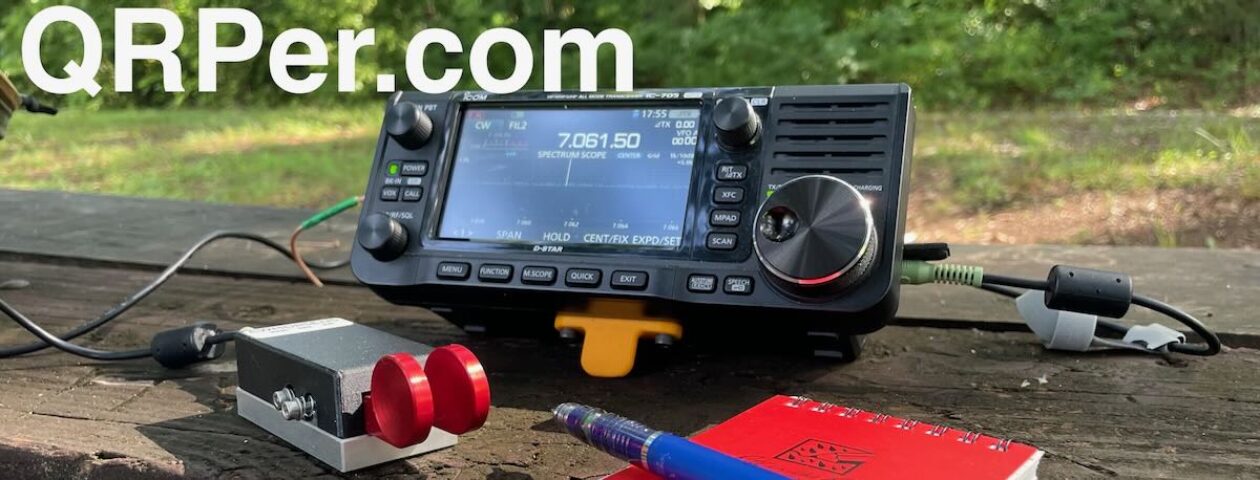
This activation gave me an opportunity to use the Icom IC-705 in more of a “backpack” setting since I hiked in with only my pack, Hazel, and my folding three-leg stool. Up to this point, I’d only used the IC-705 on picnic tables and flat surfaces since it can’t easily fit on my clip board like my MTR-3B, KX2, and KX1 can.
The activation also gave me a chance to evaluate a new product sent to me by the CW Morse company: their “Pocket Paddle” designed specifically for portable operations.
I decided to set up the Icom IC-705 much like I did the lab599 Discover TX-500 when I took it on hikes: mount the radio above the front pocket of my Red Oxx C-Ruck backpack.
The arrangement works quite well–I simply sit on the stool in front of the pack and hold my simple logging notepad and paddles on a clipboard.
While this particular site is great because it’s so accessible to me, the negative is it’s deep down in a valley surrounded by high ridge lines. I feel like this does have some impact on how well my signal travels.
Wednesday, it took nearly 50 minutes to rack up a total of 12 contacts in CW mode. I never bothered with SSB/phone because this site had no cell phone service and, thus, there was no way to spot myself on the POTA network.
That’s okay, I felt pretty chuffed about racking up 12 contacts with 5 watts and a wire! This is what field radio is all about, in my opinion.
After a little falling out with the mAT-705, I decided I wanted to try other ATUs with the IC-705. I used to own an Elecraft T1 ATU and loved it, but I eventually sold it for a song to a friend since all of my field rigs at that point had internal ATUs.
I reached out to Elecraft and they sent me a T1 on loan to give it a go. I’d forgotten how much I love this simple, effective ATU.
Even though the EFT-MTR is resonant on 40, 30, and 20 meters, moving to the 30 meter band requires lowering the antenna, pulling off an SMA cap on the coil, then re-hanging it. Not a big deal at all, really, but it’s so much easier to simply press the tune button on the T1 and have it match 30 meters without going through the normal process.
CW Morse Pocket Paddle
I also thoroughly enjoyed using the CW Morse “Pocket Paddles.” I’m not sure when they’ll be available to purchase (perhaps they are already?) but I can highly recommend them.
The paddle action is field-adjustable and even though there’s an Allen wrench built into the paddle base, the machined screws are easy to twist by hand.
They feel very sturdy, too, much like the other CW Morse paddles and keys I’ve used.
I believe the Pocket Paddles are going to permanently pack with my IC-705!
QRP radios, product announcements, reviews, news and more. Low power amateur radio fun!
Please support QRPer by adding us to your whitelist in your ad blocker. Ads are what helps us stay online. All of our ads are ham radio related--no junk, we promise! Thank you!
 On the morning of Tuesday, June 27, 2023, a rare occasion happened in my otherwise hectic summer schedule: both a weather window and a wide activation window opened!
 We arrived at the trailhead of Mount Pisgah around 9:45 AM local.


