
On Tuesday morning, May 14, 2024, I hopped in my car and headed north to Athens, Ohio. It was in Athens, back in 1997, that my ham radio journey truly began, and where I met my friends Eric (WD8RIF) and Mike (K8RAT).
For over 14 years, Eric, his son Miles (KD8KNC), and I have made the annual pilgrimage to Hamvention and FDIM, with few interruptions. My routine is to drive to Athens, catch up with Eric and his wife, Vickie, stay overnight, and then head to Dayton the next day with Eric and Miles. I enjoy this because it breaks up my travels and usually allows for some POTA activating along the way.
This Wednesday morning, Eric had an appointment and a meeting, so our plan was to leave for Dayton around noon. This gave me the morning free to play radio!
Breakfast at Miller’s Chicken
I left the house around 8:00 AM with the goal of activating Strouds Run State Park, conveniently located near downtown Athens. But first, breakfast!
I try to avoid chain restaurants when traveling, preferring local spots. I was delighted to discover that Miller’s Chicken, an Athens institution, served breakfast. I had no idea!
Miller’s Chicken holds fond memories for me. When my wife was a graduate student at Ohio University, for a brief period of time, she lived within walking distance and we often ate there. She even acted in a student film shot at the restaurant!
 Walking in, I realized it had been 23+ years since my last visit. I ordered a bacon, egg, and cheese biscuit with coffee as a group of students left, leaving me with the place almost to myself.

POTA at Strouds Run State Park (US-1994)
 I arrived at the park around 9:15 AM. It had been raining all morning, so I sought cover under a picnic Shelter. Eric, a frequent activator of Strouds Run, had told me where to find all of Strouds’ shelters.
Check out Eric’s standing on the park’s POTA page:
 You can also read all of Eric’s hundreds of field reports on his website.
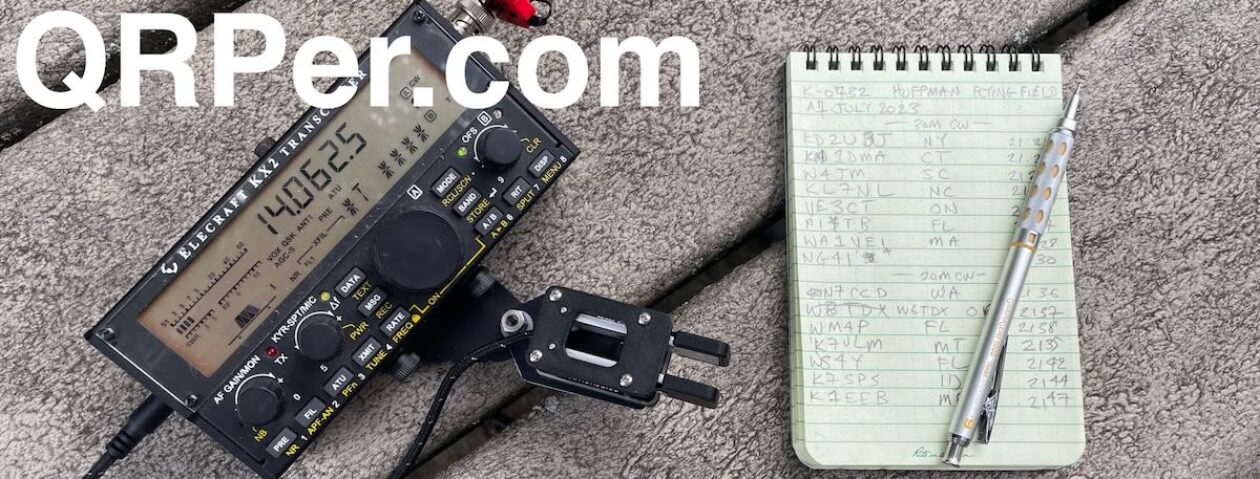
 I found an empty shelter by the lakeshore (no surprise given the weather). I brought several radios with me on the Dayton trip: my Elecraft KX2, KH1, Index Labs QRP Plus, Venus SW-3B (always in the car), and my Yaesu FT-818.
Propagation has been a hot mess lately. I figured 40 meters and 20 meters would be the best bands to try, and the EFHW is resonant on both, eliminating the need for an antenna tuner.
 Setup was easy, with trees near the shelter providing ideal suspension points for the EFHW.
(Note about audio: As I prepared this activation video, I discovered that my wireless mic wasn’t connected, so you won’t hear me when I walk away from the camera. My apologies! There’s also more wind noise than usual. However, you’ll hear plenty of waterfowl and other birds enjoying the park.)
Jeweler’s Bench Block
 Only a couple of days prior, I received a Jeweler’s Bench Block that I purchased on Amazon.com (affiliate link). Several friends had recommended I pick up one to pair with my lightweight, portable keys that have embedded rare-earth magnets.
The key I paired with it was my BamaKey TP-III. You’ll hear me rave about this combo in the activation video.
It weighs 13.7 ounces and has a silicon base: I found that with the TP-III (which has a light action), it was rock-solid on the picnic table.
I wish I would have purchased one of these ages ago!
Gear:
 Note: All Amazon, CW Morse, ABR, Chelegance, eBay, and Radioddity links are affiliate links that support QRPer.com at no cost to you.
- Yaesu FT-818ND
- WINDCAMP 3000mAh LIPO battery for FT-818/817
- WINDCAMP Anderson PowerPole Adapter for FT817/818
- High Visibility Jacket ABR240-UF with PL-259s and 5 Ferrites (Use Coupon Code ABR10QRPER for 10% Discount!)
- SO-239 to BNC Adapter
- MM0OPX QRP EFHW (Contact Colin for Availability)
- Key cable: Cable Matters 2-Pack Gold-Plated Retractable Aux Cable – 2.5 Feet
- BaMaKeY TP-III Ultra-Compact Twin Paddle
- Jeweler’s Bench Block (Weighted Key Base)
- GoRuck GR1 USA
- Weaver arborist throw line/weight and storage bag
- GraphGear 0.9mm 1000 Automatic Drafting Pencil
- Rite In The Rain Top Spiral Notebook
- Portable Zero FT-817 Side Rails and Bail
- Camera: DJI OSMO 4 action camera with Joby Telepod Sport Tripod
- DJI Wireless Microphones
On The Air
 I started calling CQ and, fortunately, hunters started replying! Continue reading POTA Activation at Strouds Run State Park: A Rainy Morning and Ham Radio Memories!


