Tag Archives: Guest Posts

Matt’s Weekend POTA Roundup!

Many thanks to Matt (W6CSN) who shares the following post from his blog at W6CSN.Blog:


Weekend POTA Roundup

by Matt (W6CSN)

It’s been a stormy past several days here in Northern California, but if anything, the weather only amplifies my motivation to go outside and get on the air.

Rather than do a separate writeup for each, this post is a roundup of my last four POTA activations, from Friday, February 2nd through Sunday, the 4th.

A faint rainbow splashes down in front of Angel Island

Thursday and Friday had been wet, with one storm in a series moving across the Bay Area. However, by Friday evening the cold front had passed and there was a break in the rain. This was a perfect opportunity to try an after work activation at the Presidio of SF (K-7889).

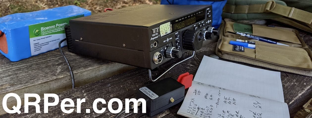
I hadn’t used the QCX-Mini in a while, and this activation reminded me why. I believe what is happening is that being so close to the antenna, RF interference causes clicking while keying, nearly to the point of distraction. I need to experiment with RF chokes on the key and audio lines to see if that improves the situation.

Fed up with the RFI on the QCX-Mini, I switched over to the MTR-4B which doesn’t seem to suffer the same issue. I wrapped up the activation after netting 21 QSOs in the cold west wind.

All QSO maps in this post are from http://tools.adventureradio.de/analyzer/

The next bout of rain wasn’t due to arrive until later Saturday afternoon. This was a change in the forecast that subsequently altered my plan to stay in Saturday soldering on my QMX Hi-Bander project.

Initially I went to Fort Point (K-0819) in the hopes of changing it up from my usual activation park but there were just too many people there. So seeking relief from crowds, I crossed the Golden Gate Bridge and went up on the slopes of Mt. Tamalpais.

I parked at Trojan Point at an elevation of approximately 1800 feet. See this post for more views from this location. The temperature was in the mid-40s, which is cold for us coastal Californians. Besides, the winds were picking up ahead of the next storm so I operated from the comfort of my vehicle using the Gabil 7350T base loaded vertical antenna on 15m and 20m.

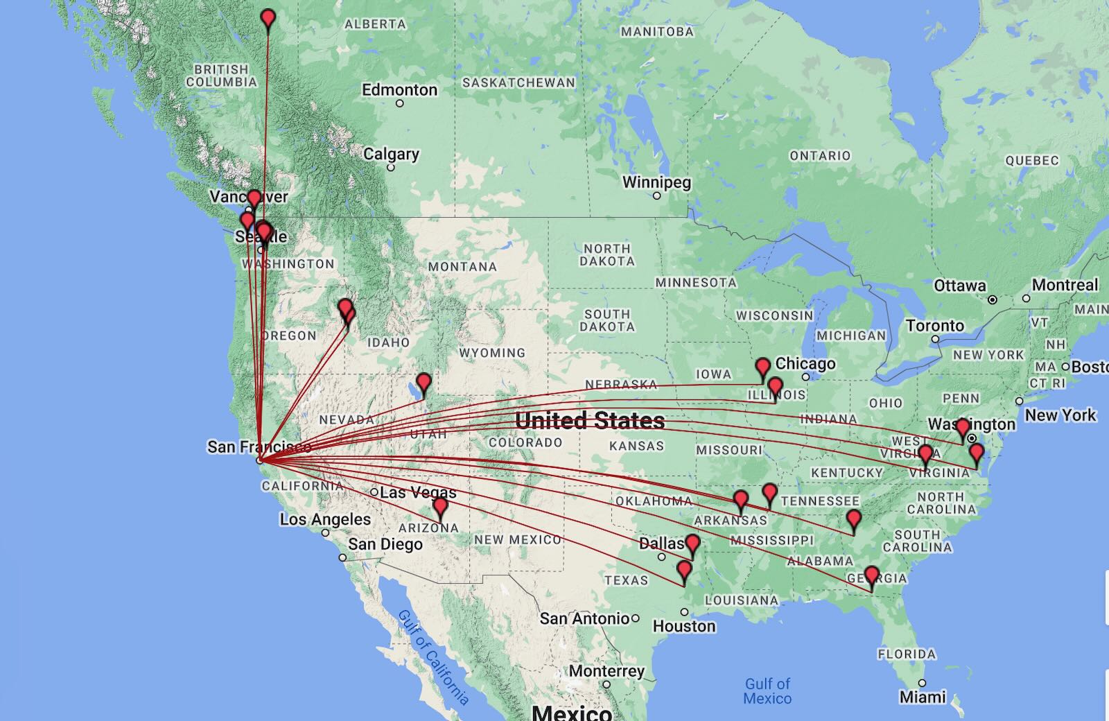
This activation used the FT-818 and yielded 23 contacts, including JH1MXV from northwest of Tokyo, Japan coming in fairly strong on 21 MHz.

Driving back to San Francisco takes me right through the Presidio of SF (K-7889) and noticing that it was after 00:00 UTC, I made the last second decision to divert to East Beach to see if I could work in another activation before the anticipated rain.

At my usual spot for activating this park, it took only moments to raise the MFJ-1979 20m quarter wave and do a quick deployment of the MTR-4B on the trunk of the car. The wind was picking up, but not nearly as strong as it was up on the mountain.

After seven QSOs, the skies began spitting raindrops, this was going to be close! I closed the cover of the Maxpedition pouch to protect the radio and battery while the Bencher paddles could tolerate a little bit of moisture.

I was happy to have a Rite-In-The-Rain notepad for logging [Amazon affiliate link], because now I was certainly writing in the rain! Three more contacts and the activation was concluded with a hunt of Jim, WB0RLJ, in K-4011. Continue reading Matt’s Weekend POTA Roundup!

A Hasty Activation in Georgia

by Teri (KO4WFP)

As many of you know, my personal life has been tumultuous these past five months. I thought maybe it would settle down after the first of this year but no such luck. My son and I moved into a townhouse the third week of January. While I appreciate my parents upending their lives to accommodate the two of us during my divorce, there were too many people in too small of a house with too much stuff. Also, my son needed a room of his own which he didn’t have at their place.

Moves are never convenient and this one was no exception. I needed to be packing the Sunday prior to my early Monday morning move. However, I had already committed to and scheduled an activation at Oliver Bridge Wildlife Management Area (K-3764). The weekend of January 20th and 21st was the winter Support Your Parks weekend and, as a POTA Babe, there was no way I would miss the event!

Support Your Parks information on POTA website

Thankfully, Oliver Bridge Wildlife Management Area (WMA) is only 40 minutes from my parents’ home. That meant another pleasant drive in rural Georgia on GA Route 17 through the communities of Guyton, Egypt, and Oliver.

Google Maps

This WMA consists of 1,560 acres and offers hunting for deer, small game, and turkey. Checking the Georgia Department of Natural Resources Hunting Regulations guide, the only item in season this particular weekend was small game. I would make sure to take the blaze orange vests for both Daisy and me again.

The WMA is bounded on one side by the Ogeechee River, one of the few free-flowing streams in Georgia. This blackwater river runs southeast 294 miles to empty into the Atlantic Ocean at Ossabaw Sound near Savannah. It played an important part for trade and commerce as well as was a source of freshwater and food for communities along its banks. In present day, kayaking and canoeing are popular pastimes on the river as well as fishing.

https://gisgeography.com/georgia-lakes-rivers-map/

Daisy and I arrived at the WMA a little before 11 AM. We took River Road in the park to find a place for the activation. The road was in rough condition in some spots and was another one I’d not want to drive immediately after a heavy rain. I was thankful, once again, for my four-wheel drive Subaru Crosstrek nicknamed Kai. (My family has a funny habit of naming all our cars.)

On the map, there appeared to be a clearing about two-thirds of the way down the road. Tall, skinny pine trees lined either side of the road, not great for getting an arborist line into them. Thankfully, the canopy opened up for a small clearing as I surmised from the map and it was here I decided to set up.

Because of the opening, the pine trees near the side of the road had some lower, reachable branches on them. After a few tries, I snagged the branch I wanted and began hoisting the Tufteln EFRW antenna with the arborist line.

In past activations, I would usually get the antenna up however I could. But, at this point in my POTA journey, I am beginning to think how I want the antenna oriented with propagation in mind. I wanted it to run at a diagonal – northwest to southeast. To do that, I’d have to get it across a wide ditch that was partially frozen due to the cold temps. However, if I just tossed the line across, it was light enough it would likely end up in the ditch where I couldn’t easily retrieve it. Continue reading A Hasty Activation in Georgia

W7UDT: “Velcro, ergo; ergonomics…”

Many thanks to Rand (W7UDT) who shares the following guest post:


Velcro, ergo; ergonomics…

by Rand (W7UDT)

Velcro is amazing. It’s so handy. There are so many uses, and creative solutions it provides us. It’ll stick this to that, and that to this. As field operators, it should be part of our kits.

Below are some examples of how I’ve used Velcro.

Question: How do you keep a Android tablet, a 3aH 12v DC pack, a QRP Labs QDX LoBander, all its cords & patches, plus an EmTech ZM2 tuner all nice and tidy? Velcro!

Here’s the old QDX kit…

Here’s the new (velcro’d) QDX kit, complete with EmTech ZM2 tuner, neatly attached on the back of the Tablet, with the QDX and DC Pack. It all fits in a zippered pouch, along with the EFλ/2 antenna, perfect for the QDX.

The new QDX kit even sits at a nice viewing angle, with all of the cords hidden from view. Ergo, ergonomics.

Question: Where & how do you safely place your transceiver on a rugged SOTA/POTA activation, so it won’t get damaged?

How? Velcro! What makes more sense? A precarious rock, or the Molle patch on your pack?

This is my QCX Mini ~ Forty, Velcro’d with two horizontally applied 1” strips, with short cords channeled between them. It secures the perfectly mated 3aH 12v TalentCell battery, to which I applied another velcro strip to hold fast the Palm Pico paddle. Also note the ‘D-shaped’ earpiece/speaker, on the BNC jack. It’s hung and velcro’d just above the paddle.

Since this photo, I’ve added three 2×4” (cut to fit) patches to the front, back and bottom of the QCX Mini & TalentCell, which neatly bundles this little QRP contraption and transforms it into a QRP wonder! Now it all fits in my hand, or attaches firmly to my pack. Dit dit dit daw! Velcro!

A view from Zion NP, in the backcountry… late last Spring. Where my little transceiver tried to commit suicide.

Just sayin’… Velcro may be just the answer you’re looking for.

72 de W7UDT ID (dit dit)

Braving the Polar Vortex at Yuchi WMA

by Teri (KO4WFP)

It has been two and half weeks since the final activation of my winter-break Florida POTA trip. Despite a polar vortex dumping frigid weather into Georgia, I was determined to activate and continue working on my 60 new-to-me park activations goal for 2024.

Google Maps

About an hour and a half from my home QTH is Yuchi Wildlife Management Area (K-3778). The property is managed by the Georgia Department of Wildlife Resources and located next to the Savannah River, the border between the states of Georgia and South Carolina. The site consists mostly of pine uplands and hardwoods with some acreage of openings for wildlife. One can hunt for deer, turkey, small game, and doves as well as utilize the public shooting range located on the property.

Given the time of year, I pulled out my copy of the GA Department of Natural Resources (DNR) Hunting Regulations booklet to see what might be in season right now. Looking at the specific regulations for Yuchi Wildlife Management Area (WMA), only dove season might be an issue while I activated the park. Just to make sure, I contacted the appropriate DNR office and spoke with a helpful employee. He assured me I was not likely run into anyone hunting on a weekday for doves or small game. Of course, Daisy and I would wear blaze orange just to be careful when outside the car.

My time for an activation was tight given my previous commitment as a K3Y/4 operator for the Straight Key Century Club the same afternoon. However, if I got an early enough start, I could make it work.

Daisy and I left the house around 7:30 AM with a quick stop at Lowe’s. I really didn’t want to sit outside in the chilly temperatures; it was 26 degrees according to the weather app. The stop at Lowe’s was to take advantage of an idea generated by a comment from John KK4ITX, an idea I hoped would keep me warm in the car during my activation.

The drive to Yuchi WMA was pleasant. I enjoy driving in rural Georgia. This particular drive went through the towns of Oliver, in which I found another diminutive and cute U.S. Post Office, and Sylvania. Sylvania had that typical small-town feel. I snapped pics of the two murals I saw, something I look for and often find in these communities.

Daisy and I finally arrived at the WMA about one and a half hours after departing Bloomingdale. Before we reached the site, its neighbor, Plant Vogtle, revealed itself.

The plant is a four-unit nuclear power plant managed primarily by Georgia Power. The first two units went online in the late 1980s. Units three and four were the first nuclear units in the United States approved since 2016. Unit Three is operational and Unit Four is supposed to be up and running this year. When all four units are operational, Plant Vogtle will be the largest nuclear power plant in the United States.

Daisy and I found one of the open dirt roads on the property and begin our search for a suitable QTH. Thankfully my Subaru Crosstrek has four-wheel drive as there were soft spots on the road. I wouldn’t want to drive here after a heavy rain.

We drove past plantings of pine as well as areas of hardwoods. After rounding a corner and driving up a slight incline, a wider opening in the canopy appeared. On one side next to a planted pine field, there were several taller deciduous trees now devoid of foliage. It looked to me like a perfect QTH for today’s activation with abundant sunshine. Continue reading Braving the Polar Vortex at Yuchi WMA

The Final Fling in Florida

by Teri (KO4WFP)

It is Sunday, December 31st, the final day of 2023 and, coincidentally, my winter-break Florida POTA trip. Time to return home. But, as I promised at the end of my last article, the journey is not yet done. A POTA Babe is not going to squander the opportunity to fit in another activation or two on the way home.

Google Maps

Joseph and I loaded up the car one final time after our stay at an Airbnb in Umatilla. I found two parks at which to attempt activations – Lake George State Forest (K-4627) and Pellicer Creek State Conservation Area (K-8367). I chose Lake George because I had yet to activate a state forest and Pellicer because of its proximity to Interstate 95, my route back home.

Lake George State Forest is named (unironically) for Lake George, the second largest lake in Florida. The forest is formed from lands previously used for timber, production of naval stores, cattle grazing, and hunting. It consists of over 20,000 acres of land that offer trails for hiking, cycling, and horseback riding as well as access to hunting, fishing, and birding.

I was unclear as to where to easily access Lake George State Forest. We found the Dexter/Mary Farms Tract entrance at which is a checkpoint for hunters. I learned I needed to purchase a pass before accessing the property and could do so via an off-hours phone number. I really didn’t want to set up shop in proximity to hunting, partially because it seemed like a bad idea (duh) but also I didn’t bring my blaze orange vest on the trip.

We learned of another entrance for the forest and headed that direction. Along the way, we ran into the Barberville Yard Art Emporium who billed itself as offering the largest variety of unique handcrafted outdoor art. I believe it judging from what I saw. Anyone for a giant chicken?

After gawking at the sculptures, we headed to the Fawn Road entrance for Lake George State Forest. This entrance looked more like what I expected.

My brother Joseph donned his bright orange rain poncho and headed up the road for a hike. I, on the other hand, looked for a place to set up and get on the air. I’d need to stick to the road as it was flooded on both sides and I didn’t bring the footwear to tromp through water. Most of the trees were very tall pines. I didn’t think I could get a line on their lowest branches.

Thankfully, I found a few trees of lower height. Once the Tufteln EFRW was installed and my station set up in the road (it was closed to vehicular traffic), I commenced my activation.  I ran later than my original estimated start time but the RBN still picked me up.

As usual, I was tight on time. In 30 minutes, I had 20 contacts on 20 meters. Two days ago, I had a contact from Etor F6VMN in France. I figured why not hop onto 17 meters to see if he would hear me again today. Guess what? He did hear me and we logged another contact. The band gave me nine contacts in 10 minutes for a total of 29 contacts at this park.

QSO Map for Lake George State Park http://tools.adventureradio.de/analyzer/

By this time, Joseph had returned from his hike. We packed up and were off to our next destination – Pellicer Creek State Conservation Area. Continue reading The Final Fling in Florida

More Surprises in Florida

by Teri (KO4WFP)

It is Friday, December 29th and my winter-break POTA trip is drawing to a close. My brother Joseph and I are spending Friday and Saturday nights at an Airbnb after six days of camping. However, before we do that, I have two more parks to activate today – Green Swamp Wilderness Preserve (K-5330) and Lake Apopka North Shore (K-8353).

Google Maps

Overnight, a cold front began its march through Florida. We woke to temperatures in the low 50’s and a brief glimpse of the rising sun before clouds took over the sky again.

The drive to our first park – Green Swamp Wilderness Preserve – was a pleasant one. The preserve is divided into five management districts. We ended up in the West Tract as that is what I chose in Apple Maps. There are 65 miles of hiking trails though the tract is also used for hunting, canoeing, fishing, camping, and equestrian activities. There is a variety of habitats in the preserve – sandhills, flatwoods, oak hammocks, river swamp, and cypress ponds.

I chose an oak tree just inside the West Tract entrance perfect for the Tufteln EFRW antenna. A sunny location was necessary as the temperature was chilly in the breezy conditions. As I set up, two ladies rode in with their horses. Salty, a red roan, was unsure of Daisy and I at first. However, he eventually settled down enough to walk by and check out my POTA flag. Being a horse owner previously, I have a soft spot for these intelligent and sensitive creatures.

Salty and his owner

When Salty moseyed on, Daisy and I got down to business. I went straight to 20 meters which had no noise at all. In 35 minutes, I had 20 contacts. I needed to wrap up the activation soon to have sufficient time to fit in the second activation today but thought I’d check 17 meters for any DX contacts. I had four contacts on that band including Etor FH4MN in France!

QSO Map for Green Swamp Wilderness Preserve http://tools.adventureradio.de/analyzer/

In short order, I packed up my equipment and we headed to Lake Apopka with a stop at Costco for gas. On the drive, we saw five sandhill cranes. I had heard sandhill cranes at Little Manatee River State Park while walking Daisy one day. But I never spied them. These cranes were wary of me and the pictures I snapped weren’t great.

We finally arrived at Lake Apopka North Shore which features an 11-mile wildlife drive. The park reminded me of the Savannah National Wildlife Refuge back home in which I’ve spent some time. Lake Apopka is the headwaters of the Ocklawaha Chain of Lakes. The North Shore area consists of former farmlands that are now used to clean up Lake Apopka’s waters by circulating the lake water through restored wetlands thereby filtering it before it is returned to the lake. Those former farmlands polluted the lake with phosphorous which caused a host of problems. Continue reading More Surprises in Florida

Scott’s Self-Supporting Random Wire Antenna System

Many thanks to Scott (KK4Z) who shares the following post from his blog KK4Z.com:


K4SWL+ Antenna

by Scott (KK4Z)

On a recent post on QRPER.com, Teri KO4WFP was at a park in Florida that did not allow wires (or anything else) in their trees. Many POTA activators use End Fed Half Wave antennas which usually require one end in a tree. While it doesn’t happen at all parks, not being able to hoist your antenna could bust an activation.

I realized this may happen to me even though Georgia appears to be pretty lenient when it comes to such matters, I decided to switch to a park friendly antenna. I have been a fan of QRPER.com for quite some time and occasionally Thomas will repost something from my humble blog. That being said, it was K4SWL that got me started using a random wire antenna. My basis for my antenna was his speaker wire antenna which was a 28.5’ vertical antenna with a 17’ counterpoise. I used it a few times in that configuration and then started to modify it. I call this antenna my K4SWL+.

Some of the differences are I use a push-up pole to get the antenna in the air and at the base I use a 9:1 UnUn and a 1:1 Choke to keep RF out of the radio. A random wire antenna can feed RF back into the coax.

The wire is 14 ga. coated flex weave from The Wireman. This was left over wire from some other antenna projects. When I started this project I was using 22-24 ga. coated wire from SOTABeams but realizing there was no need to save weight, used the heavier wire. This allows me to dual purpose the antenna both for FunComm and EmComm. The insulator at the top is 3D printed with my call-sign and the base is U-type lugs. I find these are the best as I do not have to take the nut off of the antenna studs and if pulled hard will come loose instead of damaging the UnUn. I connect the antenna to the top of the push-up pole with a small Nite-eze “S-biner” size 1.

The 9:1 UnUn comes from Palomar Engineering. I have already created a blog post about how to build it and it can be found here: https://kk4z.com/2022/05/28/91-unun-qro/

Part of this blog post was to bring the different components together into one blog post.

The 1:1 Choke can be found here: https://kk4z.com/2022/08/15/lightweight-choke-balun/

I made two different types but I found the second works much better.

The project is pretty easy, the only caveat is to pay attention to what wire goes where. Putting it all together, you need a push-up pole, a Flag holder and maybe a trailer hitch extender. I will provide links below. The Flag Pole holder I used was not available so the link I used is a probable substitute. I have a trailer hitch on both my truck and my camper, When I pull into a campsite I have a choice of which hitch to use to keep my antenna clear from the trees. With the antenna up, I wrap the antenna wire around the push-up pole from tip to base, to prevent the wire from sagging near the tip. I attach the UnUn and choke to the mast with Stretch Velcro Straps. With my antenna up I have park employees drive by me all day along. Most of the time we exchange a friendly wave and occasionally one will stop by for a chat. I have had zero issues with this antenna at any of the parks I have visited.

How does it play? It has pretty much been a main antenna for just about all of my POTA activations. You can go back through my blog post and see what equipment I used with the antenna and the accompanying QSOMap. You do need an antenna tuner with this antenna and I typically use an LDG Z-11 Pro which I’ve had for 15+ years. The antenna tunes up from 80 to 6 meters and I have run the power as high as 65 watts. I normally run 10-35 watts depending on band conditions. I have tried it on 160 meters and while I can get a match, I don’t think much RF is leaving the antenna. I’ve made a few contact with it on 160. If you like to work 160 meters during a POTA activation, I suggest a Chameleon EmComm II with a 60’ antenna and a 50’ counterpoise. I run it as an inverted L with the apex about 20’ up my push-up pole and the end sloping down to something not a tree. Last time I tied it to the lantern stand at the campsite. It worked pretty well and I was able to make contacts on 160.

Video:

Click here to view on YouTube.

If you’re looking for an antenna that you can set up almost anywhere, with little or no hassles, take a look at this one. Don’t forget to check out the short video above. 73 — Scott

The Fun Continues at Alafia River State Park

by Teri (KO4WFP)

It is Thursday, December 28th, the fifth day during my winter-break Florida POTA trip. The day began way too early. The rain was forecast to be a steady downpour where we camped. We woke at 3:30 AM to the light pitter-patter of rain on the tent fly and decided to get on the road before conditions worsened. Before heading to bed, we had put the bulk of our stuff already in the car. It wasn’t long before we had everything packed and were headed north.

Google Maps

I’ll admit it is an obsessive compulsive behavior that I like everything neatly organized. Because it was raining while we decamped, I had hurriedly bundled up the tent & fly and dumped them into the back of the car. That wet tent sitting back there really bothered me. About twenty minutes up the road, I found a shopping center with a covered area just begging to be used to repack that tent neatly as I desired. Now we could resume our trek northward.

Due to the early hour of our departure, we arrived at Alafia River State Park (K-1829) much earlier than time for check-ins. We found our tent site and while driving by, noted the two individuals in it were attempting to do what we did at 3:30 AM. We twiddled our thumbs in the car until 10 AM, grabbed our check-in tag, and headed to our site. Though it was still drizzling a bit, the tent was up and we were installed soon after checking in.

The rain was the harbinger of a cold front headed through Florida. With no sun to warm us, we bundled into our sleeping bags and Daisy into hers and fell asleep for an hour or so.

As I traveled through Florida, I asked myself, “Are there any of these parks to which I’d return?” Alafia River State Park is one for which I’d say “Yes.”

Alafia River State Park is a former phosphate mine, particularly for pebble phosphate.  Because phosphate is found relatively close to the surface in the state, Florida is a leader in phosphate mining.  The mining at Alafia River State Park created the topography making the park an awesome mountain biking destination with 17 miles of trails from beginner to advanced. The park also offers hiking and equestrian trails.

The campground in this park was the nicest we’d encountered. The sites were well spaced apart and, if so inclined, one could even glamp at this park. The bathrooms were sufficient though from our site, we had to walk the furthest to reach them. However, having that little bit of exercise was good for us and the walk pleasant. The park felt so open because of the topography but the high grasses characteristic of the area also gave the landscape a sense of privacy. The park was not crowded like other locations we had visited. Continue reading The Fun Continues at Alafia River State Park

An Awesome Day for Parks On The Air

by Teri (KO4WFP)

It is Wednesday, December 27th, the fourth day of my winter-break Florida POTA trip. The night before, we left the rainfly off the tent and were treated to a gorgeous view of the waxing gibbous moon. My brother Joseph was delighted and, while I worked on my article for that day, he lay back on his new Thermarest sleeping pad and took in the night sky.

Full moon through tent top: Collier-Seminole Photo by Joseph Leffek

I opted to sleep in until 8 AM enjoying the cooler morning air. Then it was time to get a shower and rid myself of four days of grunge. Breakfast was a leisurely affair. The mosquitos were less prevalent so I let Daisy relax on the tarp next to us and watch the comings and goings of our neighbors. But by 11 AM, I was getting antsy – time to head out and attempt two activations.

Google Maps

We drove east on the Tamiami Trail/US Highway 41 heading toward Big Cypress National Preserve (K-0659). The road is straight with guardrails on both sides as there is either wetlands or a canal on either side of it.  Occasionally there is a break in the foliage and the mangroves come into view.

Bird life is abundant in the area. We saw egrets, wood storks, cormorants, anhingas, and, my favorite bird, kingfishers. At my previous QTH in Savannah, I heard kingfishers at times but rarely saw them. On this drive, I saw eight or nine perched on the utility wires beside the road and gleefully noted each one.

We stopped at the Nathaniel P. Reed Visitor Center to pick up a map and figure out a place for my activation.

Big Cypress National Preserve Visitor Center

I chose the H.P. Williams Roadside Park as it was the closest place to the visitor center and had the opportunity for wildlife viewing. The parking lot was crowded and it was easy to see why. The site has a boardwalk from which one can view alligators and a nice picnic area in which several families ate lunch.

I found a tree away from the crowd and set-up the Tufteln EFRW. In the process of doing so, a little girl came up and peppered me with questions. Then her father and sister joined us. As soon as I was set up, I let them hear my callsign as well as the two girls’ names in Morse Code. It was nice to share my love of the hobby as well as Daisy, on whom they lavished some attention. What I think was a yellow-rumped warbler also paid Daisy and I a visit during the activation. Continue reading An Awesome Day for Parks On The Air

More of the Unexpected at Collier-Seminole State Park

by Teri (KO4WFP)

It was Tuesday, December 26th, the third day of my winter-break Florida POTA trip. As my brother Joseph and I were moving at a leisurely pace this morning, I decided to work in a quick activation at the campsite as the antenna was already in the trees from the prior night’s activation.

Even though this second activation at Little Manatee River wouldn’t count toward my 2024 goal, it was still a valid activation. POTA is like eating potato chips – You can’t do just one! I had five QSOs on 40 meters to begin and then 14 on 20 meters before calling QRT. We needed to get on the road and head south.

QSO Map for Little Manatee River SP Day Activation http://tools.adventureradio.de/analyzer/

My brother desperately needed a new Thermarest as the old one he brought on the trip was not working for his back. He had always wanted to visit an REI store. We found one in Sarasota-Springs and stopped by. He found a better sleeping pad and I found a few items I needed to add to my arsenal – a small brush for cleaning sand off items, a camp pillow so I didn’t have to lug my pillow from home in the future, more bug-repellant wipes, and a smaller quick-dry towel. Happy with our purchases, we resumed our journey southward.

We had lollygagged enough in the morning there wasn’t sufficient time for an activation on our way to the next camping destination – Collier-Seminole State Park (K-1847). The drive was nearly all interstate and not that exciting. It never ceases to amaze me how many people live in Florida!

Google Maps

Collier-Seminole State Park is located in southern Florida as you head toward the Big Cypress Wildlife Management Area and Everglades National Park. The Big Cypress Swamp was the last refuge of the Seminole Indians. Collier-Seminole State Park lies along the Tamiami Trail, a road from Tampa to Miami that was constructed in the early 1900’s and runs through the Big Cypress Swamp. An advertising mogul Baron Collier (for whom Collier County and Collier-Seminole State Park are named) was a significant investor in the Tamiami Trail and, in fact, bankrolled the completion of the east-west portion of the road.

After you enter Collier-Seminole State Park, on the right is the last existing Bay City Walking Dredge. This dredge was used to build the Tamiami Trail and would follow drilling and blasting rigs. The dredge dug a canal which provided rock fill for roadbed drainage of the completed road. It is a unique and huge piece of equipment.

Some parks are easier to activate than others. This was not one of the those. My first hint should have been when I was asked to read the rules when checking in. The first rule is nothing in the trees. I mentioned I am a ham radio operator and asked if it be ok to put an antenna up with an arborist line that won’t damage the tree. That request was met with an immediate and emphatic “No!” Rules are rules and, as I brought my hitch mount and SOTABeams mast on the trip, I could work around that restriction.

I planned to set up my antenna and get on the air in the comfort of my tent as I had at the previous park – Little Manatee River State Park. However, running right in front of our site and all through the campground were power poles. This campground was also much larger than our previous one. I wasn’t sure how much RFI I might get from the surrounding RVs and power lines as we appeared to be the only tent at this site. Continue reading More of the Unexpected at Collier-Seminole State Park