On Monday, October, 18, 2021, I finished a few errands in Asheville, NC and realized I had just enough time to squeeze in an afternoon activation. The weather was beautiful, the fall air felt amazing, and although I had no clue what propagation was like, I needed some field radio therapy!
Blue Ridge Parkway to the rescue!
I’ve mentioned in previous videos that pretty much anytime I drive into Asheville I pass by the Blue Ridge Parkway. Over the years, I’ve discovered numerous POTA (Parks On The Air) spots scattered along “America’s Favorite Drive.”
It’s fall, so we’ve autumn leaf colors and loads of tourists in the region–especially on the BRP.
Even so, I’ve one favorite overlook that is often overlooked by tourist!
It’s a little unofficial turn-out on the parkway that offers up spectacular views. I believe the reason tourists pass by it is because it’s located just beyond one of the most popular overlooks in the area: the Tanbark Ridge Overview. Tourists stop at Tanbark to enjoy the views not knowing that a mere +/-200 meters away, there’s one they could enjoy all on their own. Continue reading Field Report: POTA Roadside activation with a view!→
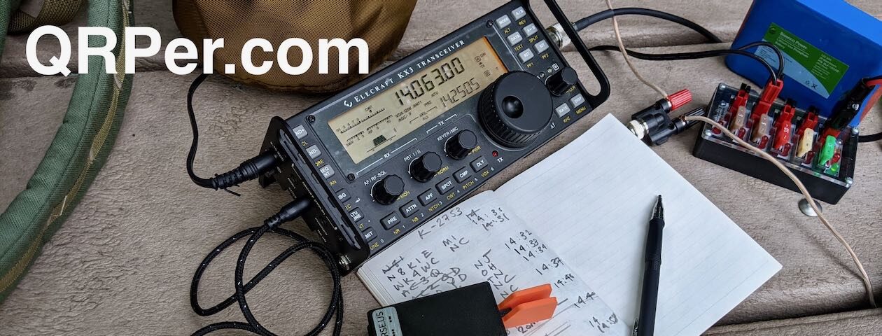
On the morning of Thursday, September 23, 2021, I had one thing on my mind: SOTA!
It had been well over a month since my last SOTA activation and I was eager to hike to a summit and play radio.
It had been raining for a few days but overnight, a front moved into the area that swept out all of the clouds. We were finally feeling proper fall weather.
It was gorgeous outside and I made up my mind I’d fit in a summit activation.
I was visiting my parents in Hickory, NC, so I knew I’d have to drive a bit to activate a unique (to me) summit. On top of that, I knew I’d be alone and trails would be very muddy after days of rain. I decided to stick with an easy hike, so picked Flat Top Mountain (W4C/EM-026) off of the Blue Ridge Parkway.
I announced my activation via the SOTA website and drove about one hour to the trailhead of Flat Top Mountain.
Aborted!
As I drove up US321 to Blowing Rock I noticed that clouds were hangin over the mountains. In the foothills, it was blissful: clear skies, sunshine, dry air, and quite cool. As I drove up the Blue Ridge escarpment, it started getting a little gusty outside–I realized that the mountains were still on the edge of the cold front. Continue reading SOTA Plan B: An aborted activation followed by an amazing (although gusty) alternative!→
The Blue Ridge Parkway is one of the easiest POTA sites for me to activate when I’m at the QTH.
Pretty much anytime I head into Asheville from home, I’m going to cross the parkway. The BRP is such a refuge, I often take it to avoid hitting the Interstate or a busy highways. It takes longer, but it’s orders of magnitude more peaceful and pleasant than, say, Interstate 40.
On Monday, September 13, 2021, I had a small opening in my schedule in the afternoon and decided to pop by the Folk Art Center for a quick picnic table activation since I was passing by.
The Folk Art Center is a site where I typically deploy smaller, lower-profile antennas to keep from interfering with others who are enjoying the park. I try to keep my antennas very close to my operating spot and my counterpoises on the ground in a space where others aren’t likely to tread.
In the past, I’ve used the Wolf River Coils TIA, the Elecraft AX1, Chameleon MPAS Lite & MPAS 2.0, and once, a Packtenna 9:1 UNUN random wire. I avoid anything that slopes so that I don’t inadvertently “clothesline” unsuspecting vacationers!
After completing a successful activation at Fort Dobbs State Historic Site on Wednesday, August 25, 2021, I decided to fit in one more activation that day. I thought about heading out to one of the game lands I hadn’t hit in a while, but frankly, I needed a park a little closer to home due to my time constraints that day, so Lake Norman State Park it was!
Lake Norman State Park (K-2740)
Lake Norman is such an effortless park to activate. Their main picnic area has numerous tables (including two large covered areas), and tall trees providing support for antennas and much needed shade from the NC summer sun!
One thing I had not decided upon was what antenna I’d use at Lake Norman. Earlier, I used my trusty speaker wire antenna at Fort Dobbs, but I like to shake things up. I checked the trunk of my car and found the Chameleon MPAS Lite. Seeing how propagation plummeted after my previous activation, I decided that I wanted a large wire antenna deployed rather than a vertical.
The MPAS Lite can be configured as a wire antenna, of course: instead of attaching the 17′ whip to the “Hybrid Micro” transformer, you attach the 60′ wire that might normally be used as a counterpoise.
Setting it up was quite easy, in fact. I used my arborist throw line to snag a tree branch about 45′ high, then attached the throw line to the floating dielectric ring on the Chameleon wire spool. I stretched the entire length of wire out, attached the end to a tree, then hoisted up the center, forming an inverted vee shape.
Wire antennas are so low-profile and simply disappear in trees.
Even thought the 50′ coax shield would act as a counterpoise, I really wanted another ground wire attached, so I pulled one of the wires off of my speaker wire antenna and attached it to the grounding post of the MPAS Lite’s stainless spike. I figured a little extra counterpoise wouldn’t hurt.
Although I’d never used the CHA MPAS Lite quite like this, I was pretty confident my Elecraft T1 would find a match. The Chameleon transformer (the Hybrid Micro) brings most any (but not all) lengths of wire within reasonable matching range of an ATU.
I started on 40 meters and found that, without employing the ATU, I had a match that was slightly below 2:1. Not terribly surprising since I had a good 60′ of wire in the tree. Still, I hit the tune button on the T1 and easily achieved a 1:1 match.
I will add here, though, that perfect 1:1 matches are not that important–especially at QRP levels. I’m certain the TX-500 would plug along with a match of 2.5:1 or higher and still radiate perfectly fine. I’ve known hams that truly equate that 1:1 match with an antenna that’s performing efficiently, but that’s not always the case. Keep in mind a dummy load will give you a 1:1 match but is hardly efficient. The ATU’s job isn’t to make the antenna radiate better–it’s to match impedance.
The CHA MPAS Lite will get you within matching range across the HF bands and, many times, it’s close enough that an ATU isn’t really needed.
I started calling CQ POTA on 40 meters and within 28 minutes had logged the ten contacts needed for a valid park activation–all with 5 watts, of course. I was very pleased with these results because, as I had suspected, the bands were still pretty darn rough.
I then moved up to the 30 meter band where I worked a couple of stations and then, for fun, found a match on 80 meters and worked one NC station (possibly on ground wave!).
Here’s a screenshot of my logs from the POTA website:
I must say that I do love using the Discovery TX-500. It’s such a brilliant little field radio. I’m just itching to take it on another SOTA activation soon!
I’m also loving the TX-500 field kit that I built around a Red Oxx Micro Manager pack.
I used the same bag (different color) for my KX2 NPOTA field kit in 2016. It’s such a great size and can even easily hold my arborist throw line along with all of the station accessories and rig, of course. I’ve made a short video showing how I pack it and will upload that video when I have a little bandwidth!
Video
I did make a real-time, no-edit video of my entire Lake Norman activation. Feel free to check it out below or via this YouTube link. No need to worry about ads popping up–my videos have no YouTube ads!
A Brief Public Service Announcement…
If I have a little advice for you this week, it’s this: don’t wait to play radio because someone says you don’t have the right gear for the job.
I received an email this morning from a ham that’s new to field operation and just received an antenna he had ordered. He was upset because a YouTuber claimed his antenna was basically a dummy load. To add insult to injury, he also found a blogger or YouTuber was also highly critical of his recently-acquired Yaesu FT-818. [Note that the FT-817ND–the 818’s predecessor–is one of my favorite field rigs.]
Keep in mind that many of these YouTubers are trying to produce “click bait” videos that will stir up a reaction and, thus, increase their readership numbers which will have a direct and positive impact on their ad revenue. It’s a red flag when someone doesn’t have real-world examples and comparisons proving their points and typically a sign that they’ve never even used the products in question.
I’ve been told antennas I use don’t work, yet I’ve snagged some incredible QRP DX with them. I’ve been told that some radios I use are junk, yet I’ve hundreds of successful field activations with them. And funniest of all are those who tell me that QRP is ineffective and–quoting from an actual message recently–“a complete waste of time.”
My advice is to simply ignore these folks. The proof is in the pudding! Get out there and play radio! In the words of Admiral Farragut, “Damn the torpedoes. Full speed ahead!”
Thank you!
As always, thank you for reading this field report and a special thanks to those of you who are supporting the site and channel through Patreon and the Coffee Fund. While certainly not a requirement–my content is always free–I really appreciate the support.
Here in the Asheville, NC area, there’s one mountain that almost anyone can recognize by sight: Mount Pisgah.
Mount Pisgah is prominent because not only is it one of the taller summits bordering the Asheville basin, but it’s also home to the WLOS TV tower and and a cluster of public service and amateur radio repeaters.
I’ve been eager to activate Mount Pisgah for Summits On The Air (SOTA). Along with Bearwallow Mountain, and Mount Mitchell, it’s one of the most popular SOTA summits in the Asheville area.
Being so accessible from the BRP, the Mount Pisgah trail also receives a heavy amount of foot traffic. Being locals, our family tends to skip this trail when we’re venturing along the BRP because it can be so congested at times.
Mount Pisgah (W4C/CM-011)
On Tuesday, June 1, 2021, Hazel and I decided to hit Mount Pisgah fairly early and avoid the crowds.
We arrived at the trailhead around 8:15 AM and there were very few cars there–a good sign indeed!
Hazel was chomping at the bit to start our hike!
The trail is only about 1.5 miles with a 700 foot elevation gain, so not strenuous.
It was blissfully quiet and we only passed two other groups of hikers on the way up.
I’ll admit that I was keeping an eye out for black bears, though. We saw bears very close to the trailhead entrance on the BRP that morning. I may have mentioned before that black bears are not something to be feared here in western North Carolina; they typically avoid people and your chances of being fatally injured by a black bear are incredibly slim–right there with being struck by lightening.Still, the black bears that wonder near populated spots like Pisgah along the parkway are often fed by tourists and lose their fear of humans. Not only that, but they even expect people to be food dispensers. Not good. As we say around here, “a fed bear is a dead bear” because feeding bears leads to aggressive behavior and the poor creature’s eventual euthanization.
But I digress!
Hazel and I reached the summit and were happy to find that we were alone. Pisgah’s summit can get very crowded as there really isn’t a lot of space–only a large viewing platform next to the massive tower.
When we arrived on site, the summit was surrounded in clouds.
I briefly considered operating from the viewing platform, but knew I would have to cope with a lot of curious hikers while trying to operate CW. Since I’m not a good multitasker, I decided to do what many SOTA activators do: carefully pass under the tower and find an activation spot on the other side of the summit.
Hazel and I found a small overgrown trail used primarily by those working on the tower. I deployed my station in a small clearing.
For this activation, I chose my Elecraft KX2 and paired it with the Chameleon CHA MPAS Lite which has quickly become one of my favorite SOTA antennas.
I deployed the CHA MPAS Lite perhaps 15 feet away from my operating spot, in the middle of a spur trail. I was able to extend the 17′ vertical without touching any branches. I rolled out about 20-25′ of counterpoise wire along the ground.
After setting up, it dawned on me that I’d forgotten my clipboard. No worries, though! I simply flipped over my GoRuck GR1 pack and used the back as an operating surface.
On The Air
Not only was this a summit activation, but also a park activation–indeed, a two-fer park activation at that! The summit of Mount Pisgah is in both Pisgah National Forest (K-4510) and Pisgah State Game Land (K-6937).
If I’m being honest here–since I’m not a “numbers guy” and don’t follow my activation counts closely each year–it’s very tempting not to announce or count this activation in both the SOTA and POTA programs since K-4510 and K-6937 aren’t rare entities. The main reason for this is because, back home, I end up doing double entry with my logs: loading them via the SOTA online log submission tool, then entering them in N3FJP or TQSL for submission to the POTA and WWFF programs. It can be very time-consuming doing this.
I am working on a way to “massage” the ADIF file data so that I can submit it to both programs with less effort.
But, of course, I announced the activation on both SOTAwatch and the POTA site. At the end of the day, I’ve never *not* announced a dual SOTA and POTA activation because I can’t help but think it might offer up the sites to a new POTA hunter. It’s worth the extra log entry later.
Another plus with activating a site in two programs is that you’ll likely be spotted in both thus increasing your odds of logging the necessary contacts to validate your activations.
Turns out, snagging valid activations that Tuesday morning was incredibly easy. And fun!
Fabulous conditions!
I started on 20 meters CW and logged fifteen stations in eighteen minutes. The band was energized because not only did I easily work stations from France, Slovenia, and Spain in Europe, but also stations all over North America from the west coast to as close as the Ohio valley and into Canada.
I wanted to play a little SSB, so I moved to the phone portion of 20 meters and spotted myself on the SOTA network. I worked five stations in eight minutes. Fun!
Next, I moved up to the 17 meter band and stayed in SSB mode. I worked five more stations in nine minutes. Had I only activated this site in SSB on 20 and 17 meters, I could have obtained both a valid SOTA and POTA activation in 17 minutes.
Even though I knew I needed to pack up soon, I decided to hit the CW portion of 17 meters before signing off. I started calling CQ and was rewarded with sixteen additional stations in eighteen minutes.
Phenomenal!
All in all, I logged 41 stations.
Here’s the QSO Map of my my contacts–green polylines are CW contacts, red are SSB (click to enlarge):
A welcome interruption!
If you watch my activation video, you’ll note that as I moved to the 17 meter band and started calling CQ, another hiker popped in and introduced himself.
Turns out it was Steve (WD4CFN).
As Steve was setting up his own SOTA activation on Mount Pisgah next to the observation deck, his wife, Patty, heard my voice off in the distance giving a signal report.
Steve and I had a quick chat and coordinated frequencies so we wouldn’t be on the same band at the same time and interfere with each other.
After finishing my activation, I stopped by the observation deck and spent some time with Steve and Patty as Steve finished his SOTA activation and packed up his gear.
Steve was also using an Elecraft KX2 and strapped his telescoping fiber glass mast to the side of the observation deck to support a wire antenna. Very effective!
Hazel and I hiked back to the trailhead with Steve and Patty. It was so much fun talking ham radio, QRP and SOTA with kindred spirits. What an amazing couple!
Steve and Patty were actually on a multi-day camping trip in WNC and planned to hit two more summits by end of day. In fact, I got back to the QTH *just* in time to work Steve (ground wave!) at his second summit of the day. It was fun hunting someone I had just spent time with on a summit!
Steve and Patty: Again, it was a pleasure to meet you both!
Hazel and I both needed a little trail time that Tuesday morning. Hiking to the summit in the low clouds, taking in the views, enjoying a stellar activation and then meeting new friends? It doesn’t get any better than this.
I’ll say that I do love the Elecraft KX2 and CHA MPAS Lite combo. It makes for a compact and effective SOTA pairing that can be deployed so quickly.
A couple months ago, I ordered a SOTAbeams Tactical Mini fiberglass telescoping pole. I plan to pair it with my QRPguys tri-bander kit antenna.
If I’m being honest, though, I find that the CHA MPAS Lite is so quick to deploy–like 2-3 minutes tops–I’ve yet to take the Tactical Mini and Tri-Bander to a summit. No worries, though, as I will eventually deploy this pair on a summit. Admittedly, I need to work on my mast guying skills in advance–let’s just say that I’m still in that awkward stage of struggling to manage each guy line as I try to keep the Tacmini vertical during deployment. I welcome any tips!
I’ve been receiving a lot of comments lately from readers and viewers asking to see more Hazel in my reports and videos.
Hazel, if you’re not familiar, is my brown, white, and freckled canine shadow.
Hazel requires absolutely no prep time to go on a hike and summit/park activation. She’ll go from a deep, dreamy sleep where she’s chasing squirrels and her paws are twitching, to wide awake, tail wagging and nose pointed at the door in 2 seconds flat.
All it takes is the sound of me putting on my hiking boots (which must be louder that I imagined).
On Monday (May, 24, 2021) the weather was beautiful and I decided to finally add Bearwallow Mountain to my list of SOTA activations. Hazel was ready for a short hike!
Bearwallow Mountain (W4C/CM-068)
Bearwallow is one of the most popular summits to activate in the Asheville/Hendersonville area of western North Carolina. Any semi-seasoned local SOTA activator probably has Bearwallow in the logs. Why?
The Bearwallow antenna farm is extensive!
For one thing, Bearwallow is a ham-friendly site. A number of local repeaters are on this mountain and some of our local clubs have access to the summit. Once–I can’t remember the year–I even spent time with a club (I believe it was the Roadshow ARC) on Bearwallow for the ARRL Field Day. It was a blast!
Bearwallow is also a very accessible summit.
The trailhead to the summit (Google Map) is tucked away in the Upper Hickory Nut Gorge area–and there’s ample paved parking unless you happen to pick a very busy day (basically, any weekend with good weather will be busy!). Hazel and I were hiking on a Monday morning, thus there was very little activity and loads of parking spaces.
Some years ago, Conserving Carolina acquired the summit and much of the land on Bearwallow Mountain. Their conservation easement protects this area from future development and opens it for the public to enjoy.
Conserving Carolina maintains the trail system to the summit and all of the hiker information and blazing.They do a brilliant job!
There are two options for hiking to the summit: a proper foot trail, or you can take the Fire Tower Road which is the best choice for hikers who need a more gentle incline and flat gravel hiking surface.
Hazel and I found a nice spot to set up the station well within the activation zone. On summits like Bearwallow where there are clusters of communications towers, I prefer not to set up next to them. This is where that 25 meter SOTA activation zone (AZ) comes in handy.
I had actually planned to use my Elecraft KX3 on this activation, but after setting it up, I realized quickly that my power cord had developed a fault.
Fortunately, I packed a spare radio.
Knowing in advance that this would be a short hike–before leaving the QTH–I also packed the KX2 kit in my backpack as a backup. I don’t always have the luxury of packing a second radio, but wow! Am I glad I did that Monday!
Setting up the Chameleon CHA MPAS Lite vertical, of course, was super easy.
On the Air
I started the activation on 20 meters and spotted myself to the SOTA network via the SOTA Goat app. Of course, before leaving home, I had also set up an alert on SOTAwatch so that the spots page would auto-spot me via the Reverse Beacon Network (RBN) if I didn’t have mobile phone coverage.
In short? The contacts started rolling in. I was very surprised to have this sort of response on a Monday morning.
In 22 minutes, I worked a total of 19 stations including one summit to summit (S2S)–thanks for that, Eric (VA2EO)!
I was very pleased with the number of contacts logged in such short order because I only had a max of 25-30 minutes to be on the air before I needed to pack up and head back to the QTH.
Here’s the full log:
Activations like this one remind me of what one can do with QRP power and a modest antenna.
Sure, at one point–after I had worked at least my first four to achieve a valid QRP SOTA activation–I increased the power from 5 watts to a cloud-scorching 10 watts!
I must apologize for the audio in this one–it’s a little weak due to how the camera was set up.
Hazel at it again
So I brought along a retractable leash/lead for Hazel for this particular outing.
This leash allows her to roam more freely during our actual hike. On the summit, I locked the leash and attached it to my pack so it would keep her within 4 feet or so of where I was sitting which was cow patty-free.
At one point, near the end of the activation, when I was trying to manage a few calls, off-camera Hazel discovered that the leash unlocked, allowing her more flexibility to roam.
I looked up to discover that she found a semi-moist cow patty I somehow missed and was preparing to “enjoy” it. While sending CW and trying to keep from knocking down the camera, I used my left foot to put the brakes on her leash. She knew I was struggling, though, and tugged more.
I managed to stop her before even one paw plopped in the patty. Somehow. It was a very close call, though.
If you’ve watched my activation videos before, you’ve no doubt gathered that I’m not a multitasker. This little event really tested my ability to hold it all together on and off camera!
After packing up the station, Hazel and I took the Fire Tower Road back to the car. It was a very pleasant stroll and cow patty free.
Thank you for coming along with me on this SOTA activation and making it to the end of the report. You deserve an award! Please treat yourself to a local summit or park soon!
On Monday, March 22, 2021, I performed three QRP field activations in one day. I started off the day with a visit to Three Top Mountain Game Land, and then headed to Mount Jefferson State Natural Area for a POTA and SOTA activation before heading to New River State Park.
When plotting my multi-site activation day, I picked Mount Jefferson because it’s a SOTA entity (W4C/EM-021). I only realized later that it’s also a POTA entity (K-3846). I mistakenly assumed Mount Jefferson was a county park rather than an NC state park. To do both a POTA and SOTA activation simultaneously is ideal!
Mount Jefferson (W4C/EM-021)
This was my first visit to Mount Jefferson and, frankly, I wasn’t sure what to expect in terms of hiking.
The park itself is amazing! North Carolina parks never let me down.
The entrance is near the base of the mountain and very close to the town of West Jefferson. The park road climbs up the side of Mount Jefferson –there are a number of spots to park, hike, and picnic.
I had not checked the trail map in advance, but I had read that the summit trail was accessible from the parking and picnic area at the end (top) of the park road.
I hopped out of my car, grabbed my SOTA pack, and very quickly found the trail head.
The trail is impeccably maintained and wide enough for vehicle use (no doubt these trails double as access for tower maintenance on the summit).
The hike to the summit from the parking are was incredibly short–about .3 miles. Normally, I’d want a much longer hike, but since I was trying to fit three site activations in a span of four hours, I didn’t complain.
On top of the summit, one is greeted by a typical cluster of transmission towers.
While I appreciate checking out antennas and towers, these are never a welcome site because they can generate serious QRM, making a SOTA activation difficult.
I also found a park weather station on the summit. Nice!
I searched around and found a spot to set up well within the activation zone but giving me a bit of distance from the towers.
My Yaesu FT-817ND was desperate to get a little SOTA action, so I decided to pair it with the Chameleon CHA MPAS Lite using the Elecraft T1 ATU to find matches.
After putting the FT-817 on the air, I was very pleased to hear that the nearby transmission towers and power lines weren’t causing any noticeable interference. This was a very good sign because, frankly, propagation was very unstable that day and I had real concerns about being able to work stations on 40 meters.
I hopped on the air and quickly realized I’d forgotten to hook my external battery up to the Yaesu FT-817ND. This meant I was running something closer to 2.5 watts as opposed to a full 5 watts. I decided to attempt the activation without the external battery and add it if needed.
I started operating on 20 meters and was very pleased to quickly rack up a number of contacts. I could tell that most of these contacts were via SOTA because I recognized the calls and primarily SOTA chasers.
Within 11 minutes, I worked 10 stations on 20 meters in CW. I was very pleased with how quickly those QSOs rolled in and how easily I logged the four needed for a valid SOTA and 10 needed for POTA activation–all on 20 meters.
Next, I moved to 40 meters where I worked two stations and 30 meters where I worked one. For sure, 20 meters was a much stronger band than 40 and 30 turned out to be.
After working 13 stations, I packed up.
Obviously, 2.5 watts was plenty for this activation!
I would have loved to stay longer, but frankly, I needed to stick to my schedule because I had one more park to fit in that day! (More on that in a future post and video!).
Here’s my QSOmap for the Mount Jefferson activation:
And here’s my full log:
Video
Even though I was a bit pressed for time, I still made one of my real-time, real-life videos of the entire activation. I hope you enjoy:
Next up will be an activation of New River State Park. I hope to post this early next week.
Last Tuesday (March 2, 2021), I needed to make a quick trip to south Asheville and pick up some gear I had ordered from REI. Of course, I had a hankering to fit in a Parks On The Air activation. I contacted my buddies Eric (WD8RIF) and Mike (K8RAT) and mentioned I might make a visit to the Blue Ridge Parkway [it’s always a good idea to have others look for you in case your unable to spot yourself on the bands].
By the time I jumped in the car, though, I talked myself out of doing the activation. Propagation was poor and I had a maximum of 30 minutes to fit in a valid activation.
After picking up my gear at REI, I realized, though, that a 30 minute limit made for an awfully fun challenge.
I had to pass by the parkway to go home, so why not? Right?
I did a quick check and, yes(!) I had the Elecraft KX2 and CHA MPAS Lite antenna in the car.
Before leaving REI, I scheduled my activation on the POTA website so that the site would know to auto-spot me if the Reverse Beacon Network picked me up.
Blue Ridge Parkway (K-3378)
I arrived at the parkway in very short order. I decided to do the activation at the Blue Ridge Parkway Visitor’s Center and Headquarters. Normally, I avoid this location because it’s busy and the best spots to set up a radio are in the path of visitors walking around the perimeter of the grounds.
It was a cold, overcast Tuesday morning so, as I expected, I almost had the place to myself.
I deployed the CHA MPAS Lite vertical in very short order–perhaps 3 minutes. Since I had also packed my Pixel 3 camera/phone and tripod in the car, I even recorded a video of the full activation (see below).
In short? I snagged my 10 contacts in about 19 minutes on the air–all on 40 meters CW. Not too bad for a Tuesday morning with five watts and a vertical.
Here’s a QSOmap of the contacts I made:
I also had a first at this activation! I worked ND9M/MM. To my knowledge, I’ve never worked a maritime mobile station at a park activation–certainly not in CW! The map above omits this contact since the location was unknown.
When I submitted my log to Bill DeLoach (our regional contact for POTA logs) said I really need a “Wham Bam!” award for this quick activation. Ha ha!
I’ll let you in on a little secret. Don’t tell anyone, but I held off making my first Summits On The Air (SOTA) activation until the stars aligned and I could activate one particular summit completely on foot from my QTH.
Last Thursday (February 25, 2021), my daughter and I hiked to Lane Pinnacle (W4C/CM-018) and performed my first Summits On The Air (SOTA) activation.
Why did I wait so long?
We live in the mountains of western North Carolina where (obviously) there are numerous SOTA summits to activate.
But I wanted Lane Pinnacle to be the first.
Why? Well, it’s the one summit I can hike to directly from my house with my daughter Geneva (K4TLI) and enjoy a proper father/daughter day hike.
I had planned to do this hike last year, but I injured my ankle and let’s just say that the hike to Pinnacle isn’t a beginner’s run. I knew my ankle would need to properly heal before the journey.
This is also more of a late fall to very early spring hike due to the amount of thick foliage we knew we would have to mitigate. It’s so much easier to keep your bearings when there are no leaves on the trees nor on the green briar!
Last Thursday, I felt confident that my ankle was up to the task. We had a break in the weather as well with moderate temps and lots of sunshine (this, after several days of rain). We knew things could be muddy and slippery, but we also knew that with my busy schedule this might be our last chance to hit the summit before the mountains green up.
So we packed a lunch, plenty of water, radio gear, and (of course) emergency/first-aid kits while trying to keep our backpacks as light as possible.
Hitting the trail!
The first part of the hike requires trailblazing to a ridge line. The distance is short, but the ascent is steep (about 800 feet). We hike this portion regularly, so knew how to pick our path and avoid the steeper, slippery bits.
K4TLI lead the way!
On the ridge line, we intersected an established single track trail and enjoyed the hike across a couple of smaller summits until we intersected the Blue Ridge Parkway.
If I’m being honest, I had some serious concerns that the trailhead to Lane Pinnacle would be closed. This portion of Blue Ridge Parkway is currently closed to motor vehicles (for the winter season) and I had noticed a number of “trail closed” signs on other portions of the parkway.
Guessing this may be a type of shelf fungus?
If the trail was closed, I planned to simply activate the parkway and Pisgah National Forest for the POTA program. I never hike on trails that have been closed by the park service because I like to obey the rules and I certainly don’t want to paint SOTA activators in a bad light.
When we crossed the parkway, we were incredibly pleased to see that the trailhead was open.
The ascent from the parkway to Lane Pinnacle is about 1,000 feet (305 meters) of elevation gain over a pretty short distance. The trail we were taking–turns out–was primitive. It basically lead us straight up the slope (no switch backs following lines of elevation, for example) and simply fizzled out about one third of the way up. We could tell it isn’t traveled often at all (although we did find a massive fresh bear track in the mud on the trail!).
Obligatory SOTA report “foot in snow” photo.
I bushwhacked our way to the top–at times, the slope was about 45 degrees and slippery, but we easily found our way to the summit where our goat path intersected the Mountains To Sea trail.
We found an amazing overlook and took in views of the Bee Tree Reservoir as we ate our lunches.
Geneva grabbed her dual-band HT and made the first summit contact with our friend, Vlado (N3CZ) on 2 meters FM.
On the Air
I knew there would be short trees on the summit of Lane Pinnacle, but I also knew that I wanted to get on the air as soon as possible to allow extra time for our hike home.
I did pack a super compact wire antenna, but opted instead for the Chameleon CHA MPAS Lite vertical. I paired it with my Elecraft KX2.
The great thing about the CHA MPAS Lite is how quick it is to deploy–it might have taken me all of three minutes.
Since it was noon, I decided to start on the 20 meter band. I found a clear frequency, started calling “CQ SOTA” with the KX2 memory keyer, and spotted myself to the SOTA network via the excellent SOTA Goat app on my phone.
I had also scheduled my activation on the POTA website in advance because Lane Pinnacle is in Pisgah National Forest (K-4510). My buddies Mike (K8RAT) and Eric (WD8RIF) were also helping to spot me in the unlikely event I wouldn’t have cell phone service on the summit.
Within 20 seconds of submitting the spot to the SOTA network I had a CW pileup.
In all of my hundreds of field activations, I can’t think of a single time that I generated a CW pileup on 20 meters in such short order with five watts and a vertical.
The first station I logged was N1AIA in Maine. The second station was F4WBN in France. The race was on!
It took every bit of CW skill I had to pull apart the stations on 20 meters. It was so much fun!
I eventually worked Spain and all of the west coast states (WA, OR, and CA) and numerous stations throughout the Rockies and Midwest.
I then moved to 40 meters where I worked stations in the Mid-Atlantic, Ohio Valley, and in the Southeast.
In the end, I had to keep my total time on the air short because I wanted to take my time finding a path from the summit back down to the Blue Ridge Parkway.
In 30 minutes I worked 30 stations. I’m not a seasoned CW operator, so this was quite the accomplishment.
Here’s a QSOmap of my contacts:
I was chuffed! What a fabulous activation to kick off my SOTA adventures.
Video
This time, I did not make a video of the actual activation. For one thing, I didn’t want to carry a folding tripod for the camera and I didn’t want to ask my daughter to film it either. I wanted to keep things as simple as possible to make the most of the airtime I had.
I did, however, make a short video before and after. You can check it out on my YouTube channel:
Hiking home
I really wish we could have stayed on the summit for an hour longer making contacts, but I knew it would be wise to allow extra time to descend Lane Pinnacle especially since I knew a front was moving through later that day.
I decided it would be easier to do my own bushwhacking back down the mountain rather than try to retrace our previous steps. We took our time and I followed elevation lines to make it slightly less steep. Since I took a more south westerly descent, when we reached the parkway, we had to hike north to reach the original trailhead.
The rest of the hike was totally uneventful and incredibly fun. The weather held and we took in the views, the wildlife, and invaluable father/daughter time.
That was the first strenuous hike I had done in months due to my ankle, so let’s just say I was feeling “spent” after our 6.5 hour adventure taking in 2,000 feet (610 meters) of elevation to the summit.
I knew it was bad when I even dreaded walking upstairs to take a shower. I think I remember telling my wife, “I’m never building a house with stairs again!”
More SOTA!
Now that I’ve got Lane Pinnacle in the books, I’m ready to start hitting the summits! I’ve got a lot of pent up SOTA energy!
My goal is to activate a total of ten this year. That may sound like a modest number, but since at this point I’m less interested in “drive-up” summits, it’s more difficult to fit SOTA summits into my schedule than, say, typical POTA/WWFF parks.
In fact, I’ve already plotted my next SOTA activation and hope to do it within the next couple of weeks. It’s also a meaningful (to me) summit.
How about you?
Are you a SOTA activator or are you planning your first SOTA activation soon? Please comment!
Yesterday, I started the day hoping I might fit in one afternoon activation at a local park. In the morning, however, my schedule opened up and I found I actually had a window of about six hours to play radio!
Instead of hitting a local park, I considered driving to parks I’d been planning to activate for months.
I may have mentioned before that, earlier this year, I created a spreadsheet where I listed of all of the parks I planned to activate in 2020.
From earlier this year–many of the parks listed as “rare” are much less so now!
Each park entry had the park name, POTA designator, priority (high/medium/low), difficulty level for access, and a link to the geo coordinates of where I could park and possibly hike to the site. I spent hours putting that list together as finding park access–especially for game lands–isn’t always easy.
Yesterday morning, I looked at that sheet and decided to knock two, or possibly three off the list.
I had already plotted the park run, driving to Perkins State Game Land (K-6935) near Mocksville, then to the NC Transportation Museum State Historic Site (K-6847) in Spencer, and finally Second Creek Game Land (K-6950) in Mt Ulla.
The circuit required about three hours of driving. Here’s the map: When I plan an activation run, I factor in the travel time, add ten minutes extra if it’s my first time at the site (assuming I’ll need to find a spot to operate) and then assume at least one hour to deploy my gear, work at least ten stations, and pack up.
Using this formula, I’d need to allow three hours for driving, plus an additional three hours of operating time, plus a few minutes to sort out an operating spot at Perkins Game Land. That would total six hours and some change.
Knowing things don’t always go to plan, I decided I’d quickly omit the NC Transportation museum if I was running behind after the Perkins activation. In fact, I felt like the NC Transportation Museum might be out of reach, so I didn’t even schedule the activation on the POTA site.
Perkins State Game Land (K-6935)
I arrived at K-6935 a little before noon (EST).
Since this is the week after Christmas, I had a hunch game lands could be quite busy with folks trying out their new hunting gear and I was correct. I passed by the first small parking area and it was packed with vehicles, so I drove on to the second parking area I identified via Google Maps satellite view.
The second parking area was also busy, but was larger. There was just enough room for my car to park between two trucks.
I donned my blaze orange vest–a necessity at any game land–and walked outside to asses the site. In short? It was a tough one. There were no easy trees to use for antenna support and I simply didn’t have the space. I knew folks would walk through the area where I set up my antenna so a wire antenna would have acted a lot like a spider’s web.
I pulled out my trust Chameleon MPAS Lite vertical antenna and deployed it next to the car. I rolled out the counterpoise into the woods paralleling a footpath so no one would trip on it.
Since I had no room to set up outside, I operated from the backseat of my car–it was actually very comfortable.
I pulled out the Elecraft KX3 and hooked it directly to the MPAS Lite–it easily tuned the antenna on both 40 meters, where I started, then later 20 meters.
I very quickly logged 13 stations on 40 and 20 meters.
While on the air, a number of other hunters discovered the parking area was nearly full–some turned around and left. I decided to cut the activation with 13 logged and skipped doing any SSB work. I accomplished what I set out to do here, was short on time, and I wasn’t actually using the game land for its intended purpose. Better to give others the parking space!
I quickly packed up and started the 30 minute drive to my next site.
NC Transportation Museum State Historic Site (K-6847)
The Cameleon MPAS Lite
I knew what to expect at the NC Transportation Museum because I’ve visited the museum in the past and, earlier this year, scoped out a spot to activate the park in their overflow parking area.
The museum is closed on Mondays. In general, I avoid activating parks and sites that are closed. I never want to give anyone at the park a bad impression of POTA activators.
In this case, however, the overflow parking area is wide open even when the park is closed and there was no one at the site. I felt very comfortable setting up the CHA MPAS Lite which is a pretty stealthy antenna. Indeed, as I was setting up, I’m guessing it was a museum employee that passed by in their car and waved–no doubt, POTA activators are a familiar site!
I set up my portable table behind the car under the hatchback so I took up the least amount of space.
I used the table primarily so I could shoot one of my real-time, real-life videos of a park activation. Readers have been asking for more of these and I’m happy to make them if they’re helpful to even one new ham.
In the end, I logged 13 stations and didn’t try to work more because I was still on track to activate one more park. I didn’t feel bad about only working 13 stations, because this site has been activated many times in the past–in other words, it wasn’t exactly rare.
Again, since I planned to make a video of the activation, I set up my portable table.
I decided en route to the site, that I’d use the Chameleon MPAS 2.0 vertical at Second Creek. Although I’ve used the more compact Chameleon MPAS Lite at a number of parks–including the two previous parks–I had a great spot to deploy the taller MPAS 2.0.
As with the MPAS Lite, deployment was very quick. the MPAS 2.0 vertical is made up of folding pole sections–much like tent poles. As with all Chameleon gear I’ve ever used, the quality is military grade. Full stop.
I started calling CQ on the 20 meter band in CW this time. Within a minute or so I logged my first contact, followed by five more.
I then moved to the 40 meter band and logged twelve more stations in twelve minutes.
I decided to then give SSB a go as well and logged two more stations for a total of twenty stations logged.
I would like to have stayed longer at Second Creek and even used the MPAS 2.0 on 80 meters, but frankly I was pushing my time limit to the edge.
All in all, it was a brilliant three park run!
These days, it’s difficult to pack more than three parks in my available time–in fact, I think this was the first three park run I’d done in months. During National Parks On The Air (NPOTA) in 2016, I’d been known to pack four or five parks in a day–it was so much fun.
Here’s my QSOmap for the day (click to enlarge):
Getting outside on such a beautiful day, driving through some picturesque rural parts of my home state, and playing radio? Yeah, that’s always going to be a formula for some amazing fun!
Connecting an international community through low-power field radio adventures.
Please support QRPer by adding us to your whitelist in your ad blocker. Ads are what helps us stay online. All of our ads are ham radio related--no junk, we promise! Thank you!