Tag Archives: Mount Jefferson (W4C/EM-021)

K4AAC & K4RLC: SOTA Babe in the Clouds at Mt. Jefferson

Many thanks to Bob (K4RLC) for the following field report:


SOTA Babe in the Clouds at Mt. Jeff

de Bob (K4RLC)

Two weekends ago, Alanna K4AAC & I took a short trip to the beautiful Blue Ridge mountains of North Carolina to combine a POTA Weekend and Summits-on-the-Air. We stayed at the New River State Park, a small newer state park that the New River (actually the oldest river in North America) transverses. New River SP is also near some SOTA peaks and the idyllic Blue Ridge Parkway, an almost 500 mile highway that follows the Blue Ridge mountains, starting near Cherokee, North Carolina and ending in Northern Virginia.

Courtesy: National Park Service

This was a needed trip to the fresh air and incredible vistas, as this year brought health problems for both of us, especially an Emergency Room visit for Alanna Easter weekend. Fortunately, with great physicians from UNC and med changes, she was able to rebound fairly quickly.

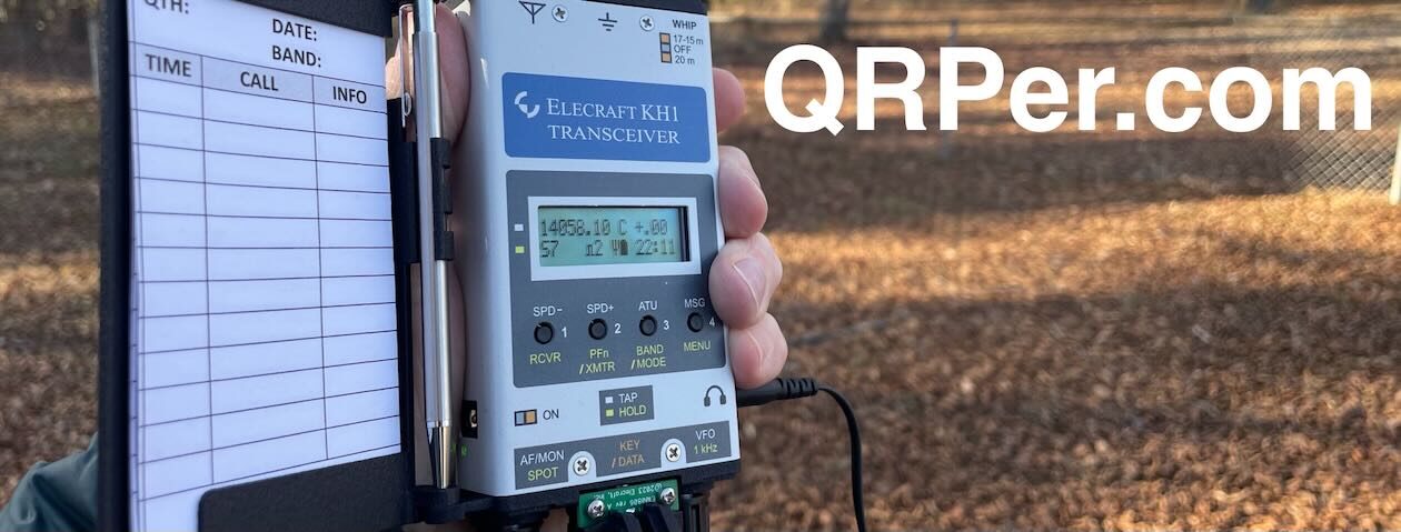
Friday, we set up a trap Inverted-V on a push-up pole, lashed to the campsite split rail fence. For the radio part, the goal was to put the new Elecraft KH1 through it’s paces. While most rave about this new hand-held CW rig, I still prefer my KX2. Anyway, Friday night with 3 watts on 40 CW with the KH1 and the inverted-V. As it was rainy, I ran the coax inside our Winnebago Solis and set up at the kitchen table (the Winnebago Solis is their smallest vehicle, really just an ergonomic camper van built on a Dodge RAM Promaster chassis).

With a 140 watt solar panel on top and two 100-ampHr batteries, you can boon dock off the grid for several days. Had a productive run of Qs sitting at the table, and with several other LICW members.

As the weather report for Sunday was bad, we decided to do a Summits-on-the-Air activation Saturday on near-by Mount Jefferson, a nearly 5000 ft peak named  for its original owners, Thomas Jefferson and his Father. This is a partial drive-up south of the town of West Jefferson (named for ?).

There are several trails on the top, including the Mountain Ridge Trail and the Lost Province Trail. The trails are incredibly well maintained, flat gravel trails, not like the rock scrabble of the AT, but a definite steep incline. Alanna did great climbing  the steep trail, only having to stop a few times to catch her breath.

About half way up, we were in thick clouds, with visibility only a few feet. It was ethereal. At the SOTA activation zone, there is a rock ledge where you can set up….but be careful, as you don’t want to tumble off the ledge, way down to the valley below. At first, Alanna operated in the clouds. She looked like a spirit SOTA babe emerging through the clouds.

Mt Jeff overlook in the clouds

A few hours later, a cold front came through and blew the clouds away. What a difference! We could see 70 or more miles, down the valley and into the nearby state of Tennessee.

Mt Jeff overlook in the clear

Unfortunately, there was a major solar flare, with an A Index of 12, so conditions were very rough. At first, I tried the KH1 as a hand-held with the attached 4 foot whip and one 13 ft counterpoise. To make conditions better, I set up the Elecraft AX1 miniature vertical on a tiny tripod and attached four 13 ft radials, in the trees and over the rock ledge. It was still an effort, but managed to get the required SOTA contacts. As Mt Jeff (W4C/EM-021) is both a SOTA peak and a NC Park natural area, it’s a two-fer. Unfortunately, my luck capped below the required number of POTA contacts. Thanks to all who tried to dig me out. The Reverse Beacon Network spotted  us around the country, but with very weak signals on 20 CW.

Mt. Jeff with KH1 & whip antenna
Mt. Jeff with KH1 & AX1 on mini-tripod

Sunday, the weather was hit and miss, so we decided just to drive the Blue Ridge Parkway (US-3378), stopping at breath taking overlooks and hiking some on the Mountains-to-the-Sea trail. The MST runs almost 1200 miles from the Great Smoky mountains in the western part of NC to Jockey’s Ridge State Park in the Outer Banks, where North Carolina meets  the Atlantic Ocean. We’ve section-hiked the MST, just as we’ve done on the Appalachian Trail.

Cooking  over an open campfire is the only way to get that great wood smoke flavor. Our hot dogs and hamburgers by campfire, with guacamole, were delicious.

K4AAC Alanna with guac & campfire

Looking forward to trying the KH1 in decent propagation conditions, as it may be the go-to for SOTA and overseas travel.

All-in-all, the clear clean mountain air and great mountain vistas were really therapeutic for our health, and the kind of medicine you can’t put in a bottle.

73 de K4RLC Bob

Fitting in some QRP SOTA & POTA on Mount Jefferson!

Looking back at last year (2021), if I had to pick out one of the easiest SOTA activations I made, Mount Jefferson would be near the top of the list. It’s a very accessible summit although not technically a “drive-up” summit because you will need to walk a short distance up a service road to the activation zone (AZ).

Mount Jefferson (W4C/EM-021) is located on and protected by the Mount Jefferson State Natural Area (K-3846), so when you activate Mount Jefferson for Summits On The Air, you can also claim the activation for Parks On The Air and World-Wide Flora and Fauna as long as you work at least 10 contacts.

What I love about POTA and SOTA “2-fer” sites like this is that you can set things up to be spotted in both systems (and often the WWFF system, too!) which increases your audience of hunters and chasers, thus increasing your odds of achieving a valid activation in all programs. It’s especially desirable if you’re a CW op and know you may potentially be in a spot with no mobile phone service for self-spotting; if, for some reason, RBN auto-spotting functionality is down with one program, the other serves as a backup.

Mount Jefferson is at least a two hour drive from my QTH, but it was easy pickings on April 29, 2022 because it happened to be within spitting distance of New River State Park where I was camping with my family.

Mount Jefferson (W4C/EM-021)

The drive to Mount Jefferson took all of 20 minutes which was a good thing because our family had other activities in store that day including some extended hikes!

Hazel (above) was so excited to to check out the sights and smells at this new-to-her park! Continue reading Fitting in some QRP SOTA & POTA on Mount Jefferson!

SOTA and POTA Field Report from Mount Jefferson State Natural Area

On Monday, March 22, 2021, I performed three QRP field activations in one day. I started off the day with a visit to Three Top Mountain Game Land, and then headed to Mount Jefferson State Natural Area for a POTA and SOTA activation before heading to New River State Park.

When plotting my multi-site activation day, I picked Mount Jefferson because it’s a SOTA entity (W4C/EM-021). I only realized later that it’s also a POTA entity (K-3846). I mistakenly assumed Mount Jefferson was a county park rather than an NC state park.  To do both a POTA and SOTA activation simultaneously is ideal!

Mount Jefferson (W4C/EM-021)

This was my first visit to Mount Jefferson and, frankly, I wasn’t sure what to expect in terms of hiking.

The park itself is amazing! North Carolina parks never let me down.

The entrance is near the base of the mountain and very close to the town of West Jefferson. The park road climbs up the side of Mount Jefferson –there are a number of spots to park, hike, and picnic.

I had not checked the trail map in advance, but I had read that the summit trail was accessible from the parking and picnic area at the end (top) of the park road.

I hopped out of my car, grabbed my SOTA pack, and very quickly found the trail head.

The trail is impeccably maintained and wide enough for vehicle use (no doubt these trails double as access for tower maintenance on the summit).

The hike to the summit from the parking are was incredibly short–about .3 miles. Normally, I’d want a much longer hike, but since I was trying to fit three site activations in a span of four hours, I didn’t complain.

On top of the summit, one is greeted by a typical cluster of transmission towers.

While I appreciate checking out antennas and towers, these are never a welcome site because they can generate serious QRM, making a SOTA activation difficult.

I also found a park weather station on the summit. Nice!

I searched around and found a spot to set up well within the activation zone but giving me a bit of distance from the towers.

Gear:

My Yaesu FT-817ND was desperate to get a little SOTA action, so I decided to pair it with the Chameleon CHA MPAS Lite using the Elecraft T1 ATU to find matches.

After putting the FT-817 on the air, I was very pleased to hear that the nearby transmission towers and power lines weren’t causing any noticeable interference.  This was a very good sign because, frankly, propagation was very unstable that day and I had real concerns about being able to work stations on 40 meters.

I hopped on the air and quickly realized I’d forgotten to hook my external battery up to the Yaesu FT-817ND. This meant I was running something closer to 2.5 watts as opposed to a full 5 watts. I decided to attempt the activation without the external battery and add it if needed.

I started operating on 20 meters and was very pleased to quickly rack up a number of contacts. I could tell that most of these contacts were via SOTA because I recognized the calls and primarily SOTA chasers.

Within 11 minutes, I worked 10 stations on 20 meters in CW. I was very pleased with how quickly those QSOs rolled in and how easily I logged the four needed for a valid SOTA and 10 needed for POTA activation–all on 20 meters.

Next, I moved to 40 meters where I worked two stations and 30 meters where I worked one. For sure, 20 meters was a much stronger band than 40 and 30 turned out to be.

After working 13 stations, I packed up.

Obviously, 2.5 watts was plenty for this activation!

I would have loved to stay longer, but frankly, I needed to stick to my schedule because I had one more park to fit in that day! (More on that in a future post and video!).

Here’s my QSOmap for the Mount Jefferson activation:

And here’s my full log:

Video

Even though I was a bit pressed for time, I still made one of my real-time, real-life videos of the entire activation. I hope you enjoy:

Next up will be an activation of New River State Park. I hope to post this early next week.

Thank you so much for reading this report!


Do you enjoy QRPer.com?

Please consider supporting us via Patreon or our Coffee Fund!

Your support makes articles like this one possible. Thank you!