
Many thanks to Lee (M0VKR) who shares the following field report and video:
SOTA CW Activation on High Willhayes Dartmoor
by Lee (M0VKR)
It was an overcast and breezy morning when wife Joanne and myself Lee, M0VKR set out on our latest SOTA (Summits on the Air) activation adventure. Our destination was High Willhays, the highest point in Devon UK – SOTA G/DC001, Dartmoor is well known for its rugged beauty and challenging terrain.
 We parked the car a short distance up the road from the army camp, slung our packs over our backs and set off. The gravel tracks leading to the summit stretched out before us and took a winding path through the moorland.
 A few sheep and cattle grazed in the rough grass as we made our way upwards on the gentle slope. It was a breezy morning and we had had rain a short while earlier. Despite the weather our spirits were high, and we were eager to reach the top and get on the air with the Elecraft KH1.
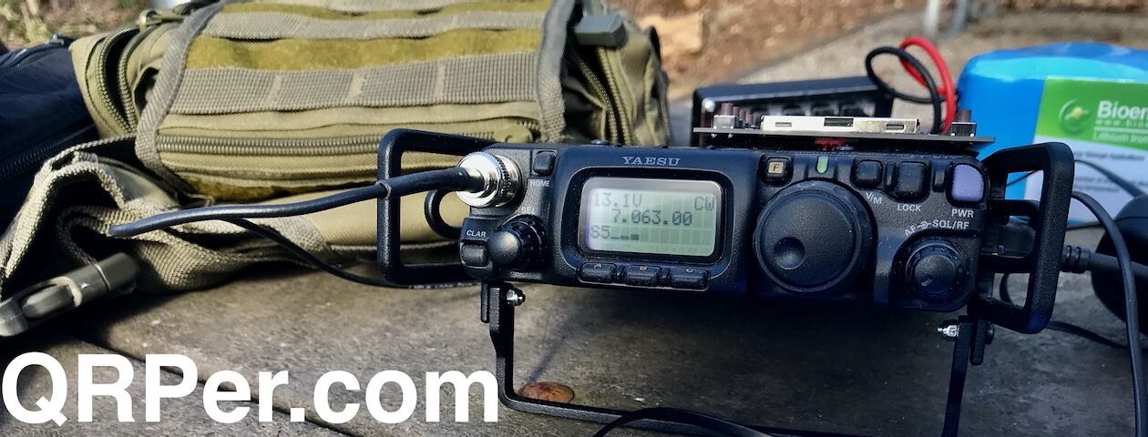
 In my pack was my now trusty Elecraft KH1 and an MPAS 2.0 vertical antenna, with the KX3 as backup, a reliable setup for such expeditions. I’m pretty sure I could halve the weight in my pack, but as it’s not a huge walk to the summit I don’t mind ferrying the extra gear to the top. The weather, though overcast, was adding a touch of drama to the landscape, and the breeze kept us cool as we trekked upward.
 Joanne, ever the supportive partner, helped carry some of the cooking equipment and victuals and she kept the mood light with her cheerful conversation.
 After a brisk hike, we reached the summit of High Willhays. The view, even under the Grey sky, was breathtaking. Rolling green hills and expansive moorland stretched out as far as the eye could see.

 I set about preparing the station, using the MPAS 2.0 vertical antenna, which is quick to deploy and ideal for the variable conditions we faced. Despite the less-than-ideal propagation conditions, I was determined to make the activation a success.
 Although the MPAS in vertical form isn’t very efficient on 40, I prefer to take advantage of the quick setup that it offers, one of these days I will look at adding a top section to make 40 more efficient, perhaps as a sloping inverted L or something similar, more reading of the manual required!
 With everything set up, I made the first call on the 40m band. My Friend Matt MW0KAX answered, he was essentially line of sight from Wales, so his signal was strong. That was the first and last contact on 40m. I changed to 20 meters, where the MPAS was more efficient for the little KH1 and it was able to breathe a bit easier. The tuner in the KH1 is nothing short of amazing, and quite happily tuned 40 meters in a few seconds.
The static crackled, and for a moment, there was silence. Then, a faint reply came through. The thrill of making that first contact was palpable. It still amazes me every time I make those first few contacts that QRP does work, even with a compromised antenna system. Despite the challenging conditions, My limited skill, Plenty of luck and the reliability of the equipment began to shine. All the equipment I was using was off the shelf, I hadn’t made a single thing myself, maybe one day.
One by one, contacts started to come in. Each short QSO contact was a small victory, a testament to perseverance and the joy of ham radio. It is necessary to persevere as a newer CW operator and use QRP power levels and poor propagation conditions. It’s non-negotiable after driving for 2 hours, and a 4km hike that we go home empty handed. I logged each contact meticulously, my excitement growing with every successful connection. Joanne watched on slightly bemused but very supportive of the hobby, sharing in the triumphs that each contact brings and providing much-needed encouragement.

By the end of the activation, We had made several QSOs. While the propagation conditions had been far from ideal, the activation was undeniably a success. We had achieved what we set out to do: connect with fellow hams across the airwaves from the summit of High Willhays for a SOTA activation.
As we packed up our gear, the breeze picked up, and the clouds began to clear slightly, offering a glimpse of blue sky. The trek back down was filled with reflections on the day’s achievements and plans for future activations. We both felt a deep sense of accomplishment. We had braved the elements, navigated the challenging RF conditions, and emerged victorious.
This activation, like many before it, was a reminder of the joys of ham radio, CW and QRP operation and the adventure it can bring. For me and my wife Joanne, High Willhays would always hold a special place in our memories, not just for its height, but for the heights that we reached together on the airwaves.
Activation Video:
Take care and Speak soon, 72,
Lee M0VKR


