Tag Archives: SOTA

Activating Anderson Mountain: My first drive-up one point summit

As AA6XA wrote on his blog:

To quote the W4C association manager Pat, KI4SVM, “Anderson is a drive-up with no other redeeming qualities.” This perfectly describes the mountain. It is easy to get to, at the top of Tower Road, right off of Route 16. The road to the top get a bit rough in places, but is passable in any car.

He had me at “no other redeeming qualities”–!

I must admit that all of the summits I’ve activated so far have been pretty amazing: offering up spectacular views, wildlife, and wonderful hiking opportunities. All of them were also on protected public lands like state/national/county parks.

Anderson Mountain (W4C/WP-012)

Earlier this year, I made a spreadsheet of summits I planned to activate. Anderson Mountain was one of them because of its convenient location in my travels to visit family each week. I had also been saving it for the day that I planned to activate a nearby park–Tuesday, July 6, 2021 was that day!

Earlier, I had an amazing activation at Mountain Island Educational State Forest using the Yaesu FT-817ND, T1, and my speaker wire antenna. I completed Mountain Island in enough time I could also pop by Anderson Mountain for a quick activation.  It was literally a six minute detour from my route, if that.

The mountain is directly off of US 16–the main highway between Newton/Conover and Charlotte.

You turn off of the highway onto a dead end road that leads to the summit. About halfway up, it turns into a single lane privately-maintained road that, as AA6XA noted above, is rough but passable in any car (well, save a Lamborghini but I’m guessing most SOTA ops don’t own one of those!).

The road to the summit is a straight–there’re no confusing forks in the road and it’s impossible to get lost.

Once on top, you’re greeted by a few clusters of communications towers. This is actually pretty common sight with smaller one point summits because they typically have superb line-of-sight to populated areas and are easily accessible by vehicle.

When you look around, you can understand why Pat would say it has no redeeming qualities: towers, rusty transmitter buildings, razor wire on chain link fences, and litter all over the place.

Not the sort of spot that would inspire Ansel Adams.

Judgement call

It’s worth noting here that, unlike POTA, you’re not allowed to operate from a vehicle during a SOTA activation–even at a “drive-up” summit. There’s no such thing as a mobile SOTA activation.

Indeed, you’re not supposed to operate in “the vicinity” of your vehicle either (although, there’s no distance noted and I’m guessing this is on purpose to allow leeway and the op to make a judgement call).

I set up in a little island of trees in the middle of a road loop on the summit. While I wouldn’t call it a hike, I did walk the entire summit after arriving to check for other operating spots, but decided to set up near where I parked the car. In fact, it’s really the only safe spot I noted in the activation zone to park since the road is single lane and you would otherwise block access to one of the transmitter sites. I thought about parking further down the road next to one of the transmitter fences, but I felt like that would have been on private property.

Side note: SOTA forbids operators from trespassing on private property without the owner’s permission. I checked the road very carefully for “no trespassing” signs, but the only ones I found were to keep people out of and away from the fenced-in transmitter sites.

I also thought about trying to operate in a spot on that little island where I couldn’t see my car as easily in the cluster of trees–to remove myself from the “vicinity” of the car–but that would have been awkward, too and only separated me an additional 10-15 meters or so. I chose the option where others could see me and I could see them if, for example, a Duke Energy service vehicle approached.

I was fully outside of my car, though, and not using it to support my antenna or any equipment–another important factor.

Sometimes as an operator you have to make a judgement call when you arrive at a site to stay within the rules and the spirit of the program. I’ve never had a SOTA or POTA activation where I felt I was splitting hairs until this one. I decided that this was the best scenario to activate Anderson Mountain in a way that wouldn’t inconvenience other property owners, nor cause suspicion that might lead to a future no trespassing sign on the road. It was the safest set up and I’m willing to bet most previous activators did exactly the same thing. I felt it was within the spirit of the program.

Now where was I–? Oh yes…
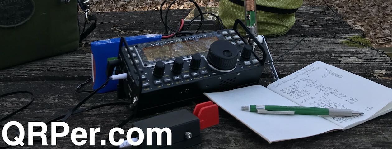
Gear:

On The Air

Since I used the speaker wire antenna at Mountain Island, I used it on Anderson Mountain as well. I deployed the entire station within 5 minutes max: herein lies the advantage of using an arborist throw line, a shack-in-a-box transceiver like the KX2, and a simple wire antenna.

I first hopped on 20 meters CW, spotted myself to the SOTA network (mobile phone reception was superb, by the way) and started calling CQ SOTA.

Within three minutes I logged K6YK, KT5X, W5GDW, and K0LAF which already validated this SOTA activation.

Wow–validating this activation was, as my daughters used to say, “easy peasy lemon squeezy.” 🙂

I added WB6POT and N0RZ for a total of six stations on 20 meters within five minutes.

I then moved to 40 meters SSB and worked K8RAT, W4NA, and WN4AT all within about three minutes.

Finally, I moved up to the 17 meter band and worked F4WBN (our well-known French SOTA chaser) and K2LT.

Packing up my gear was as quick as setting it up.

Video

I did make one of my real-time, real-life videos of the entire Anderson Mountain activation with no edits. If you need a cure for insomnia, I encourage you to watch or listen to it:

At least one redeeming quality…

I mention in the video that some readers and subscribers have confessed that they feel SOTA is less accessible to them than POTA or WWFF.  I would have to agree that summit activations are much less accessible than park activations.

For one thing, there are flat regions on our planet that lack prominences that qualify for the SOTA program. If you live in the middle of a prairie state, you may have to drive a great distance to reach the closest qualifying summit (although you might have a number of POTA and WWFF parks nearby).

In addition, summit activating generally involves hiking–which is actually the motivating factor for many of us (certainly for me as I love hiking).

Some would-be SOTA activators have mobility issues, however, and simply can’t hike great distances with gear on their backs.

This is where “drive-up” summits like Anderson Mountain come in: they’re much more accessible for those with health considerations.

If you live in an area with SOTA summits, but haven’t attempted an activation because you can’t do strenuous hikes, connect with local SOTA activators and ask for a list of “drive-up” summits. There are many of these around–some, like Anderson, are accessible because there are radio towers on top, other are accessible because they’re on a park with accessible vistas, or some are even in a mountaintop neighborhood.

Thank you

I’d like to thank all of you for reading this field report and I’d especially like to thank those of you who contribute to QRPer.com via Patreon and our Coffee Fund. While my content will always be free and QRPer is very much a labor of love, your support helps me purchase gear and supports my radio travels. With that said, if you’re saving up for your first radio or need to invest in your own kit, I’d rather you support yourself!

My goal with QRPer is to champion field radio operations and encourage others to discover the benefits of playing radio outdoors!

73,

Thomas (K4SWL)


Do you enjoy QRPer.com?

Please consider supporting us via Patreon or our Coffee Fund!

Your support makes articles like this one possible. Thank you!

An amazing SOTA activation on Mount Pisgah (W4C/CM-011)

Here in the Asheville, NC area, there’s one mountain that almost anyone can recognize by sight: Mount Pisgah.

Mount Pisgah is prominent because not only is it one of the taller summits bordering the Asheville basin, but it’s also home to the WLOS TV tower and and a cluster of public service and amateur radio repeaters.

I’ve been eager to activate Mount Pisgah for Summits On The Air (SOTA). Along with Bearwallow Mountain, and Mount Mitchell, it’s one of the most popular SOTA summits in the Asheville area.

One reason for its popularity is because it’s so accessible. Not only is there a dedicated, large parking area at the main trailhead off of the Blue Ridge Parkway, but it’s also an easy hike from the excellent Pisgah Inn, restaurant, and camp grounds.

Being so accessible from the BRP, the Mount Pisgah trail also receives a heavy amount of foot traffic. Being locals, our family tends to skip this trail when we’re venturing along the BRP because it can be so congested at times.

Mount Pisgah (W4C/CM-011)

On Tuesday, June 1, 2021, Hazel and I decided to hit Mount Pisgah fairly early and avoid the crowds.

We arrived at the trailhead around 8:15 AM and there were very few cars there–a good sign indeed!

Hazel was chomping at the bit to start our hike!

The trail is only about 1.5 miles with a 700 foot elevation gain, so not strenuous.

It was blissfully quiet and we only passed two other groups of hikers on the way up.

I’ll admit that I was keeping an eye out for black bears, though. We saw bears very close to the trailhead entrance on the BRP that morning. I may have mentioned before that black bears are not something to be feared here in western North Carolina; they typically avoid people and your chances of being fatally injured by a black bear are incredibly slim–right there with being struck by lightening.Still, the black bears that wonder near populated spots like Pisgah along the parkway are often fed by tourists and lose their fear of humans. Not only that, but they even expect people to be food dispensers. Not good. As we say around here, “a fed bear is a dead bear” because feeding bears leads to aggressive behavior and the poor creature’s eventual euthanization.

But I digress!

Hazel and I reached the summit and were happy to find that we were alone. Pisgah’s summit can get very crowded as there really isn’t a lot of space–only a large viewing platform next to the massive tower.

When we arrived on site, the summit was surrounded in clouds.

I briefly considered operating from the viewing platform, but knew I would have to cope with a lot of curious hikers while trying to operate CW. Since I’m not a good multitasker, I decided to do what many SOTA activators do: carefully pass under the tower and find an activation spot on the other side of the summit.

Hazel and I found a small overgrown trail used primarily by those working on the tower. I deployed my station in a small clearing.

Gear:

For this activation, I chose my Elecraft KX2 and paired it with the Chameleon CHA MPAS Lite which has quickly become one of my favorite SOTA antennas.

I deployed the CHA MPAS Lite perhaps 15 feet away from my operating spot, in the middle of a spur trail. I was able to extend the 17′ vertical without touching any branches. I rolled out about 20-25′ of counterpoise wire along the ground.

After setting up, it dawned on me that I’d forgotten my clipboard.  No worries, though! I simply flipped over my GoRuck GR1 pack and used the back as an operating surface.

On The Air

Not only was this a summit activation, but also a park activation–indeed, a two-fer park activation at that! The summit of Mount Pisgah is in both Pisgah National Forest (K-4510) and Pisgah State Game Land (K-6937).

If I’m being honest here–since I’m not a “numbers guy” and don’t follow my activation counts closely each year–it’s very tempting not to announce or count this activation in both the SOTA and POTA programs since K-4510 and K-6937 aren’t rare entities. The main reason for this is because, back home, I end up doing double entry with my logs: loading them via the SOTA online log submission tool, then entering them in N3FJP or TQSL for submission to the POTA and WWFF programs. It can be very time-consuming doing this.

I am working on a way to “massage” the ADIF file data so that I can submit it to both programs with less effort.

But, of course, I announced the activation on both SOTAwatch and the POTA site. At the end of the day, I’ve never *not* announced a dual SOTA and POTA activation because I can’t help but think it might offer up the sites to a new POTA hunter. It’s worth the extra log entry later.

Another plus with activating a site in two programs is that you’ll likely be spotted in both thus increasing your odds of logging the necessary contacts to validate your activations.

Turns out, snagging valid activations that Tuesday morning was incredibly easy. And fun!

Fabulous conditions!

I started on 20 meters CW and logged fifteen stations in eighteen minutes.  The band was energized because not only did I easily work stations from France, Slovenia, and Spain in Europe, but also stations all over North America from the west coast to as close as the Ohio valley and into Canada.

I wanted to play a little SSB, so I moved to the phone portion of 20 meters and spotted myself on the SOTA network. I worked five stations in eight minutes. Fun!

Next, I moved up to the 17 meter band and stayed in SSB mode. I worked five more stations in nine minutes. Had I only activated this site in SSB on 20 and 17 meters, I could have obtained both a valid SOTA and POTA activation in 17 minutes.

Even though I knew I needed to pack up soon, I decided to hit the CW portion of 17 meters before signing off.  I started calling CQ and was rewarded with sixteen additional stations in eighteen minutes.

Phenomenal!

All in all, I logged 41 stations.

Here’s the QSO Map of my my contacts–green polylines are CW contacts, red are SSB (click to enlarge):

A welcome interruption!

If you watch my activation video, you’ll note that as I moved to the 17 meter band and started calling CQ, another hiker popped in and introduced himself.

Turns out it was Steve (WD4CFN).

As Steve was setting up his own SOTA activation on Mount Pisgah next to the observation deck, his wife, Patty, heard my voice off in the distance giving a signal report.

Steve and I had a quick chat and coordinated frequencies so we wouldn’t be on the same band at the same time and interfere with each other.


After finishing my activation, I stopped by the observation deck and spent some time with Steve and Patty as Steve finished his SOTA activation and packed up his gear.

Steve was also using an Elecraft KX2 and strapped his telescoping fiber glass mast to the side of the observation deck to support a wire antenna. Very effective!

Hazel and I hiked back to the trailhead with Steve and Patty. It was so much fun talking ham radio, QRP and SOTA with kindred spirits. What an amazing couple!

Steve and Patty were actually on a multi-day camping trip in WNC and planned to hit two more summits by end of day. In fact, I got back to the QTH *just* in time to work Steve (ground wave!) at his second summit of the day. It was fun hunting someone I had just spent time with on a summit!

Steve and Patty: Again, it was a pleasure to meet you both!

Video

Here’s my real-time, real-life video of the entire Mount Pisgah SOTA activation:

A memorable activation indeed

Hazel and I both needed a little trail time that Tuesday morning. Hiking to the summit in the low clouds, taking in the views, enjoying a stellar activation and then meeting new friends? It doesn’t get any better than this.

I’ll say that I do love the Elecraft KX2 and CHA MPAS Lite combo. It makes for a compact and effective SOTA pairing that can be deployed so quickly.

A couple months ago, I ordered a SOTAbeams Tactical Mini fiberglass telescoping pole. I plan to pair it with my QRPguys tri-bander kit antenna.

If I’m being honest, though, I find that the CHA MPAS Lite is so quick to deploy–like 2-3 minutes tops–I’ve yet to take the Tactical Mini and Tri-Bander to a summit.  No worries, though, as I will eventually deploy this pair on a summit. Admittedly, I need to work on my mast guying skills in advance–let’s just say that I’m still in that awkward stage of struggling to manage each guy line as I try to keep the Tacmini vertical during deployment. I welcome any tips!


Do you enjoy QRPer?

Please consider supporting us via Patreon or our Coffee Fund!

Your support makes articles like this one possible. Thank you!

DAY4: A SOTA Adventure To Remember (Conclusion)

I hope the first two parts of my SOTA journey with Mark, NK8Q, has been interesting reading. It is really tough to put into words what the trip meant to me. Back in November I had my left knee replaced, and was preparing myself to possibly not be able to enjoy the luxury of being able to walk, run, hike and backpack. I never would have dreamed by the time this SOTA journey started that I already would have walked a half marathon on the new knee, nor be able to hike up summits. I have been truly blessed to be able to continue to do the things I enjoy. SOTA and POTA over the past year has renewed my interest in the hobby.

After we left Stony Man Mountain, we headed to the campground we were staying at along Skyline Drive. We lucked out earlier in the day by randomly arriving around 11:45 a.m. at the campground and even though the sign said it was full, the park ranger said to wait 15 minutes because there could be some checkouts right at the cutoff. We waited it out and at noon the ranger confirmed we had a campsite! Perfect…after 2 days of staying in motels, I finally got to camp in my new tent.

Once settled in, I thought it would be a good evening to set up my antenna and operate a little “late shift” on POTA – Shenandoah National Park (K-0064). I was just a bit too far off the A.T. to make it a “twofer”.  This yielded 16 QSOs and then called it  a night.

The next morning was also the last day of our SOTA trip. I woke up after a pretty restless night due to the fact my old body cannot tolerate being so low to the ground. I believe the last time I slept in an actual tent was in 1981 in boot camp at Parris Island. I am now a hammock camper and it sure feels much better on the back. So, back to the story. After breakfast we packed up and drove to the first of two SOTA summits before heading home.

The first was Pinnacle Overlook (W4V/SH-005). The climb took an unexpected wrong turn from the parking lot but quickly rectified. The hike to the summit was fairly steep, but there was beautiful flowers and rock formations and the summit was aptly named The Pinnacle. What a beautiful view of the Shenandoah National Forest.

We saw several thru hikers on our hike both up and back down the mountain after the activation. Several were interested in our ham radio operations. I found a perfect spot to operate from right along the Appalachian Trail and off to my left I could look over and see the view. I had 20 QSO’s and the bands were in decent shape.

It was time to head back down to the parking lot and continue our journey to the next stop, Hog Back Overlook (W4V/SH-007). There wasn’t much of a view once we climbed to the top of Hog Back, but met more through hikers, including one lady who was wearing a hat from Boston Marathon. Her trail name was GiGi, which is her Grandma name, which is also my wife’s Grandma name. She decided at age 65 she was going to hike the entire A.T. and had already run the Boston Marathon, so this was a bucket list item for her. I told her hiking the entire A.T. is my goal in 2026 when I’m retired and was nice to know there are hikers in our age group that are still able to accomplish these things. We gave her some trail magic, and Mark and I continued on our way to the top of the summit. There wasn’t much besides an old building which may have been a ham radio shack at one time, and some towers but not much of a view. We did a fairly quick activation and I had 12 QSO’s before packing it up. (I almost thought I heard the sound of banjos playing up there.)

We made a couple of other stops along the Skyline Drive, one was for the tunnel that was built along the route, and another stop to see the scenery from the outlook. It was time for me to start heading back to Lancaster County, which was about a 4 to 5 hour drive and Mark had two other summits he wanted to visit. What I did not expect to see at the one stop to look at the views was a lady who was sitting along the rock fence painting. I asked her if I could take a picture of her holding the picture she was painting and she gladly agreed. It took her about an hour to paint it and was finishing up when I arrived. After I left I regretted not thinking to ask her if I could have purchased the picture!

I arrived home around 5:30 pm on that Sunday evening and was completely exhausted. Mark sent me a text and told me at his next summit he was on the trail and saw GiGi again.

Thankfully, I had taken Monday off for a vacation day because I was exhausted from all the traveling Mark and I had done in 4 days. In addition to the driving, we did a lot of walking to the summits and operating. It was an experience neither of us will ever forget. We are already starting to plot our plans for next year for another adventure.

I’d like to thank Mark for putting this trip together and plotting out which Summits to do on each day and the best way to navigate to each destination. The hikers on the trail were all wonderful, and some of them asked questions about what we were doing, especially when we had our fishing poles at the summit with no trees. I used the HAMRS program for the 4 days, and other than some operator error, the program worked flawlessly. I especially would like to thank Thomas Witherspoon for allowing me to share my story on QRPer. Tom is an awesome ham and we share many of the same interests for POTA or SOTA, and we both enjoy antenna experimenting and our passion for QRP operating. Thank you again Thomas for the opportunity to share my experience, and I hope you enjoyed my SOTA experience.

73 Scott Lithgow
KN3A

SOTA: Activating Bearwallow Mountain with the KX2, MPAS Lite, and Hazel

The MPAS Lite vertical has an impressive view!

I’ve been receiving a lot of comments lately from readers and viewers asking to see more Hazel in my reports and videos.

Hazel, if you’re not familiar, is my brown, white, and freckled canine shadow.

Hazel requires absolutely no prep time to go on a hike and summit/park activation. She’ll go from a deep, dreamy sleep where she’s chasing squirrels and her paws are twitching, to wide awake, tail wagging and nose pointed at the door in 2 seconds flat.

All it takes is the sound of me putting on my hiking boots (which must be louder that I imagined).

On Monday (May, 24, 2021) the weather was beautiful and I decided to finally add Bearwallow Mountain to my list of SOTA activations. Hazel was ready for a short hike!

Bearwallow Mountain (W4C/CM-068)

Bearwallow is one of the most popular summits to activate in the Asheville/Hendersonville area of western North Carolina. Any semi-seasoned local SOTA activator probably has Bearwallow in the logs. Why?

The Bearwallow antenna farm is extensive!

For one thing, Bearwallow is a ham-friendly site. A number of local repeaters are on this mountain and some of our local clubs have access to the summit. Once–I can’t remember the year–I even spent time with a club (I believe it was the Roadshow ARC) on Bearwallow for the ARRL Field Day. It was a blast!

Bearwallow is also a very accessible summit.

The trailhead to the summit (Google Map) is tucked away in the Upper Hickory Nut Gorge area–and there’s ample paved parking unless you happen to pick a very busy day (basically, any weekend with good weather will be busy!). Hazel and I were hiking on a Monday morning, thus there was very little activity and loads of parking spaces.

Some years ago, Conserving Carolina acquired the summit and much of the land on Bearwallow Mountain. Their conservation easement protects this area from future development and opens it for the public to enjoy.

Conserving Carolina maintains the trail system to the summit and all of the hiker information and blazing.They do a brilliant job!

There are two options for hiking to the summit: a proper foot trail, or you can take the Fire Tower Road which is the best choice for hikers who need a more gentle incline and flat gravel hiking surface.

Click here for a map of the trails (PDF).

Hazel and I decided to go up the foot trail and descend via the Fire Tower Road to make a loop.

We spotted a number of plants in bloom on the way up.

The foot trail is an easy one to hike, too. It’s well-maintained, as I mentioned, and there are only a couple of steep-ish sections.

There are even opportunities to take in views on the trail.

When you reach the top of the trail, it opens onto a pasture.

And the views are panoramic!

There are cattle all over the summit, so give them wide berth.

Speaking of cattle, Hazel is quite fond of them…or at least what they leave behind.

She’s been known to roll in cow patties when she has the opportunity (or if I’m distracted with something else…like performing an activation!).

Hazel and I found a nice spot to set up the station well within the activation zone. On summits like Bearwallow where there are clusters of communications towers, I prefer not to set up next to them. This is where that 25 meter SOTA activation zone (AZ) comes in handy.

Gear:

I had actually planned to use my Elecraft KX3 on this activation, but after setting it up, I realized quickly that my power cord had developed a fault.

Fortunately, I packed a spare radio.

Knowing in advance that this would be a short hike–before leaving the QTH–I also packed the KX2 kit in my backpack as a backup. I don’t always have the luxury of packing a second radio, but wow! Am I glad I did that Monday!

Setting up the Chameleon CHA MPAS Lite vertical, of course, was super easy.

On the Air

I started the activation on 20 meters and spotted myself to the SOTA network via the SOTA Goat app. Of course, before leaving home, I had also set up an alert on SOTAwatch so that the spots page would auto-spot me via the Reverse Beacon Network (RBN) if I didn’t have mobile phone coverage.

In short? The contacts started rolling in. I was very surprised to have this sort of response on a Monday morning.

In 22 minutes, I worked a total of 19 stations including one summit to summit (S2S)–thanks for that, Eric (VA2EO)!

I was very pleased with the number of contacts logged in such short order because I only had a max of 25-30 minutes to be on the air before I needed to pack up and head back to the QTH.

Here’s the full log:

Activations like this one remind me of what one can do with QRP power and a modest antenna.

Sure, at one point–after I had worked at least my first four to achieve a valid QRP SOTA activation–I increased the power from 5 watts to a cloud-scorching 10 watts! 🙂

Here’s a QSO map of the contacts:

Video

Here’s my real-time, real-life (a.k.a. it’ll put you to sleep) video of the entire activation:

I must apologize for the audio in this one–it’s a little weak due to how the camera was set up.

Hazel at it again

So I brought along a retractable leash/lead for Hazel for this particular outing.

This leash allows her to roam more freely during our actual hike. On the summit, I locked the leash and attached it to my pack so it would keep her within 4 feet or so of where I was sitting which was cow patty-free.

At one point, near the end of the activation, when I was trying to manage a few calls, off-camera Hazel discovered that the leash unlocked, allowing her more flexibility to roam.

I looked up to discover that she found a semi-moist cow patty I somehow missed and was preparing to “enjoy” it. While sending CW and trying to keep from knocking down the camera, I used my left foot to put the brakes on her leash. She knew I was struggling, though, and tugged more.

I managed to stop her before even one paw plopped in the patty. Somehow. It was a very close call, though.

If you’ve watched my activation videos before, you’ve no doubt gathered that I’m not a multitasker. This little event really tested my ability to hold it all together on and off camera! 🙂

After packing up the station, Hazel and I took the Fire Tower Road back to the car. It was a very pleasant stroll and cow patty free.

Thank you for coming along with me on this SOTA activation and making it to the end of the report. You deserve an award! Please treat yourself to a local summit or park soon!

Thank you & 73,

Thomas (K4SWL)


Do you enjoy QRPer?

Please consider supporting us via Patreon or our Coffee Fund!

Your support makes articles like this one possible. Thank you!

Days 2 – 3: A SOTA Adventure To Remember (Part 2)

I would like to thank everyone for their positive and kind comments from my first part of the SOTA adventure with NK8Q. I have a slight correction to make, Cole Mountain was the first summit we did on Day 2. As you can see below in the pictures, there were no trees to hang our EFHW antennas, so we brought along our fishing poles. This generated a lot of interest from the A.T. thru hikers asking what we were doing. On particular hiker told us he’s seen others doing SOTA at summits throughout his journey from Georgia until that day. This was a fairly steep climb to get to, but the scenery was fantastic and well worth the walk. We offered trail magic to several of the hikers and we had very good conversation with them all.

Heading back down from the summit are a couple of other views we saw. There were some trees outside of the activation zone.

We packed up and started heading down the mountain to the parking lot around noon with the next destination Rocky Mountain (W4V/BR-001).

We drove almost 3 hours to get to this drive-up summit. The “S” turns and elevation changes were worth it though as there was so many spectacular views of the mountains. The last 4 or 5 miles was up a very steep gravel road that had me white knuckling until we got to the top. This was a site with several towers for different things and not a lot of view. I was able to get 10 QSO’s at the summit. I recall it was getting very warm that afternoon and I was not looking forward to the drive back down the mountain on the access road. I figured out how to do the manual shifting in my Tucson and Mark followed me down the hill. It was a non-issue and then we had a long drive to where we thought we would be able to camp on Skyline Drive.

I got my 4 SOTA QSO’s, time to relax.

When we finally got back onto paved roads and eventually into cell phone coverage briefly; we were hoping to find a place to get ice for the coolers and maybe a place to eat. Well, we found a gas station in the middle of nowhere with ice and a little store and they happened to be selling their own fried chicken and fries. When we got to the south end of Skyline Drive entrance, the sign showed all of the campgrounds were full. Since it was already getting dark, we made the decision to get on I-81 and head north and found a Super 8 Motel in Newmarket, VA for the night with the plan to get back to Skyline Drive at the Thornton Gap entrance. We got up early and looked for a gas station and a place to eat. Conveniently, Dunkin Donuts has a gas station as well (we didn’t realize that until after we got gas) but had a good breakfast sandwich each and I got a large coffee. I believe Mark is only the second person I’ve ever known who does not drink coffee. I believe my large cup was consumed before we got to Skyline Drive that morning, which I believe was about 18 miles.

First Summit of the day was Hazeltop Mountain (W4V/SH-004), which was south on Skyline Drive. The scenic outlooks were beautiful on the way to the summit.

Once we reached the summit, there was not much to see. I set up a few yards off the A.T. and made 15 contacts. The band conditions were pretty decent. This was my set up at this location.

Next stop – Hawksbill Mountain (W4V/SH-001).  It was just after 12 noon when we got to the parking area, and there was a good mile or so of steep uphill climbing. The reward at the top was worth the climb! I got another 20 QSO’s in the logbook at this summit.

This dial pointed to the many summits within view of Upper Hawksbill.

Final summit for the day was Stony Man Mountain (W4V/SH-002). This was another steep climb, but the reward was also a beautiful view.  I made 8 QSO’s and Mark and I shared the antenna and radio due to the limited space and all the people walking around at the summit.

I will continue with Part 3 of our journey to the Summits in Virginia in the next post. I hope I have half the writing skills that Tom Witherspoon has and that I was able to hold your interest in the SOTA journey that Mark and I did. I will wrap up the story with a Part 3. Thank you for taking the time to read this.

Scott Lithgow
KN3A

Scott Lithgow (KN3A) is a contributor on QRPer.com. Click here to check out his previous posts.

A memorable Bakers Mountain SOTA activation with the Elecraft KX2 & PackTenna 9:1

Besides Lane Pinnacle, there’s been one SOTA summit, in particular, I was eager to activate this year: Bakers Mountain (W4C/WP-007).

I practically grew up in the shadow of this little outlier mountain in Catawba County, North Carolina–my home was only a couple miles away as the crow flies and it has always been a bit of a landmark in my childhood stomping grounds.

Growing up, the land in/around Bakers Mountain was basically off-limits and privately owned. In the late 1980s, one of the land owners gave a large tract of land to the county to protect it from development (which started booming in the area around that time).

In June, 2002, while I was living in the UK, Catawba County open up the 189 acre park and its 6 miles of trails to the public.

I love Bakers Mountain park. Even though the mountain isn’t terribly tall (1780 feet/543 meters ASL) parts of the trail system are fairly strenuous. When I want to escape and clear my head, the Bakers Mountain trails are the perfect medicine.

Bakers Mountain: What’s in a name?

An interesting tidbit about Bakers Mountain that I learned from one of the park rangers: it was originally called “McBride Mountain in the late 1700s, but as more German settlers moved into the area, German family names became predominant.

The Baker family had large tracts of land in/around the mountain and, locally, people started referring to it as “Baker’s Mountain” sometime in the 1800s and the name stuck.

Officially, the name of the mountain is “Bakers Mountain” although, I suppose, it should have been called “Baker’s Mountain” or maybe “Bakers’ Mountain.” An apostrophe was never added, though.

It’s a source of confusion for those who make maps and refer to the mountain. In the SOTA database, it’s referred to as “Baker Mountain.” That is incorrect, of course, but the SOTA database is likely built upon one of the topographic map databases where it’s incorrectly labeled.

So there you go. Tuck away this bit of trivia and sound like a local next time you’re in Catawba County!

Now where was I? Oh yes…

So on Wednesday, May 19, 2021, I packed my Elecraft KX2 and PackTenna 9:1 UNUN antenna in the GoRuck GR1, and hit the Bakers Mountain trail system.

The weather was perfect, although the humidity was incredibly thick that day.

Mountain Laurels were in bloom and flanked portions of the trail.

I took the main red-blazed loop trail.

The trail is very well-marked and maintained with maps posted throughout.

At one point, you’ll happen upon the old home site.

The trail has a few steep sections, but overall is pretty moderate.

There’s no missing the summit trail.

Following the orange mountain top trail will take you to a gazebo and observation deck near the summit.

Keep in mind, though, that this is not the true summit of Bakers Mountain and isn’t close to the 25M SOTA activation zone. Still, the views are fantastic here, so take a breather and soak up the Catawba valley.

Click the pano image below to enlarge in a new window.

To find the trail to the real summit, you must follow the path crossing under the power lines near the observation area–you can’t miss it. While the public isn’t encouraged to take this path–and it is not a part of the Bakers Mountain trail network–a park ranger told me that the current owners don’t mind the odd SOTA activator following the trail to the summit.

The path–since it’s not a part of the public trail–is a bit overgrown. Follow this path until you intersect an overgrown narrow access road. At the intersection take a left and this will lead you to the true summit. The ring road around the summit is well within the AZ.

I found a little spot to set up among the trees on the summit. No views, but it was the perfect space to deploy the PackTenna 9:1 UNUN!

Gear:

On The Air

This being my first time activating Bakers Mountain, of course I made a real-time, real-life, no-edit video (see link below). Sorting out a way to set up the camera position took me longer than deploying the antenna and unpacking the radio! It can be a real challenge on a stony mountain summit.

The KX2 paired beautifully with the PackTenna 9:1 UNUN. I got a great match on 20 meters.

I started calling “CQ SOTA” and spotted myself on the SOTA network using the SOTA Goat app.

My first contact was SA4BLM in Sweden–I almost fell off of my rock!

Next, I worked KR7RK in Arizona, AE0XI in South Dakota, and HA9RE in Hungary! All in eight minutes.

Wow!

Next, I moved up to the 17 meter band where I logged AC1Z in New Hampshire, F4WBN in France, and KT5X in New Mexico.

Finally, I moved down to 40 meters where I worked K3TCU in Pennsylvania, K8RAT in Ohio, W4KRN in Virginia, and K4MF in Florida.

My total activation time was about 25 minutes.

QSO Map

Here’s the QSO Map plotting out my QRP contacts. I must say, that modest PackTenna did a lot with my 5 watts! That and some good Bakers Mountain mojo! 🙂

Video

Here’s my real-time, real-life, unedited video of the entire activation from start to finish:

Click here to view on YouTube.

That was fun!

When I hike at Bakers Mountain, I add spur trails and connectors to make it as long as can in the time frame I have. The trip back to the car was actually a longer hike than it was to the summit.

But I had a spring in my step.

I was absolutely chuffed that my first activation of this particular summit was so exciting and fun. It still blows my mind what can be accomplished with 5 watts and a modest wire. I can’t wait to go back again.


Do you enjoy QRPer?

Please consider supporting us via Patreon or our Coffee Fund!

Your support makes articles like this one possible. Thank you!

Day 1: A SOTA Adventure To Remember (Part 1)

First of all, thank you so much Thomas Witherspoon (K4SWL) for allowing me the space to tell my recent story from my trip to Virginia. I hope you find it interesting. I certainly do not have Tom’s writing skills so I’ll do my best.

A quick introduction. I was licensed in 1983, call KA3LUW, as a Novice mostly a CW operator. I upgraded in 1992 to Extra with the 20 WPM code. I was mostly interested in DX and around 1996 went through some life changes and became inactive for several years until about 2003 when my Dad (N3FWI – now SK) gave me his Kenwood TS 450 to sell. I put up a temporary antenna and discovered PSK31. That actually got me back into ham radio as Dad let me keep the radio. At that point I changed my Extra call from WY3X to KN3A. Over the years my interest is still chasing DX and contesting. In 2015, I was chasing the W1AW year long event for the ARRL Centennial so I could confirm as many states on as many bands and modes as possible. When 2016 started, my ham friend, Mark, K3MRK told me I should get involved with NPOTA (National Parks on the Air) which was also celebrating their 100th anniversary. I was just so burned out from ARRL the prior year that I did not get involved. My interest in the hobby also started to wane as well, as I got into fitness due to health issues.

Fast forward to 2020. Mark continued to praise the now POTA program and all the fun he was having with it. It seemed to be something I would also enjoy as I could walk, hike and exercise as well as discover portable operations. On March 14, 2020, Mark convinced me to do a POTA activation with him at the local Sam Lewis State Park (K-1418) near my QTH. It was very cold and windy but we had a successful activation and I was hooked. Since then I’ve done 75 activations from 9 unique parks in 3 states. To say I am hooked is an understatement!

I have another good friend Mark, NK8Q, who is an avid Summits on the Air activator and chaser (SOTA). Mark lives about 2.5 hours west of me, and last summer we met and activated two Summits together. The first was a drive up summit and the second one required a little bit of hiking to reach the summit. I like the idea of walking, hiking and backpacking so SOTA is also something I enjoyed doing last year.

Two years in a row K3MRK and I have tried to get to Dayton, only to have them cancel due to the pandemic. I had scheduled a week off of work and decided to keep the time off and contacted Mark – NK8Q about possibly doing a backpacking SOTA adventure.

We talked about different places we could go to activate, and ultimately we decided to do several 10 point summits along the Blue Ridge Parkway, Skyline Drive and along the Appalachian Trail. For me, this was going to be not only a SOTA activation, but in some instances the activation also counts for POTA.  We both left our homes early morning on May 20 and meet in Natural Bridge, VA and we would spend the next 4 days heading north, while activating different summits. We actually realized about 100 miles north of Natural Bridge that Mark and I were only about a mile apart heading south on I-81, so we took advantage of 146.52 simplex the rest of the way to our starting point and we used FM simplex driving from summit to summit.

We arrived at Natural Bridge just before 10:00 a.m. and Mark asked if I wanted to activate K-3972 (Natural Bridge National Park). Sure, why not, it would be fun to do a quick activation. We found a nice spot to set up the antenna and radio. My equipment for this journey was a Sotabeams Bandspringer Midi and my ICOM 705. I put 11 QSO’s into the log the short time we were there and was a nice warm-up for what was ahead.

After the quick POTA activation, we started heading to our first summit, which was Apple Orchard Mountain (W4V/RA-001). This was along the Blue Ridge Parkway and the views heading there were spectacular. Once at the summit we explored the area and then found our operating spots. I made 20 QSO’s and 3 S2S (summit to summit).

Second summit was Cole Mountain. The parking area was about 700 feet below the summit of 4,020 ft. Most of this climb was along a private road that goes up to several towers and they were cutting the grass. They waved as we walked up and were also very close to the Appalachian Trail (AT). Cole Mountain yielded 27 QSO’s in a very short period of time.

We hiked back to the parking lot and proceeded to our next summit of the day at Petites Gap Trailhead where we went to Highcock Knob (W4V/RA-014) where we hiked about 700 feet in just over a mile. This was a fairly rocky and difficult climb and being tired from other summits and the drive down first thing in the morning, it was nice to be the last summit of the day. The elevation at the peak is 3,073. Mark and I had some issues getting our antennas through the trees at this summit and wasted a lot of time. Once the issue was resolved, I made 8 QSO’s. Mark and I decided it was time to start heading back to the parking area and call it a day. Since we were on the Appalachian Trail, we met many thru hikers heading from Georgia to their final destinations in May. Every one of them were really nice and eager to find out what we were doing at the summits and we made sure we had “trail magic” as they call it on the A.T. We carried extra water and snacks, and they were always much appreciated by the hikers. Just before we got back to the car, we met up with a hiker from Minnesota who was hanging his bear bag in a tree and he was preparing to camp for the night. When Mark and I got back to the car I thought, here I am with a cooler full of ice cold beer, I bet this man would appreciate a beer or two. I went back and he couldn’t get to the car fast enough! If you are ever hiking on the A.T. make sure you bring some trail magic as well. In the picture below, Mark was using my rig and we were right at the summit.

We left and went looking for a place to camp for the night. There were no campsites available so we stayed in a very old motel that I was afraid was going to be full of bed bugs or something. We survived and day 2 of the SOTA adventure was ready to begin.

(Part 2 is next)

Scott Lithgow (KN3A) is a contributor on QRPer.com. Click here to check out his previous posts.

Activating The Pinnacle: Amazing SOTA & POTA fun with the Elecraft KX2 and Chameleon MPAS Lite

Last Tuesday (April 20, 2021), I decided to make a detour to a park I had never visited before: Crowders Mountain State Park (K-2726).

It’s actually quite odd that I’ve never activated this park during the weekly trip to do a little caregiving for my folks: Crowder’s Mountain State Park is a reasonable detour especially compared to some of the more remote parks I’ve visited recently.

What’s really impressive about Crowders Mountain is that although it’s not as large as a national park and it’s very close to the city of Gastonia, it has no less than two unique summits that qualify for Summits On The Air: The Pinnacle and Crowders Mountain.

Both summits are accessible from the main park visitors’ center via a well-maintained trail network.

The propagation forecast looked pretty grim and after my last activation, I thought I might increase my chances of success by hiking to both summits in one visit. This made sense because I would only need 4 contacts per summit to have a valid SOTA activation and I could combine the contacts from each summit to hit 10 total contacts to activate the state park.

I decided to call the park and ask how long it would take to hike to both summits: the ranger told me “about 5 hours, or less if you’re fast.” That meant that once I added in my setup/pack up times and on-the-air time, I would be staring at a minimum of 7-8 total hours.

I (wisely) decided to pass on that opportunity. I simply didn’t have enough time in my schedule for that many hours at the park. That, and I didn’t want to feel rushed–I wanted to enjoy my outdoor time.

I decided instead to activate one summit and simply plan on spending more time on the air then plan to come back to the park for the second summit on a different day.

Before going to bed Monday night, I checked out the trail map and decided to activate The Pinnacle.

Crowders Mountain State Park (K-2726)

I arrived at Crowders Mountain State Park around 11:00 AM local–the weather was nearly ideal.

I had pre-packed all of the radio gear and supplies in my GoRuck GR1 rucksack, so once I arrived, I grabbed the pack, put on my hiking boots, a hat, and hit the trail.

I’ve read that Crowders Mountain State Park can get very busy and it’s no surprise as the park is within easy reach of Shelby, Gastonia, and the Charlotte Metro area. Fortunately, I was visiting on a Tuesday morning, and while I saw at least 30+ cars parked in the main parking lot, I passed other hikers only a few times on the Pinnacle trail. It’s a sizable park and can easily swallow 30 groups of day hikers!

I followed the orange-blazed trail to the summit of The Pinnacle.

The hike was very enjoyable and, frankly, not what I would consider strenuous, but it had enough elevation change to feel like a proper hike. I allowed an hour to reach the summit, but it only took about 40 minutes or less.

Near the summit, there’s a fork in the trail: if you take a right, it leads to the summit, if you take a left, it’ll lead you on a much longer Ridgeline Trail that will eventually take you into Kings Mountain State/National Park–you’d better believe I’ll try that one day in the future! It would be fun to activate two parks and a summit all on foot.

I took a right at the fork and the .2 mile long trail zig-zagged up the side of The Pinnacle.

I was a little surprised to be greeted by the sign above.  It’s true that the summit area is quite rocky and you have to watch your step, but this warning is a bit extreme in my opinion (especially since the SOTA activation I did with my daughter recently was orders of magnitude more dodgy!).

If you are activating The Pinnacle and don’t want to climb up the rocky path, no worries. I’m certain the area where the sign is located is well within the SOTA summit activation zone.

The Pinnacle (W4C/WP-010)

Although The Pinnacle is only a “one point” summit, when you reach the top you’re greeted by some impressive views.

The Pinnacle and Crowders Mountain are both outlying mountains so are the tallest points in the area offering beautiful, long-range vistas.

There were perhaps a half dozen hikers hanging out on the summit. I found a quite spot to set up on the side of the summit only a few meters from the top.

Gear:

On The Air

During the hike, my buddy Mike (K8RAT) sent a text noting that propagation on 40 meters was non existent. He suggested I play on 20 meters and above, possibly including 30 meters.

Later on, I found out that Mike was 100% correct. Several POTA activators that day mentioned on the POTA Facebook group that 40 meters was completely wiped-out.

I installed the Chameleon MPAS Lite vertical antenna next to me. I’ll admit that I was a little worried it might be too rocky to plunge the MPAS Lite’s stainless spike in the ground, but it turned out not to be the case.

The CHA MPAS Lite has really proven itself as an invaluable SOTA antenna. While the stainless spike adds weight to my pack, it’s less fussy than dealing with guy lines and telescoping fiberglass poles and much quicker to set up.  You do need enough ground to plunge that spike into, but if there are trees and bushes on the summit, it’s probably doable!

I started recording a video (see below) of the activation, spotted myself to the SOTA network (even though it would have likely auto-spotted me via the Reverse Beacon Network)  and hopped on 20 meters.

Solar Flare!

I had no idea at the time, but we were experiencing a solar flare which explained why 40 meters was completely wiped out.

The effect on 20 meters was simply epic.

I called CQ and was instantly rewarded with a long, continuous string of stations. Within 26 minutes, I had already worked 23 stations with 5 watts and the MPAS Lite vertical. A stark contrast to my previous POTA activation.

The view from my shack

And here’s the thing: the flare opened up 20 meters to local/regional stations as well. I worked stations as close as South Carolina, Georgia, and Tennessee–this is simply unheard of normally. Of course, stations on the west coast were also booming in.

I was a little surprised I didn’t log any European stations on 20 meters, but I suspect they were having a difficult time competing with the strong signals from North America during the flare.

I short: the band opening was amazing fun and even renewed my faith in our local star just a wee bit. (Ha ha!)

After playing on 20 meters, I decided to try 17 meters.

Wow! Without a doubt, I worked more stations on 17 meters in short order than I’ve ever worked during a field activation. In 10 minutes, I worked 12 stations. As with 20 meters, the flare opened up stations that would normally be in my 17 meter skip zone.

Here I was worried about logging the ten stations needed to validate my park activation!  After logging 35 total contacts, I decided to pack up.

Here’s a QSO Map of the activation (click to enlarge):

Video

Here’s one of my unedited real-time, real-life videos of the entire activation:

(Click here to view on YouTube)

Although the weather app on my phone wasn’t showing any afternoon thunderstorms nearby, there were some patchy dark clouds forming on the other side of the summit and the winds were shifting, so I decided to call it a day and enjoy the hike back down the mountain.

Fortunately, the clouds never amounted to anything but I don’t take my chances with spring weather–it’s fickle, especially along the North Carolina/South Carolina line. That, and frankly, I needed to stick to my travel schedule.

I took my time on the way back down and simply soaked up the outdoors.

I love doing field activations of all types, but I’ll admit that I’m becoming addicted to Summits On The Air because of the hiking opportunities it presents.

There are few things in the world I enjoy more than hiking.

When I’m on a trail, all of my concerns seem to dissolve.

Perspective

On the return hike, I passed by a group of three hikers. All of them were staring at their phones while hiking and one tripped on a tree root in the path. They caught themselves before hitting the ground.

I’ll admit I was thinking at the time that mother nature was saying, “Hey! Wake up, disconnect and enjoy the beauty around you! You need some perspective!” 🙂

I’m already looking forward to visiting Crowders Mountain State Park again.  I believe I’ll return within a month and hike to Crowders Mountain, activating both the summit and park.

Sometime, I’d like to hit the trails as soon as the park opens and, perhaps, activate both Crowders Mountain and Kings Mountain parks on foot. That would likely take an entire day when I include the time on the air, but it would also be a lot of fun.

I was telling my wife yesterday that I actually enjoy writing up the odd field report on QRPer. It hit me that there are a couple of reasons why…

For one, a number of readers have reached out and thanked me because they enjoy living vicariously through my field reports and videos.  I get it. My family and I enjoy watching YouTube videos of travelers around the world. We avoid the personality-driven channels and focus more on those that are less “produced.” It gives us an opportunity to travel to, say, Spain, France, Finland, or Turkey when we can’t presently do so. It pleases me to no end thinking that my reports and videos could, even in some very small way, offer a little vicarious travel to others.

Secondly, writing up these reports gives me an opportunity to re-experience some of my field time and sort through photos I might have taken along the way. Although it takes a few hours to write a report, I truly appreciate the experience.

Thank you, dear reader, for spending time with me during this outing!


Do you enjoy QRPer.com?

Please consider supporting us via Patreon or our Coffee Fund!

Your support makes articles like this one possible. Thank you!

Rendezvous Mountain Field Report: Activating three individual sites on one summit!

Last Wednesday (April 7, 2021), I managed to block out most of the day to play a little radio in the field. When I have opportunities like this, I usually take one of two approaches: either make a multi-park and/or summit run, or go further afield and activate a site or two on my bucket list.

I chose the latter.

Two of the very few sites from my 2020 Park Bucket List that I hadn’t managed to activate were Rendezvous Mountain Educational State Forest and Rendevous Mountain State Game Land. When I created my bucket list, both of these parks were very rare: one was an all-time new one, the other had only been activated once. In 2021, they were still rare but both had activations logged.

When two park entities are this close together, I will do my at-home research in advance and search for a spot where the boundaries of the two parks might overlap opening an opportunity for a one activation two-fer.  Although there are exceptions (like Elk Knob)  when a park and a game land share a common name, there’s a decent chance their boundaries overlap, possibly even in an accessible area.

Fortunately, I discovered last spring that Rendezvous Mountain did indeed have an accessible spot where both the game land and state educational forest meet. I pinpointed it on Google Maps and embedded the URL in my park bucket list spreadsheet:

I can’t overstate how important one of these lists is to an activator who loves exploring different  sites. When the weather outside is horrible and activating isn’t a good option, spend your time indoors doing research for a day when you can hit the field!

Tuesday evening, I decided to finally hit this Rendezvous Mountain two-fer. Since the weather was forecast to be beautiful, I also wanted to fit in a proper hike, so I started searching for a nearby summit as well.

Click to enlarge

Turns out, there was a SOTA summit called “2543” (named after its height above sea level in feet) that was accessible from a Rendezvous Mountain Educational State Forest parking area. An easy four mile round-trip hike. Score!

Next, I found the 2543 summit on a topo map and compared it with the location I’d already plotted for my two-fer. Turns out, they were very close to each other–likely within 100 meters. I was able to confirm with confidence that the summit and game land could be activated at the same time. The state forest map was a little too vague to confirm its exact boundary.

I originally found this site using the NCWRC maps and topo/trail maps.

Here’s the interesting part: the game land parking area I planned to use was within 50-100 meters of the SOTA summit. If I wanted to, I could easily turn this summit into a drive-up activation. But again, I wanted to hike, so I plotted a trip to the parking area of Rendezvous Mountain Educational State Forest.

My plan was to hike to the summit, activate it and the game land as at the same time, then hike back to the Rendezvous Mountain Educational Forest’s parking area, grab a picnic table and activate the state forest separately.

I arrived on site around 11:30 and spent a few minutes confirming that I was hitting the correct trail (as there are multiple trails in this forest).

The trail head is at the last parking area, simply keep following the paved road which quickly turns into a gravel/logging road.

Turns out, it couldn’t be easier to find the summit trail (should you decide to make this same activation): simply drive to the last parking area in Rendezvous Mountain Educational State Forest, and continue walking up the road past the metal gate. This road will take you past the visitor’s center, turn into a gravel road, then pass the fire tower road on your right.

Simply continue following the main road for two miles. There are a few branches on this road and I did take one thinking I was sticking to the main road, but quickly discovered it was a dead end and had to back-track. In general, follow the most traveled road and you’ll be fine.

The summit is fairly nondescript since it’s lower in altitude and covered in trees. Look for a short spur road, two miles in, near the game land gate (where you could park if you wanted to do a drive-up activation).

As I hiked to the site, I realized that the logging/access road is actually the boundary between the game land and the state forest. A promising sign!

When I arrived at the short spur road that ended on the summit of 2543, I was very pleased to discover that the game land/forest boundary followed the spur road and was all well within the SOTA activation zone! Brilliant!

Rendezvous Mountain State Game Land (K-6941), Educational State Forest (K-4859), and
SOTA Summit 2543 (W4C/EM-082)

The game land, state forest, and summit all met on an old road bed that was flanked by tall trees.

This meant that I could activate all three sites in one go and–since there’d be no need to activate the state forest separately–still have enough time to perhaps activate Kerr Scott Game Land later in the afternoon on my way home.

You can see the state forest sign on the left, the game land sign on the right–both within the SOTA activation zone.

Point of clarification about park boundaries and “two-fers”

POTA is fairly clear about where park boundaries are in terms of counting a park in an activation, “The activator and all the equipment you use must be within the perimeters of the park, and on public property. […] If the park is part of a trail system or river, you need to be within 100 feet of the trail or river.”

In order to claim a two-fer, there needs to be park overlap. Technically,  you can’t straddle a map line between two (non-river/trail) park sites and activate them as a two-fer because you and your equipment can’t be in both places at the same time if there’s no property overlap. In POTA, there is no buffer area around a park unless it’s a trail or river.

SOTA is specific and gives you a 25 vertical meter activation zone which forms a contour line around the true summit (not a secondary, nearly as high area). Little room for interpretation here.

For Rendezvous Mountain, I decided it was a POTA two-fer because I activated on a road that is also a marked and blazed trail used for recreation/access for both the game land and forest–and both of these areas are a part of the over-arching Rendezvous Mountain State Forest.

Had this been a boundary defined by an imaginary (surveyed) line without a common trail or road, there would have been no point of overlap, thus no two-fer.

This was actually the first time I had been in this particular situation. All of the other multiples I’d activated in the past had vast areas of geographic overlap.

Again, no one but the POTA activator actually knows the truth, and it would be incredibly rare that anyone would ever question you after your logs have been submitted. There is no POTA Police and it’s not even a contest–it’s a group activity. It’s all about following the rules to the best of your ability, exercising due diligence,  and being honest with yourself.

Now where was I?

Gear:

At the site, I used my new compact arborist throw line bag.

It worked even better than I had expected.

I was concerned that the line wouldn’t deploy as smoothly as the line does from my larger arborist storage cube, but it deployed perfectly!

On the air

I deployed my Vibroplex EFT-MTR end-fed antenna across the road bed and connected it to my Elecraft KX2 with attached KXPD2 paddles.

This made for a very compact and simple setup: in situations like this, I love the compact size of the KX2 since it can easily fit on my clipboard where I also log on paper.

I also brought along my Google Pixel 3 and made a video of the entire activation (see below).

Propagation was very unstable, but I hoped that this site would be rare enough to attract SOTA, POTA, and WWFF chasers thus helping me log my needed 4 for SOTA and 10 for POTA/WWFF.

I first hopped on 20 meters CW where I quickly worked seven stations in eight minutes–from Utah and Arizona, to France, Spain and Germany. An excellent start!

I then hopped on 30 meters (using the KX2’s ATU instead of removing the SMA cap on the EFT-MTR), and worked one station in Missouri.

Next, on 40 meters CW, I logged another six stations in six minutes.

I then connected the microphone and worked a Summit-To-Summit contact on 20 meters SSB. I was very pleased to put K4AAE/P in the logs because I had difficultly working other stations on 20M SSB.

Finally, I moved to 40 meters SSB and worked a total of four stations in five minutes.

All-in-all, a total of 19 contacts logged in a total of 45 minutes on the air.  Not bad for QRP on a poor propagation day!

QSO Map

Video

I made one of my real-time, real life videos of the entire activation. Check it out below or via my YouTube channel:

Photos

As I hiked back to the car, I took my time and enjoyed the weather, the hike, and the solitude. Here are a  few extra photos from the camera roll:

Thank you for reading this field report!

If you ever pass by North Wilkesboro, North Carolina, I highly recommend this site. It’s very rare that you find a site that is a SOTA, POTA, and WWFF entity and that can be activated by a pleasant 4 mile RT hike, or as a drive-up.

I’ll plan to hit Rendezvous Mountain again next year!


Do you enjoy QRPer.com?

Please consider supporting us via Patreon or our Coffee Fund!

SOTA and POTA Field Report from Mount Jefferson State Natural Area

On Monday, March 22, 2021, I performed three QRP field activations in one day. I started off the day with a visit to Three Top Mountain Game Land, and then headed to Mount Jefferson State Natural Area for a POTA and SOTA activation before heading to New River State Park.

When plotting my multi-site activation day, I picked Mount Jefferson because it’s a SOTA entity (W4C/EM-021). I only realized later that it’s also a POTA entity (K-3846). I mistakenly assumed Mount Jefferson was a county park rather than an NC state park.  To do both a POTA and SOTA activation simultaneously is ideal!

Mount Jefferson (W4C/EM-021)

This was my first visit to Mount Jefferson and, frankly, I wasn’t sure what to expect in terms of hiking.

The park itself is amazing! North Carolina parks never let me down.

The entrance is near the base of the mountain and very close to the town of West Jefferson. The park road climbs up the side of Mount Jefferson –there are a number of spots to park, hike, and picnic.

I had not checked the trail map in advance, but I had read that the summit trail was accessible from the parking and picnic area at the end (top) of the park road.

I hopped out of my car, grabbed my SOTA pack, and very quickly found the trail head.

The trail is impeccably maintained and wide enough for vehicle use (no doubt these trails double as access for tower maintenance on the summit).

The hike to the summit from the parking are was incredibly short–about .3 miles. Normally, I’d want a much longer hike, but since I was trying to fit three site activations in a span of four hours, I didn’t complain.

On top of the summit, one is greeted by a typical cluster of transmission towers.

While I appreciate checking out antennas and towers, these are never a welcome site because they can generate serious QRM, making a SOTA activation difficult.

I also found a park weather station on the summit. Nice!

I searched around and found a spot to set up well within the activation zone but giving me a bit of distance from the towers.

Gear:

My Yaesu FT-817ND was desperate to get a little SOTA action, so I decided to pair it with the Chameleon CHA MPAS Lite using the Elecraft T1 ATU to find matches.

After putting the FT-817 on the air, I was very pleased to hear that the nearby transmission towers and power lines weren’t causing any noticeable interference.  This was a very good sign because, frankly, propagation was very unstable that day and I had real concerns about being able to work stations on 40 meters.

I hopped on the air and quickly realized I’d forgotten to hook my external battery up to the Yaesu FT-817ND. This meant I was running something closer to 2.5 watts as opposed to a full 5 watts. I decided to attempt the activation without the external battery and add it if needed.

I started operating on 20 meters and was very pleased to quickly rack up a number of contacts. I could tell that most of these contacts were via SOTA because I recognized the calls and primarily SOTA chasers.

Within 11 minutes, I worked 10 stations on 20 meters in CW. I was very pleased with how quickly those QSOs rolled in and how easily I logged the four needed for a valid SOTA and 10 needed for POTA activation–all on 20 meters.

Next, I moved to 40 meters where I worked two stations and 30 meters where I worked one. For sure, 20 meters was a much stronger band than 40 and 30 turned out to be.

After working 13 stations, I packed up.

Obviously, 2.5 watts was plenty for this activation!

I would have loved to stay longer, but frankly, I needed to stick to my schedule because I had one more park to fit in that day! (More on that in a future post and video!).

Here’s my QSOmap for the Mount Jefferson activation:

And here’s my full log:

Video

Even though I was a bit pressed for time, I still made one of my real-time, real-life videos of the entire activation. I hope you enjoy:

Next up will be an activation of New River State Park. I hope to post this early next week.

Thank you so much for reading this report!


Do you enjoy QRPer.com?

Please consider supporting us via Patreon or our Coffee Fund!

Your support makes articles like this one possible. Thank you!