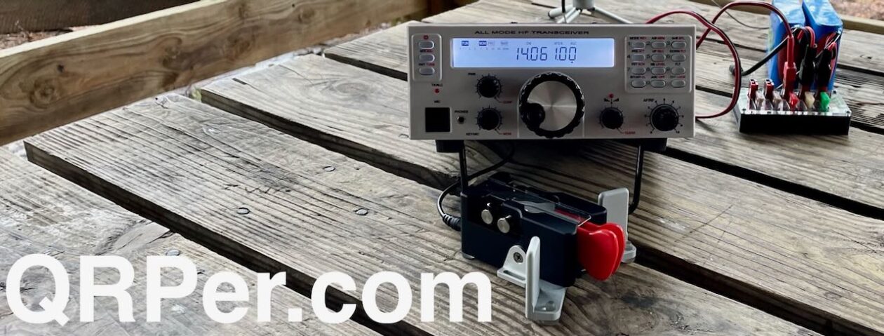
Jonathan KM4CFT reached out to me recently to inquire if I was interested in trying his CFT1 QRP transceiver. The inquiry both surprised and delighted me as I’ve never had such an opportunity.
I nearly said no because I am no antenna expert and, as this rig has no internal antenna tuner, I’d need to learn more about antennas, SWR, and resonance.
My limited antenna experience dates back to when I first entered the hobby. I had ZERO antennas and no idea where to start. An acquaintance suggested I make a home-brew linked dipole and gave me a few pointers in doing so. I vividly remember limping through learning how to trim an antenna. That project taught me that I want as low a SWR as possible and to cut the antenna for the portion of the band on which I want to operate.
homebrew linked dipole
Those of you who read my articles here on QRPer know that I use an Elecraft KX2 for my field operations. I’m very happy with this radio and love that it has an internal antenna tuner. But the CTF1 does not. Here is where my hesitation and trepidation at trying this unit entered the picture. I figured the antennas I use on a regular basis might not play nice with the CFT1 and hence my reluctance to say “yes” to this opportunity.
“Craig”, my KX2
But this is ham radio, right? In ham radio, we relish challenges because they are opportunities to learn. This was my opportunity to learn not only about antennas in general but also to be more thoughtful as to how I deploy them in the field. This was an opportunity for growth.
I dug out the RigExpert Stick antenna analyzer I purchased nearly three years ago and tested each of the antennas I currently have, just for jollies. I understand that many factors impact SWR – height of the antenna, coax length, proximity of other objects, etc. For the purpose of this exercise, I just wanted a ball park idea as to what antennas I could or could not use with this rig without a tuner.
I found both the home-brew linked dipole and the Chelegance MC-750 would work fine. Out were the EFRW and AX1. As I’d been hankering for an EFHW in my kit, I purchased the Sparkplug EFHW and trimmed it. These kinds of projects intimidate me because I do not have much experience with them; however, one cannot learn what one does not attempt.
I used the CFT1 on three activations: April 25th at the Savannah National Wildlife Refuge (NWR) (US-0522) with the Chelegance MC-750, April 30th at the refuge again but this time with the Sparkplug EFHW, and Thursday, May 1st at George L. Smith State Park (US-2179) with the Chelegance again.
It was a warm day at the refuge on April 25th. I selected an open area in which I had set up in the past. There were wild blackberries growing directly under the oaks in the shade. The view was lovely and, when not engaged with the activation, the red-wing blackbirds, coots, and other birds kept me entertained. Unfortunately for me, the sun moved out behind the oak trees not long after I arrived and I soon called QRT to avoid being baked.
the field in which I set upwild blackberriescooter out sunning itselfwater lillies in the impoundmentswhat is not to love about that view!?
I was pleased with the QSO map for this activation – 27 contacts on 40, 20, and 17 meters over the course of an hour and a half.
QSO Map for Savannah NWR 4-25-2025 Source: qsomap.com
My second experience with the CFT1 was on April 30th, again at the Savannah NWR, however, this time using the Sparkplug EFHW. I found a different spot, one I passed up before but was usable today as it was freshly mowed. There were wonderful, tall oak trees at this location which afforded shade and high, unencumbered branches for installing an antenna aloft. Continue reading The POTA Babe Tries the CFT1→
Glenn W4YES and I headed to Camden, SC the first week of April for some much needed rest and relaxation. Usually when I travel, I schedule a POTA activation or two. However, this trip I decided to try something new – getting on the air QRP at our Airbnb.
Camden is the oldest inland community in South Carolina. According to the town’s website, the earliest permanent settlers arrived in 1750. They experienced a crushing defeat during the Revolutionary War when the Patriots were defeated in the Battle of Camden. After the Civil War, the town “evolved into a tourist mecca for Northeners and Midwesterners seeking a warmer winter climate.” Those tourists brought money and an equine culture developed around racing and polo.
Our first day in Camden, we visited the Revolutionary War Museum. Though small in size, the museum’s exhibits are of excellent quality. They do a great job explaining who lived in the area, the quandary they faced as to whether to be a Loyalist or Patriot (it wasn’t as easy a choice as it might appear), and battles fought there.
Our second day, we explored the National Steeplechase Museum. This museum explores the history of steeplechasing and the personalities involved – owners, trainers, jockeys as well as those who care for the horses. The museum pays homage to Marion duPont Scott who developed the Springdale Race Course where the museum is located. This race course hosts two prominent annual competitions – the Carolina Cup and the Colonial Cup.
National Steeplechase Museum
an old scale used to weigh jockeystrophy room
We also spent some time driving through and walking in the historic neighborhoods of the city. The weather was gorgeous! Everywhere we looked, there were flowers – azaleas, wisteria, viburnum, and dogwoods (including the pink variety we do not see in Savannah).
a dogwood in full splendorazaleas at the corner of a homeviburnumpink dogwood
After exploring the area, it was time to explore the airwaves QRP at our Airbnb. To do this, I brought Craig, my KX2, and a home-brew linked dipole antenna. This is an antenna I built three years ago, when I first got into ham radio. At that time, I had no home station but wanted to get on the air portable for POTA. Despite knowing almost nothing about antennas, I built a usable dipole that became my main POTA antenna for quite a while.
the homebrew linked dipole (photo from GA State Parks on the Air event)
Why did I bring this antenna to Camden? I have the opportunity this month to try the CFT1, a QRP transceiver, by Jonathan KM4CFT. Because the rig does not have an internal antenna tuner, I am reacquainting myself with the subject of resonance and why it matters in antennas.
I set up a home-brew linked dipole Wednesday evening under some trees in a space between the Airbnb and a small lake on the property. The antenna was roughly 20 feet in the air.
the lake from the Airbnb2nd location for antenna by lake
My RigExpert Stick analyzer gave me 2.1 at 7.040 –
Thinking I could do better, I moved the antenna (a real pain to do with a dipole) to a different tree with a limb 30 feet high. (Frankly, Glenn and I were amazed I could snag that limb.) This setup generated better a SWR reading – 1.61 at 7.040 MHz.
Now the true test – how well would I be heard?
the bench at which I operated Wednesday eveningRBN picking me up Wednesday evening
CW nets are a great place to get on-the-air experience with morse code. It was my code buddy Caryn KD2GUT who first introduced me to the OMIK net. I found those who participate in this CW net to be welcoming and accepting of CW operators of all levels of proficiency. Over the past several years, the ops in this net have watched my skills grow and become friends.
Dennis NT4U and Steve W0SJS split net control station (NCS) duties. This evening, it was Dennis’ turn as NCS. As he is located in northern Georgia, I figured he would hear my QRP signal. He did and checked me into the net with a RST of 589. The icing on the cake was that I heard a station he was unable to hear – Charles AI4OT in Virginia – due to the S9 noise at Dennis’ location this evening. I notified Dennis of Charles’ check in so he was added to the check-in list for that evening. Way to go homebrew linked dipole and Craig!
The next day, Glenn did some exploring and found a better location on the property – a hill behind the Airbnb and some sheds. Several large oaks in this relatively open area offered prime limbs to snag with an arbor line. I installed the antenna on a limb roughly 25 feet up in the air.
open area at back of Airbnb propertylooking up into canopy at limb I used Thursday evening
Before attempting to check into another net, I spotted myself on QSO Finder, a new website and spotting tool by Mike N4FFF and Becky N4BKY of Ham Radio Duo. I had three exchanges, one each with Joel KE8WIC, Tom NG4S, and James KJ3D.
Spotting myself on CW QSO Finder
On Thursday evenings I check into the Sideswiper Net, a wonderful group of guys who meet on 40 or 30 meters (depending on propagation). Most of those who check in use a sideswiper (also known as a cootie) key but, like the OMIK CW net, they are welcoming of anyone who wants to participate no matter the level of proficiency or key. I’ve asked lots of questions of the members and appreciate their patience schooling me about CW nets.
The NCS this evening was Darrell AA7FV who is located in Arizona. The noise on 40 meters was rough but Darrel did copy me with a RST of 349. Two other stations – Bill WA4FAT in Alabama and Steve W1SFR – also copied me at 559 on this band.
When the net moved to 30 meters, my signal was worse. However, I expected that, as by this time it was dark and I didn’t want to mess with lowering the antenna to disconnect the link between the 40 and 30 meter wires. Darrel in Arizona could barely hear me (he gave me a RST of 129) but Bill could still copy me and acted as relay between our signals. I was thrilled that I had now checked into both nets QRP this week!
the RBN picked me up again
Even better, after the Sideswiper net, my code buddy Caryn KD2GUT and I were able to have our weekly code buddy QSO. We managed a 20 minute QSO on 40 meters before being swallowed up by noise and QRN on her end. Caryn is located on Long Island, NY. The previous night in the OMIK net, my signal was a 229 at her QTH. But tonight, we were both 599 and rocking it on the airwaves.
operating in the dark
During the Sideswiper net and my code buddy QSO, I sat head copying in the dark under the moon and thought, “It doesn’t get any better than this, right?”
Before we left the Airbnb Friday morning, Glenn spied several pitchforks sitting by the sheds. We picked one up and decided to have some fun, with our version of the famous piece “American Gothic” by Grant Wood. I had a difficult time keeping a straight face (watch the video linked down below) but eventually we got the shot.
“American Gothic” by Grant Wood source: Wikipediaus goofing off creating a version of the piece before checking out
QRP has its limits; however, I was sufficiently impressed by my experience on this trip that I will travel with a rig from now on. I’d like a better antenna and have ordered an EFHW as that is probably my best bet for a resonant antenna. This hobby NEVER becomes boring because there is always something to learn.
I look forward to trying the CFT1 and my new EFHW antenna when it arrives. How will that turn out? Stay tuned…
Equipment Used
[Note: All Amazon, CW Morse, ABR, Chelegance, eBay, and Radioddity links are affiliate links that support QRPer.com at no cost to you.]
I love living in the state of Georgia. The state contains diverse natural spaces – mountains and valleys in the north, rolling hills and forests in the middle, and a plain extending to the coast with wetlands, marshes, and forests.
source: Georgia DNRsource: GA DNR
The Georgia State Parks on the Air event celebrates and draws attention to state parks scattered throughout these spaces. For this year’s event (April 5th and 6th), I signed up to activate George L. Smith State Park (US-2179), a park located a little over an hour from my home. I’ve activated this park several times in the past – for POTA as well as the K2D special event.
To do something different and to qualify for the hike-in bonus (100 points) for the event, I planned to hike the Deer Run Trail. This trail runs past the historic mill on site and through a wooded area on the southeast corner of the park. To qualify for the bonus, I had to hike at least 1 mile from my vehicle so I walked a section of the outer loop trail.
water released under the mill on the lakeiris blooming
The hike was pleasant. Daisy and I walked through a forested area bordered by cypress bottomlands and farmland. Several benches along the path offered hikers a quiet place to relax. I was surprised by how many people we encountered.
the path leading from the mill – somewhere I’ve wanted to explorethe trail is well markeda spot to relax on the trail
We finally reached the junction of the loop and .7 mile trail, the latter having a power line running along it. Here was another bench set admist a mixture of pines and hardwoods. A tall pine directly across from the bench had a branch about 30 feet high, just perfect for the dipole antenna I brought, that is if I could reach it.
the junction of the .7 mile trail and 3 mile loop trailpine tree I spied for my dipole antenna
I removed my throw bag, arbor line, and throw weight, and tossed the line to see how close I could come to that branch. My line and weight ran over a broken branch forming a notch about 10 feet lower. I tugged to remove them and stared in amazement when the line abruptly broke free and fell at my feet…WITHOUT the weight attached. Oh crap! I was so gung-ho to nail that branch that I forgot to securely tie the weight to the line. (doh!)
my throw weight lodged in the notch
I stared in amazement, my mind slowly processing my situation. I did not bring an additional weight because I stopped carrying it since I never needed it (until now that is) and wanted to travel light for today’s hike. Shoot! Now what?
I spent the next 15 minutes trying to find a branch long enough to reach that spot as well as throw sticks at the weight. Nothing came close to dislodging it.
Well, I could just throw in the towel. But POTA Babes don’t give up that easily. I had an obligation to the event as I signed up to activate this park and hunters would be looking for me.
The only items in my pack I could attach to the arbor line and throw were an insect repellant bottle and my Nalgene water bottle. The insect repellant bottle I rejected because of its spray trigger which could definitely get stuck on a branch. But the Nalgene bottle might work. Daisy and I drank some water to lighten it. I tied the arbor line to the lid, found a branch about 15 feet up in the air, and tossed the bottle. Would this even work?
Nalgene bottle
It did! I know you antenna purists out there are shuddering. However, I figured a lower antenna was better than no antenna at this point. I brought two antennas with me for this activation: the Tufteln EFRW and a home-brew linked dipole I built roughly three years ago. A dipole is an amazing antenna, even if homebrewed. I figured my signal needed all the help it could get with the lower height and power lines nearby so I chose to use the dipole.
homebrew linked dipole antenna (40-30-20 meters)
Daisy and I settled across the trail in the understory to shade ourselves from the sun. One leg of the dipole ran across the hiking trail. To give the antenna as much help as I could, I secured both ends of the dipole roughly 6 feet up in foliage. Where it crossed the trail, it was high enough anyone would pass easily underneath it.
I took a breath, pressed the ATU button to activate the internal antenna tuner, cleared a frequency, and began calling CQ. I had no idea what to expect. Continue reading The POTA Babe Loses Weight→
Spring has arrived in Savannah bringing great POTA weather. There are still parks within a two-hour drive of my home QTH that I have yet to activate. To check one more off the list, Daisy and I headed to Di-Lane Wildlife Management Area (WMA) this past Wednesday, March 26th.
Di-Lane WMA (US-3744) is located just south of Waynesboro, Georgia. You may recall this town because I mentioned it in a previous article. It is known as the Bird Dog Capital of the World. Why? The town hosts the Georgia Field Trials – a competition that evaluates a bird dog’s ability to find and point flocks of quail. Waynesboro is well suited to the sport given the layout of land and large numbers of quail in the area.
Waynesboro water tower source: thetruecitizen.com
By now you are probably wondering what the heck bird dogs have to do with POTA. The land Di-Lane WMA occupies was formerly owned by Henry Berol, heir to the Eagle Pencil Company in New York. (A side note: he named the plantation for his two daughters Diane and Elaine.) Mr. Berol was an avid bird dog supporter and developed the plantation to host the trials. After Mr. Berol’s death, the land was eventually purchased by the Army Corps of Engineers as wetland mitigation for Lake Richard B. Russell. It is currently managed by the Georgia Department of Natural Resources with a focus on bobwhite quail.
There are several entrances to the Di-Lane WMA. The one I chose off Herndon Road is flanked by a brick wall and iron bird dogs atop the two pillars which pay homage to the plantation’s past. Just inside the gate is a large barn and check station for hunters.
entrance to Di-Lane WMAbarn by check station inside entranceWMA map Source: GA DNR
I drove past this area and found a quiet spot at the edge of Dove Field 1. Despite sunny skies, the temperature was quite comfortable in the mid-seventies.
driving in the WMAour road along dove field #1
Everywhere I looked, spring was evident. Flowers were prevalent – bluish and yellow wildflowers, white flowers on wild blackberry vines, and big clusters of flowers on a large bush. Not to be outdone, the sides of the roads were edged with lush, bright-green grass.
There were several trees beside this road of a sufficient height for the end-fed random wire I prefer to use. What I didn’t realize is that instead of a POTA activation, I was actually here to practice throwing my arbor line as it took me ten or so tries to snag a branch at the height I preferred.
tree for EFRW antennafeed-end of the EFRW antenna
I posted on the CW channel of the Discord POTA server the day prior that I would activate this park. I received a request from Cainan N9FZ that I use a frequency to assist regional hams working to hunt all the Georgia parks. Hence it wasn’t a surprise that Cainan was the first to work me when I called CQ on 40 meters. He was followed by five ops before I moved to 20 meters. Continue reading More Dogs for the POTA Babe→
January and February have been such busy months that not much POTA has happened for this POTA Babe since my trip to southwest Georgia. Wednesday, February 26th was too gorgeous a day to sit inside. I set aside my projects and Daisy and I headed to a new park – Mead Farm Wildlife Management Area (WMA).
source: Google Maps
Mead Farm WMA (US-9776) is a two-hour drive from Savannah, GA, my home QTH. I visited this area last year when I activated Yuchi WMA (US-3778) in January 2024. Within sight of Yuchi WMA is Plant Vogtle, a nuclear power plant on the Savannah River managed by Georgia Power, a subsidiary of Southern Company. I spied the four cooling towers (all complete and now active) in the distance during the drive.
cooling towers at Plant Vogtledaffodils on the side of the roadquaint post office in Girard, Georgia on the drive
Mead Farm is one of the smaller WMAs. It consists of 200 acres, almost equally split between uplands and wetlands. Unlike other Georgia WMAs I’ve visited, the roads back into the park were blocked so I opted to set up in the parking area. Thankfully, the road near the entrance to the park was not busy so vehicular noise didn’t present an impediment to my activation.
entrance from the roadparking area with information kiosksignage at the far side of the parking area
The weather in southern Georgia has been uncharacteristically warm – high temperatures in the upper 70s. With clear skies overhead, I parked on the eastern side of the parking area taking advantage of shade provided by pine trees. Those pines would also allow me to orient the Tufteln EFRW antenna toward the northwest.
source: GA Dept. of Natural Resourcesscenery outside the fenced-in parking areaarbor line and antenna in pine tree
POTA, at this point, has become comfortable. (Notice I didn’t say easy because you never know what unexpected event will happen during POTA as noted in my past QRPer.com articles.) In an effort to shake things up, I decided to use all three keys currently in my POTA kit: the VK3IL-design paddle gifted to me by Brian K3ES, the BaMaTech III paddle, and the CW Morse Pocket Single Paddle/Cootie key.
VK3IL-design paddle, BaMaTech III key, CW Morse Pocket Single Paddle/Cootie key
Note: This is the fourth article for my trip to southwest Georgia at the beginning of January 2025. If you didn’t read the previous article, it is available here: Doerun Pitcher Plant Bog WMA
January 5th, Daisy and I hit the road again for one more POTA activation toward my goal of activating 30 new parks in 2025. The trip to southwest Georgia, though cut short, was productive in that I had three successful activations, I worked through the obstacles I encountered, and I got the break from my obligations and responsibilities I needed.
There are still quite a few parks on the eastern side of Georgia I have yet to activate. As I had no time constraints today, I picked a park close to the Georgia – Florida border: Ceylon Wildlife Management Area (US-9772), an hour and a half drive from my home.
What I didn’t realize until I began researching and writing this article is just how significant this park is. It is the newest wildlife management area (WMA) in the state of Georgia and 24,000 acres in size. It not only has environmental significance but is also important for national security reasons. The Naval Submarine Base Kings Bay is the home port of the U.S. Atlantic Fleet’s ballistic missile submarines and adjacent to this property. Keeping this land out of the hands of resort, residential, and commercial interests protected the fleets access to the Atlantic via the Satilla River.
Image from Submarine Group Ten source: New Georgia Encyclopedia
The property is named after Ceylon Mill Village, a town established on the site 1874 for the purpose of processing timber. The town “was named for the Southeastern Asia country (current-day Sri Lanka, then British Ceylon) where tea was grown and shipped to the world.”
The town is long since gone and today it is wildlife that occupies the land, including the gopher tortoise, Georgia’s state reptile. This WMA has one of the highest densities of gopher tortoises, somewhere between 3,000 and 4,000, in all of Georgia. I came across one of their burrows while looking at the pre-bellum and antebellum graveyard on the property.
gopher tortoise burrow at the base of a gravestoneantebellum gravepostbellum grave
The park is a short drive from Interstate 95 though the signage and entrance is not as readily visible as many WMAs. After passing the information kiosk, I began looking for a site not so heavily wooded. There was evidence of controlled burns and management for the cultivation of longleaf pines on the land. Longleaf pines are an important species in the southeast, one that is in decline due to centuries of logging.(I wrote about the importance of this habitat in my article on my activation at Oliver Bridge WMA.)
entrance area with information kioskcontrolled burn areayoung longleaf pine taking advantage of the open canopythe open road begging to be explored!
I found a cleared area and pulled off the side of the road next to a downed tree. The tree would serve as my seating area and Daisy could lay down in the shade it provided. Though the temperatures were still chilly, the cloudless and sunny skies over head would certainly overheat anyone laying around in a fur coat.
my parking spotnapping in the shade from the fallen tree
I had the EFRW installed in short order, oriented it to the northwest, settled on the trunk, and got down to business.
getting “comfy” on my woody QTH
I stuck with 20 meters for most of the activation. That band gave me 37 QSOs in an hour. After some hunting, I worked 11 contacts on 15 meters and three contacts on 40 meters before calling QRT. (Look at the contact waaaayyy out west in California.)
Even though I had good cell service and internet access at this site, I was not successful in hunting many activators due to the band conditions. I had three park-to-park (P2P) QSOs – Rod K4DSX, Jeffrey WJ3FF, and Marshall K1SN but ended up with credit for 10 P2P QSOs. Rod was a three-fer, Jeffrey was a two-fer, and Marshall was a five-fer! (Is there such a word?)
Ceylon Wildlife Management Area POTA QSO Map 1-5-2025
This is a park to which I plan to return. Ceylon WMA is easy to access; there is more territory in it begging to be explored; and I have cell service to spot myself and hunt other activators. With this successful activation, I now have four activations toward my goal of 30 for 2025 and 26 yet to go. Where will my next POTA adventure take place? Stay tuned…
Equipment Used
[Note: All Amazon, CW Morse, ABR, Chelegance, eBay, and Radioddity links are affiliate links that support QRPer.com at no cost to you.]
Note: This is the third article for my trip to southwest Georgia at the beginning of January 2025. If you didn’t read the previous article, it is available here: Chickasawhatchee WMA (US-3739)
In POTA and camping, one may plan and prepare; but no matter how much of that one does, there are invariably challenges that arise pushing you out of your comfort zone. Challenges put one into what I call “ham radio mode”. You know what ham radio mode is, right? You evaluate a situation, assess your available resources to address the problem, and implement a solution with those resources. The trip to southwest Georgia presented several unexpected challenges.
The first unexpected challenge was that of my keys. I brought two paddles – the VK3IL design paddle and the mini palm paddle. Upon plugging it in, the VK3IL would only send dahs. So I defaulted to my backup, the mini palm. However, something was wrong with the connector on the back as randomly, the dit paddle would stop working. Ugh! After my first activation, I used my CW Morse straight key which I brought along because of Straight Key Night on January 1st. I hadn’t used a straight key for POTA in ages and, though a little challenging at first, it was a good change of pace.
CW Morse straight key
The second unexpected event was the soles of my old riding boots peeling back from the boots themselves. This happened as I was packing up my equipment at Chickasawhatchee. Thankfully, I found a Family Dollar store on the way back to Kolomoki Mounds State Park, purchased some JB Weld glue, and repaired them Thursday evening while sitting by the campfire.
boot sole coming off
The third unexpected event (don’t such things often come in threes?) were the cold temperatures at night. I did check the weather forecast before departing Savannah. However, it’s been nearly thirty years since I’ve camped in 30 degree weather and the weeks leading up to the trip had been unseasonably warm – highs in the 70s and lows in the mid 50s. So while I knew intellectually that it would be cold, I wasn’t thinking from an experiential perspective.
The first night I couldn’t get comfortably warm despite having a Northface sleeping bag (rated for 25/40 degrees) and a SeatoSummit Thermolite Reactor Extreme liner. I also threw on top of Daisy and I (she had a sleeping pad and bag of her own), a survival blanket I keep in the car for emergencies.
Late into the first night, I remembered a moving quilt/blanket also in Kai’s trunk for emergencies. I was too cold to retrieve it from the car that night. But for the second night, I laid it on the floor of the tent under Daisy and then wrapped it over both of us. Though the situation that night was better than the first, I was still not comfortably warm. (This is why winter is my least favorite season – I spend all winter trying to keep my hands and feet warm.)
frost on the hood of my car
While I disliked throwing in the towel, I also didn’t want to suffer through two more nights of frigid weather. I tried to remember that the goal has to serve me and not the other way around.
a stinkbug at the campsite – look at the pattern and coloration on it!
After tearing down camp and packing the car, Daisy and I headed northeast back home with a planned stop at Doerun Pitcher Plant Bog Wildlife Management Area (US-7882). It is a relatively small WMA – only 600 acres. The land was purchased in 1994 from a family estate and named for the pitcher plants found on site.
source: Google Maps
Pitcher plants are carnivorous plants. According to Wikipedia, they have a “deep cavity filled with digestive liquid” in which insects are trapped and drown. There are over 100 species of carnivorous plants worldwide and three New World (North and South America) genus including sarracenia which are found at this WMA. The three species one can view at this park are the yellow pitcher plant (sarracenia flava), hooded pitcher plant (sarracenia minor), and the parrot pitcher plant (sarracenia psittacina).
yellow pitcher plantshooded pitcher plants – Photo by David McAdoo, Source: https://plants.ces.ncsu.edu/plants/sarracenia-minor/
I was able to view all three species though they were not in their prime due to the cold temperatures.
This WMA is easily spotted from the road. It is a short drive into the property where one encounters a kiosk and trail to the pitcher plant bog. As there was no one present and no power lines in the parking lot, I decided to set up here for my activation.
entrance to the park
On the edge of the parking lot was a pine tree with branches low enough to reach with my arbor line. There were plenty of parking spaces to the left of my car so there was no issue running my antenna northwest across the lot. That enabled Daisy and I to sit in the sun (again, it was chilly in the shade here) and see anyone approaching in case I did need to move my antenna. I installed the Tufteln EFRW easily and readied myself to get on the air.
our QTH – Daisy is snoozing in the sun!
Unfortunately, I did not have sufficient cell service to access the POTA site at this park. I texted Glenn and he spotted me on 14.058. As I had a four-hour drive ahead of me, this was a park at which I would not linger so sticking to one band would have to suffice.
Twenty meters did not disappoint. In fifty minutes, I had 23 contacts, many of whom I knew – Steve N2YLO, Todd W2TEF, Ed KN9V, Brian K3ES, Eric WZ5MM, Rick K8BMA, and Bob AC9MG. Though the POTA exchange may be short and not challenging, I always enjoy seeing ops I know on the air during an activation. It puts a smile on my face. (I just wish I could knew and remember everyone’s name. I sent the wrong name to Carlos AE2W – sorry about that!)
QSO Map for Doerun Pitcher Plant Bog WMA 1-3-2025
With this park successfully activated, it was time to head home to Savannah. The other parks I had hoped to activate during this trip – Kolomoki Mounds State Park, Eufaula National Wildlife Refuge, Lake Walter F. George WMA, Silver Lake State Fishing Lake, and/or Lake Seminole WMA – would have to wait for another trip.
But that isn’t the end. Just like Ginsu knives, there is more! As I had set aside Sunday for this trip, I resolved to find a park near Savannah to activate that day. What park would I pick? Stay tuned…
Equipment Used
[Note: All Amazon, CW Morse, ABR, Chelegance, eBay, and Radioddity links are affiliate links that support QRPer.com at no cost to you.]
Note: This is the second article for my trip to southwest Georgia at the beginning of January 2025. If you didn’t read the first article, it is available here: Elmodel Wildlife Management Area.
Thursday, January 2nd, Daisy and I headed to Chickasawhatchee Wildlife Management Area (WMA). The park is a short 45-minute drive from Kolomoki Mounds State Park. We drove through more small towns, past peanut warehouses, chicken houses, and cotton fields. Though chilly, it was a gorgeous day with cloudless, sunny skies promising warmer temperatures as the day progressed.
source: Google Mapspoultry house on the drive to and from the parkcotton in the field
The state of Georgia has 14 river basins and 52 watersheds. The Chickasawhatchee Swamp occupies 30,000 acres along the Flint River Basin and 20,000 of those acres are protected inside the Chickasawhatchee WMA (US-3739). According to the Georgia Department of Natural Resources, the swamp is among the largest freshwater swamps in the southeastern United States. It is unique in that “the collection of spring and surface water tributaries unite in bottomlands where the limestone bedrock is thin and soft, giving it a relatively direct connection to the local aquifer.”
source: New Georgia Encyclopedia
The park is well marked and the signage easily viewed from the road. I entered from the northwest corner off Georgia Route 62. In front of me was a packed, red-clay road just begging to be driven. I knew I had an activation scheduled but the desire to explore relegated that activation to the back burner. I drove for nearly an hour in the WMA exploring the park as my own private safari. I was in heaven!
kiosk after entering the parkthe road into the parkI think this is a tilled dove field for hunting.bottomlands in the park – a nice, little freshwater swamp
Around 1 PM, we reached an intersection of two roads in an open area. It was time to stop exploring and take care of business – my POTA activation. At the intersection was a large oak into which an EFRW could be installed and plenty of sun so Daisy and I could sit outside and stay warm. (Though the temperature had warmed considerably from earlier in the day, I still felt chilly in the shade.)
Daisy is ready to POTA!arbor line in tree getting ready to hoist EFRWfeed-end of the antenna connected to my Tom Bihn bag in which I keep my coax and throw kit
Up went the Tufteln EFRW and soon I was on the air. Given the time of day, I opted to begin with 20 meters. Jeff W4JSH was the first to answer my CQ. Over the next half an hour, the calls rolled in. I then jumped to 15 meters for two calls and then 17 meters for six calls. As I had access to the POTA page at this WMA, I tried hunting other activators but was successful with only one – Harry K9DXA at US-1001.
my setup – note the straight key which will be discussed in the next article
Before finishing out the day, I texted Glenn W4YES and he remoted into our ham shack. We worked one another on 40 meters (I gave him a 599 but on his end, I was only a 339). I then worked two more callers on 40 meters including John K4ZI. I was his first POTA contact ever. How awesome is that!
By this point in the day, the sun was lower in the sky, taking the warmer temperatures with it. I packed up my equipment and headed back to Kolomoki Mounds State Park.
This evening I attempted something I’ve never done when camping – build a campfire. Usually it is too wam for a fire when I camp. However, the temperatures would be in the lower 30s tonight again and I hankered to sit by a fire. I know how to build a fire as my ex-husband had a wood stove and I built many a fire in it. It wasn’t long before I had a blazing fire going. I felt like the character played by Tom Hanks in Castaway: “Me….Build….Fire!”
Daisy lounged in her sleeping bag nearby while I sat next to the fire, poking it periodically. Ahhhh. A lovely end to a lovely day. Where to next? Stay tuned…
Equipment Used
[Note: All Amazon, CW Morse, ABR, Chelegance, eBay, and Radioddity links are affiliate links that support QRPer.com at no cost to you.]
After six months devoid of POTA/camping trips, it was time for Daisy and I to hit the road, this time returning to southwest Georgia. There are parks on that side of the state I want to activate but the travel time necessitates a longer stay. My son has two weeks off from school during winter break, plenty of time for such a trip.
After looking at the state parks with campgrounds on that side of Georgia, I settled on Kolomoki Mounds State Park partially because of how the campground looked online but also due to the availability of parks to activate nearby. The POTA map showed six parks to the north, four to the east, and five to the south, all within an hour-and-a-half drive, plenty of parks from which to choose.
my POTA opportunities as printed from the POTA site
Wednesday, January 1st, I loaded up the car and Daisy and I began our journey through rural Georgia to our first park – Elmodel Wildlife Management Area (WMA).
I absolutely love driving through rural Georgia! The roads wind me through little towns with imposing courthouses and kitschy businesses, past water towers and pecan orchards slumbering until spring. While the view may not offer the stunning vistas associated with national parks or glistening metropolitan skylines, it has its own magic, one in which I delight. My car was purring along the road and so was I.
Wilcox County Courthousea bronze bison statue in southwest Georgiafields plowed for plantingpecan orchards
After nearly four hours in the car, we reached Elmodel WMA (US-3748). The park is in the middle of nowhere (as many WMAs are) but the sign and information kiosk are easily spotted from the road. Rather than set up in that open area, I opted to drive a little way into the park as I often like to do.
kiosk by roada spot a little way into the WMA but not blocking the road
As I had yet to set up our campsite for the night and sunset was only three hours away, there was not time to dally. I opted for the Chelengance MC-750. I figured I’d stick to 20 meters so there’d be no having to fiddle with the vertical for changing bands.
setupDaisy snoozing
There is almost always something unexpected during an activation. Today both of my paddles gave me difficulty. The VK3IL-design paddle would not work correctly. When plugged in, it made non-stop dahs. As a backup, I brought the mini palm paddle that was given to me. This paddle, too, acted up when the dit paddle would randomly stop working. (I think the connector on the back of the key is the problem.) ARGH! But that paddle worked 98% of the time and would have to do.
(On a side note – now that I have invested in a wonderful bug – the Frattini Magnetic Evolution bug – and cootie – the W1SFR Titan – it is time to get a good quality portable paddle. As of the writing of this article, I’ve ordered a BamaTech III paddle and await its arrival near the end of January.)
BamaTech Key on order
It was not long after spotting myself (Yay! There was cell service at this WMA!) that John AC9OT answered my CQ.
Operating QRP, I expect my signal reports to hover between 579 and 559. However, today’s reports were not great – 539, 449, 339. Maybe the ionosphere was still unsettled after the prior day’s CME. Unsettled or not, I managed to garner eleven contacts including one from Tim K5OHY, a member of my current Comprehensive ICR course that I am coaching for CW Innovations with Brian K3ES. (Thanks Tim!)
QSO Map for Elmodel WMA Jan. 1, 2025
After 11 contacts, I called QRT, packed up my equipment, and headed for Kolomoki Mounds State Park. My campsite was better than what I expected – lakeside with the sun setting behind the trees. I ate a simple supper and marveled at how blessed I am to have these experiences.
our site – what is not to love about that view?!cut veggies, hummus, and black tea for supperDaisy staying warm in the chilly evening air
As I snuggled into my sleeping bag in the frigid evening air, where would I head tomorrow? North? South? Or East? Stay tuned…
Equipment Used
[Note: All Amazon, CW Morse, ABR, Chelegance, eBay, and Radioddity links are affiliate links that support QRPer.com at no cost to you.]
As I finish 2024, it is time to look forward to and set ham radio goals for 2025. Why even set goals? We all need challenges not only to maintain our skills but also progress with them. Challenges motivate us, “gamifying” our pursuits. Also, they are fun, the ultimate goal with ham radio as it is a hobby.
When setting goals, one needs to keep in mind the acronym S.M.A.R.T. Goals should be Specific, Measurable, Attainable, Relevant, and Time-based. From a big picture perspective, goals should excite but also scare one a little. If they don’t scare you, then you aren’t challenging yourself.
This may not sound like much of a challenge given that my goal for 2024 was 60 new activations. According to the POTA website, there are 77 parks (46 in Georgia and 32 in South Carolina) that are within a 100-mile radius of my home QTH. Of those parks, I’ve activated 23. That leaves 54 parks within a doable driving distance for new activations.
In addition to the parks I may activate close to home, I have, as of right now, four trips already on the calendar for 2025: a camping trip with Daisy to southeast Georgia the first week of January, a short camping trip to a nearby state park with my son during his spring break, a short trip to Camden, South Carolina with Glenn, and a trip to Canada (New Brunswick, Quebec, and Prince Edward’s Island) in July.
Between the POTA sites still available close to home and the trips I am planning, I think a goal of 30 new valid park activations is an attainable goal by the end of 2025.
Just as it is good to push myself and experience new parks, I also want to experience POTA in a relaxed and easy manner. Activating the same park over and over may sound boring; but I propose it doesn’t have to be. Experiencing a park over the course of the year allows you to become intimate with that landscape. I think of Aldo Leopold’s book “A Sand County Almanac.”
For those of you that don’t like math, you can skip this and the next paragraph. For jollies, I sat down and figured out that for the 47 activations this year, I had 1,193 QSOs and spent roughly 2,780 minutes on the air attaining those QSOs. That means each QSO took on average 2.33 minutes. Of course, those of you who activate know that how long an activation takes will depend on propagation, how easily and quickly you spot yourself, whether you are running a frequency or also hunting other activators (the latter takes more time), and distractions.
I need 1,000 QSOs for a kilo award. If on average it takes 2.33 minutes per QSO (what it took this past year for the parks I activated), a kilo may take 39 hours. Let’s say I am fortunate enough to activate this refuge twice a month. If so, I’ll need to spend, on average, an hour and a half on the air during each activation to reach my goal. Given this park’s close proximity and my schedule, this goal is attainable though it won’t be easy.
A worthy goal – a kilo at Savannah NWR
On the air with my straight key, cootie, bug, and paddle each weekly
Many of you know I don’t have a ham shack at my home anymore because of antenna restrictions. I am blessed to have a shack at my parents’ house. But, as it is a 15-minute drive one-way, I find it a challenge to get on the air regularly throughout the week.
There are so many ways to do this. For the paddle, I hope to activate POTA weekly. I also usually use my paddle for my weekly code buddy QSOs with Caryn KD2GUT.
As for my mechanical keys, there are QSOs with my other two code buddies – Charles W4CLW and Gary K4IIG. For QSOs with hams new to CW, I usually use my cootie or straight key as I can run slower more easily with those keys. There are also SKCC monthly events and special events – Straight Key Night (January 1st), K3Y month for SKCC (the entire month of January), K2D for International Dog Day (August), the NAQCC anniversary week in October – in which to participate. And when all else fails, there is the old standby of calling CQ.
Increase my comfort level in headcopying QSOs
Speed is not everything. In fact, accuracy trumps speed any day. Most conversational QSOs occur at 20 wpm and under, hence I’ve chosen 20 wpm as my typical speed on the air and will probably stay there for the bulk of my QSOs. I routinely head copy my conversational (ragchew) QSOs. However, I’d like to increase my comfort level and skill in doing so (don’t we all?). What is my plan for doing so?
Before Glenn moved to Savannah, he and I were code buddies and just beginning to run our QSOs at 25 wpm. Now that we live in the same area, we stopped those QSOs. We could be code buddies over vband or Zoom; however, both of us prefer to be on the air as that is why we have a ham radio license and neither vband or Zoom QSOs are valid QSOs we may put in our log. We are working on a UHF/VHF bands solution we learned about from a CW Innovations‘ alum recently. I hope to share that in a QRPer article in the future.
My goal is to have code buddy QSOs with Glenn again, at least once but hopefully twice a week. Regular practice coupled with some ICR training (32 wpm character speed) will knock the rust off my code skills from a lack of consistent practice over the course of this past year. I also plan to check into the 3905 Century Club net or OMIK net several times a month as that on-the-air experience is different from the bulk of my QSOs.
Well, I think that gives this POTA Babe plenty to chew on for 2025. An additional, unstated but most important challenge will be to maintain balance. To ensure I am driving the goals and the goals are NOT driving me. To keep in mind that the journey, not the destination, is what ultimately matters.
Ogeechee River at Fort McAllister State Park
I am curious as to your goals for next year. Please feel free to leave them in the comments below. I look forward to sharing with you my continuing journey in 2025. Best wishes for a safe and fun end of the year for all of you! As to the adventures ahead, stay tuned…
Connecting an international community through low-power field radio adventures.
Please support QRPer by adding us to your whitelist in your ad blocker. Ads are what helps us stay online. All of our ads are ham radio related--no junk, we promise! Thank you!


 ) In an effort to shake things up, I decided to use all three keys currently in my POTA kit: the VK3IL-design paddle gifted to me by Brian K3ES, the BaMaTech III paddle, and the CW Morse Pocket Single Paddle/Cootie key.


