Tag Archives: Richland Balsam (W4C/WM-003)

The POTA Babe Becomes a SOTA Babe – Part 1

by Teri (KO4WFP)

Monday, July 15, the second day of my North Carolina camping trip for POTA and SOTA, started chilly with overcast skies. Today I would attempt my first SOTA activations. I chose two easy summits – Black Balsam Knob and Richland  Balsam.

map source: blueridgepark.org
map source: bluedridgeparkway.org

Daisy and I headed out after a simple breakfast up US Highway 276 through the Pisgah National Forest toward the Blue Ridge Parkway. Along the route, we encountered Looking Glass waterfall. The last time I visited this waterfall, it was packed with spectators. Today, I shared it with only one other person. It was a nice way to begin what turned out to be a very long day (spoiler alert).

Looking Glass Waterfall

If you haven’t driven the Blue Ridge Parkway, put it on your bucket list! I’ve been on the parkway more times than I can remember. I relish driving it. Surprisingly, I encountered very little traffic this day so I could move at my own pace along the banked turns and stunning vistas.

The parking area for Black Balsam was already full when I arrived; however, several other cars were making use of the side of the road and I pulled in behind a couple who were suiting up for their hike. It turns out the husband of the couple had a father who was a ham and learned CW during World War II. It is a small world indeed.

Lots of cars already at parking area.

The hike to Black Balsam Knob  is not one I’d consider easy, especially scrambling over the rocky surfaces. Before the trip, I was concerned as to how Daisy would handle hiking given she’s done nothing like this before. It became obvious why she is a POTA pup – the terrain didn’t bother her in the least!

Part of the trail to Black Balsam summit

On the hike up, we saw Carolina lilies growing wild along the trail. There were also bees everywhere, especially in some yellow wildflowers I could not identify.

Carolina Lilly
Yellow flowers in which the bees were active

I was grateful the skies were overcast and the temps on the cooler side (upper 60s). There was a light breeze when we arrived at what I thought was the summit and the tall grasses stirred in it. You could see for miles! The hike was worth the view.

Overcast skies from the top of Black Balsam

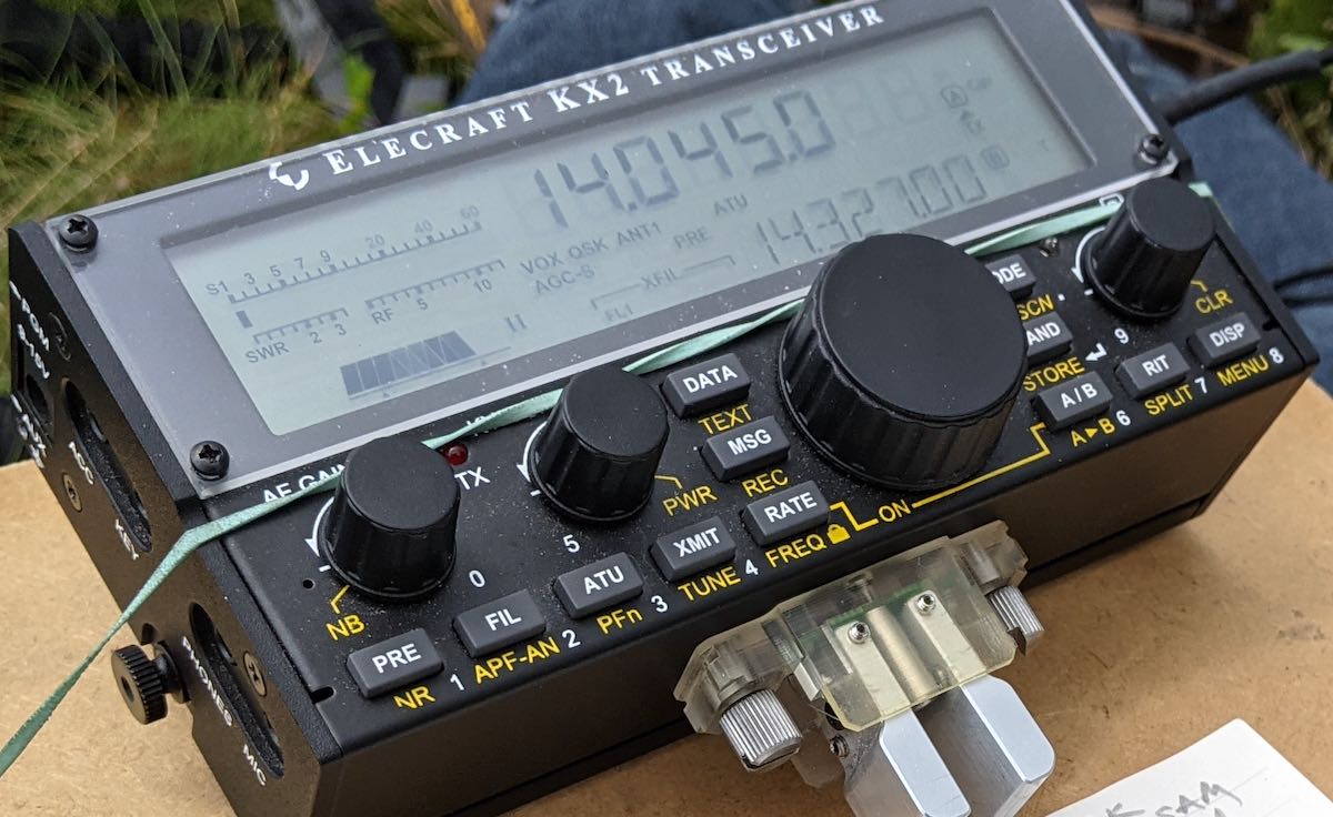
I originally thought I would use my EFRW mounted on a fishing pole for my SOTA activations. However, cleaning, stripping, and re-waterproofing the tent/rainfly took so much time, I didn’t follow through with a solution to support it on a summit with no woody vegetation. I opted to use the AX1 instead with the configuration Thomas has had the most success – mounted to the side of the KX2. I also took with me the counterpoises (20 and 40 meters) that came with the antenna.

Once on the air, I called CQ SOTA to make sure I worked those ops first given they are fewer in number than POTA hunters. Since the activation would count for both SOTA (Black Balsam Knob W4C/CM-003) and POTA (Pisgah National Forest US-4510), I gave my location (NC) for all exchanges. (I think SOTA just requires an RST.) I worked seven stations in ten minutes, a good rate.

Operating

I moved down one Hertz as I began faintly hearing someone else on the frequency. (Yes, I cleared it first; however, given I was operating QRP, fighting for the frequency was probably a losing battle.) It was at this point I began calling CQ POTA and the callers dried up. I did have cell service here and worked one park-to-park with Kenneth NS1C at US-11632 in Massachusetts. I continued to call CQ both on 20 and 17 meters with no luck. I didn’t opt to try 40 meters as I figured it wouldn’t be any better.

QSO map for Black Balsam Knob/Pisgah Nat’l Forest source: http://tools.adventureradio.de/analyzer/

About the time I had packed up my gear, Gary W5GDW contacted me asking about 40 meters. I was loathe to pull my equipment back out. He also advised me there was a solar flare. (Maybe that was why I suddenly didn’t hear anyone.)

At this point, I had a valid SOTA activation but not for POTA. I figured the campground at which I was staying – Davidson River Campground – is in Pisgah National Forest so I could finish my activation at my campsite later in the afternoon.

As I headed down the mountain, I began questioning whether I had actually reached the summit. Something didn’t feel right. I checked the map at the trailhead and noticed Black Balsam Knob has a plaque honoring Art Loeb and I didn’t recall seeing any such thing. Uh oh. Maybe I hadn’t had my first SOTA activation. My heart sank.

Map at trailhead for Black Balsam Knob

First of all, it was demoralizing I had botched my very first SOTA. Second, how humiliating because of how public it would be. Honesty is one of my values and I’d have to admit the mistake. I almost scrapped the remainder of the day I was so bummed. However, I didn’t drive all the way to North Carolina to scrap activations so onward I went to the next one – Richland Balsam – which would give me a SOTA activation and two POTA parks. Did I redeem myself? Stay tuned…

Equipment Used

[Note: All Amazon, CW Morse, ABR, Chelegance, eBay, and Radioddity links are affiliate links that support QRPer.com at no cost to you.]

My first SOTA activation with the new Elecraft KH1 handheld QRP transceiver!

On Friday, November 3, 2023, I had planned to activate Mount Mitchell–the highest summit in eastern North America. I need to activate Mitchell soon because I’ve yet to activate it for SOTA in 2023 and when winter weather sets in (quite early at that altitude) the park is inaccessible.

Unfortunately, last week, the National Park Service closed an 8 mile portion of the Blue Ridge Parkway due to (no kidding) park visitors feeding and trying to hold bears at the Lane Pinnacle Overlook.

I won’t get on my soapbox about how people are so out of touch with nature that they feel human interaction with bears is a good thing. It breaks my heart because as we natives of WNC say, “a fed bear is a dead bear.” Bears that become comfortable with humans become (at best) a nuisance and (at worst) aggressive.  This is bad for people and it’s bad for our bears who are otherwise shy and avoid humans.

Okay, I said I wouldn’t soapbox about this…

That 8 mile section being closed meant that what would have been a 50 minute drive to the summit of Mitchell turned into a 90 minute drive. Round trip, I simply couldn’t fit that in my day, so I made alternate plans.

Another summit on my list to activate before year’s end was Richland Balsam.

Richland Balsam is actually the highest summit on the Blue Ridge Parkway and is, in fact, at one of my favorite points along the parkway.

That  Friday morning, I dropped my daughters off at their classes and drove an hour or so to the Haywood-Jackson Overlook.

In the valley, as I started my drive to the parkway, past the Cradle of Forestry, it was 30F/-1C. I was concerned that on the summit–nearly 4,000′ higher in elevation–that the temp would be closer to 20F. Fortunately for me, as I gained elevation, the temperature climbed too. We were having inversion that day so the higher altitudes were actually warmer than lower altitudes. This is not uncommon in the fall and was very welcome that particular Friday morning!

Richland Balsam (W4C/WM-003)

Only three weeks earlier, there would have been no free parking spots at the Haywood-Jackson Overlook overlook–it would have been packed.

Fortunately for me, all of the leaf-lookers had gone and I literally had the place to myself. What a luxury!

And the temperature? A balmy 43F/6C.

The hike to Richland Balsam is one of the easiest along the parkway.

At the north side of the parking area, you’ll see a trailhead for the Richland Balsam Nature Loop Trail.

I wish my iPhone camera could haver truly captured how the moon looked in the sky.

The trail isn’t long; I believe the entire loop is just shy of 1.5 miles.

Although I didn’t set out to do this, I ended up making a video of the entire loop trail hike along with the activation (of course, you can skip over those parts in my activation video below).

Sadly, one thing you won’t be able to enjoy in my video? The smell. The air is filled with the fragrance of balsam trees along the entire trail–it’s just amazing!

The summit of Richland Balsam is at 6,410 feet ASL (1,954 meters).

The summit is covered in trees which is brilliant for SOTA activators. Another luxury is that there are two benches within the activation zone. I did pack my Helinox Zero chair as a backup, but didn’t need it.

SOTA with the KH1

Setting up my KH1 for a SOTA activation couldn’t be easier or faster. I show the whole process in my video at a very casual pace. Continue reading My first SOTA activation with the new Elecraft KH1 handheld QRP transceiver!

SOTA Activation: Richland Balsam with the Elecraft KX2 and Chameleon CHA MPAS Lite

Two weeks ago, my buddy Monty and I went on a camping trip near Mount Pisgah off of the Blue Ridge Parkway. It was amazing.

Monty is one of my best friends and like a brother to me.  We were roommates during my undergraduate years at Western Carolina University. In those days, we were both into mountain biking, hiking, trail running, backpacking, and camping. WCU was the perfect launching point for all of those activities.

These days, we both still do hiking and a little mountain biking, but at–what we might generously call–a more “relaxed” pace.

Although Monty’s family also live in western North Carolina and we keep in touch pretty regularly, we hadn’t seen each other in person for years, so we knew a camping trip would sort all of that out and give us a chance to reconnect while disconnecting from our busy schedules.

Mount Pisgah

You can’t see it in the photo, but my 25 year old four person dome tent about pushed Monty’s two person dome tent off of the camping pad! And, yes, I brought a butane torch to light the campfire–not exactly bushcraft.

We chose Mount Pisgah campground off of the Blue Ridge parkway for a few reasons: it’s roughly halfway between our homes, it’s at a high altitude which equates to cooler nights during the hottest part of the summer, and–you guessed it–it’s on no less than two POTA sites and close to a number of SOTA summits as well!

Another fun fact about the Mount Pisgah campground? It’s also black bear habitat. I believe I mentioned that when I activated Mount Pisgah earlier this summer, I spotted a number of bears in this area.  But hey! Check out the park’s bear traps:

And to be honest? My QTH is also just as much in black bear territory, so this isn’t exactly unfamiliar.

Richland Balsam (W4C/WM-003)

I was up earlier than Monty, so I brewed some coffee, read a bit of my book, and fit in a little early morning POTA!

The weather was ideal on the morning of Monday, August 2, 2021.

Monty actually mentioned in advance that he’d like to accompany me on a SOTA activation or two. He’s an engineer at WCU and I’ve been nudging him for years to get his ham ticket, so how in the world could I pass up a little SOTA/POTA proselytizing?

While Monty cooked up some breakfast burritos, we hatched a plan to activate Richland Balsam first.

Richland Balsam is a very accessible 6,410′ (1954M) summit and is actually the highest peak on the entire Blue Ridge Parkway.

Richland Balsam is a great “beginners” SOTA summit because the loop trail is only 1.5 miles long, well-marked, doesn’t require an experienced hiker, and passes through a spruce-fir forest which not only provides shade, but also ample trees for wire antennas. The trailhead is easy to find as well; it’s at the north end of the Haywood/Jackson overlook parking area.

Only one word of caution: being such an accessible loop trail right there on the Blue Ridge Parkway, it can get very busy during the summer and fall–in fact, you might struggle to find a spot to park.  Monty and I arrived early enough that there were only a handful of cars parked at the overlook.

Richland Balsam reminds me of some of the trails in/around Mount Mitchell:  lots of ferns, mosses, and and the smell of spruce-fir. Bliss!

On The Air

I’d forgotten that there are actually a couple of benches on the summit of Richland Balsam which is a proper luxury for any SOTA activator!

Monty had no issue at all setting up the Chameleon MPAS Lite vertical on his own as I prepared my clipboard, Elecraft KX2, and log book.

Gear:

I actually had decent mobile phone service on the summit, so spotting myself was quite easy via the SOTA Goat app. Of course, I assumed I might not have access to spot myself, so I did schedule the activation before leaving the campsite on both the SOTA and POTA platforms knowing both would auto-spot me from the Reverse Beacon Network (RBN).

I started calling CQ on 20 meters CW and my first contact was fellow POTA activator Steve (KC5F) who was, no doubt, working me via ground wave from his home. Always good to have Steve in the logs.

In thirteen minutes, I worked nine stations on 20 meters–lots of familiar calls. I actually validated the SOTA activation (logging four contacts) in no less than five minutes!

I then moved to 17 meters where I worked K6MW in Washington state.

Finally, I moved down to the 40 meter band in hopes of picking up Mike (K8RAT)–success!–and also worked good ole’ Bill (WB1LLY) in Georgia.

Here’s my full log sheet:

Near the end of the activation (you might note this in the video), Monty and I hear a loud animal noise in the forest–very likely a black bear making itself known. We took that as a cue to pack up and move on.

Video

Here’s my real-time, real-life, no-edit video of the entire activation from start to finish. If you’ve been seeking a cure for insomnia, you’ve found it:

Click here to view on YouTube.

A perfect day for hiking

The view from Black Balsam.

After leaving Richland Balsam, we decided to also take in W4C/CM-005 (Black Balsam Knob) which is another 10 point summit on the Blue Ridge Parkway. I tried making a video of this activation, but for some reason the camera shut down after nine minutes. I’m uncertain yet if I’ll publish that video with a post. We’ll see! It, too, was a fun activation.

After Black Balsam, Monty and I prepared a late lunch back at the campsite and decided that there was still enough of the day left to take in the Mount Pisgah summit trail. Frankly, it was simply too tempting! There was a trail not even 25 feet from our tents which lead us to the Mount Pisgah trailhead. Since I had already activated Mount Pisgah only recently, I didn’t take radio gear this time.

Turk’s-cap lilies were in bloom along the Mount Pisgah trail.

Funny, but we both underestimated the hike from our campsite to the Mount Pisgah trailhead. In my head, I assumed it was perhaps half a mile or so. Turns out, it was more like 1.5 miles one way!

The Mount Pisgah tower

Combined with the actual Mount Pisgah trail, it made for a decent amount of hiking. I believe we left the campsite around 16:00 local and were  back by 19:00 or so.

That Monday turned out to be a day full of hiking, radio, and hanging with Monty. It was amazing fun.

Thank you

As always, thank you for reading this report and thank you to those who are supporting the site and channel through Patreon and the Coffee Fund. While certainly not a requirement–my content is always free–I really appreciate the support.

Here’s wishing everyone good health and maybe even a little outdoor radio fun this week!

Cheers & 73,

Thomas (K4SWL)


Do you enjoy the QRPer.com?

Please consider supporting us via Patreon or our Coffee Fund!

Your support makes articles like this one possible. Thank you!