Many thanks to Teri (KO4WFP) for the following guest post:

An Unexpected, Speedy Activation at Tuscumbia WMA in Mississippi
by Teri (KO4WFP)
Some of the best things in life are unexpected.
My family, after spending two days in Dallas, Texas visiting in-laws, headed back east on Wednesday, July 26. We originally planned to drive Interstate 20 through Louisiana and Mississippi with a stop in Alabama to visit with friends. However, early Wednesday morning, I Googled our route and realized a shorter route through Arkansas and Mississippi would save us thirty minutes. That doesn’t sound like much but when you spend nearly all day driving in a car, thirty fewer minutes feels like a big deal.
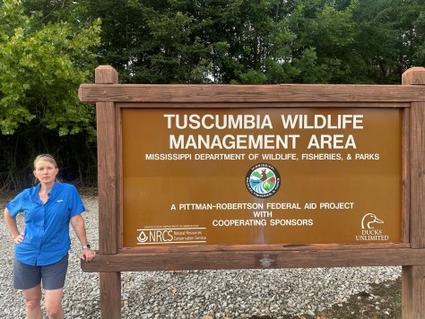
Before the trip, I planned an activation in and purchased a permit for Louisiana’s Russell Sage WMA (K-4076). Well, now I wouldn’t even go through Louisiana on our way back. I was loathe to not activate a park at all on the drive home. (Those who know me well, know I don’t give up easily at anything.) So I looked at the new route and the POTA website and endeavored to find a park that would work as well as we’d reach later in the day due to the hot weather. I settled on Tuscumbia Wildlife Management Area (K-7092) in Mississippi along US Route 72.
The 2,600 acre Wildlife Management Area (WMA) is located just outside Corinth, Mississippi and divided into two sections, one on either side of US 72. The section to the north of the highway is primarily swamp bottomland but the northeast corner of it is accessible to the public. The WMA is a great place for birding and I noted 104 species have been observed according to the website eBird. It was this northeast corner at which I would attempt my activation.
The weather during the day was hot! At the Arkansas welcome center, I noted the boat-tailed grackles in the parking lot panting to cool off in the heat. I planned to reach Tuscumbia WMA near the end of the day but whether it would still be too hot or not, I had no idea. Thankfully, as we reached the Mississippi state line out of Memphis, cloud cover appeared and I watched the temperature on the dashboard slowly descend from 99 degrees earlier in the day to a manageable 86 degrees.

The other potential wrinkle in my last-minute decision was whether accessing the park required a fee or not. I couldn’t tell from the Mississippi Department of Wildlife, Fisheries and Parks website. When we reached Memphis and had better cell service, I called one of their offices and spoke to a helpful employee who confirmed that yes, I would need a permit which I could purchase using their app. I also needed to use a second app to check in and out when actually at the park. Somehow I managed to get the apps downloaded, my account set up, and a one-year non-resident permit purchased during my husband’s turn at the wheel. Whew! One more hurdle surmounted.

Everything seemed to be falling into place. The last remaining wildcards were if I would arrive early enough before sunset and would I be able to find a place to set-up.
We arrived at the site a little before 7 PM. The most obvious place to activate, on the gravel pad next to the highway, had power lines running right above it as I had feared. There was no way to set up there. And I could not drive the car further into the property as gates prevented auto access. My only other option, with daylight running out, was to walk into the property, find a spot, and sit on the ground. To make space for our trip luggage, though, I left behind the bin in which I usually keep a tarp and other emergency supplies. (Note to self – next time keep at least a tarp in the car.) The only thing I could find for me to sit on was the windshield sunshade – not ideal but it would work.


I checked into the app, grabbed my POTA backpack, liberally applied bug spray for the gathering mosquitos, and headed past the gate to see with what I had to work. By the way, I’ve never seen mosquitos so large in size! They were at least three times bigger than the ones we have in Savannah, GA. Continue reading KO4WFP: An Unexpected, Speedy Activation at Tuscumbia WMA in Mississippi →