Tag Archives: POTA Pooches

K3ES Field Report: Hiking with Molly and discovering a new two-fer activation site!

Many thanks to Brian (K3ES) who shares the following field report:


Molly is on the trail of a POTA activation.  Temperatures are in the 40s, but there is still snow on the ground.

A Hike and a 2-fer

by Brian (K3ES)

When you live in northwestern Pennsylvania, and a February day shows up with the sun shining, moderate temperatures, and nothing pressing on the calendar, it is time to go and enjoy the outdoors.

One of the best ways to do that is to take a hike with your dog.  Hopefully  your dog is like Molly, who doesn’t mind taking a break mid-hike for a Parks on the Air (POTA) activation.  So on Wednesday, February 21 we scheduled an activation and jumped in the truck for a drive to the trail head.  The hike to and from the activation site would be a nice change from the short walks we had been taking to the pond behind our house in the colder weather, and from activating while sitting in the truck.  And, to better share the joy with our POTA hunters, we would make this activation a 2-fer, giving them credit for both the North Country Trail National Scenic Trail (K-4239) and Pennsylvania State Game Land 024 (K-8725).

Molly is ready to go.  She is not at all amused by waiting for me to take pictures.

Since I had hiked the planned route before, both solo, with friends, and with Molly, I expected that the route would be familiar.  Some of it was, and some of it was brand new to us.  You see, the North Country Trail volunteers had been busy since we last hiked as far up the trail as we planned to go.  They had cleared and marked an entirely new route for one section  of the trail, bypassing an old favorite activation site!  So, we got to do some exploring, and we found a new favorite activation site.  Bonus!

Finding a New 2-fer Site

One of the things that I enjoy about POTA is planning my activation.

Since days long ago as a Boy Scout, I have enjoyed outdoor navigation.  Map and compass always fascinated me.  Things have gotten much easier with Global Positioning System (GPS), online maps, and online satellite imagery.  Still, I do most of my activation planning while sitting comfortably at home with a tablet or a computer.  For this trip, finding the newly marked trail (that had not yet been transferred to the online map) presented a bit of a challenge.  While I could follow the marked trail easily, I needed to be sure that I had entered Game Land property so that the 2-fer activation would be valid.

Thankfully, I had access to an app on my smart phone to help me solve this problem as we walked along the trail through the woods.  The On X Hunt app combines GPS, topographic maps, satellite imagery, and tax office databases to identify land ownership (even when the owner happens to be the Commonwealth of Pennsylvania).  Full functionality of this app is not free, but as the owner of a parcel of land, it is something I had elected to pay for.  Once it became clear that the newly marked trail would not quickly rejoin the prior route, I set up the app to record our track on the map.  After confirming that Molly and I had definitely crossed PA Game Land property line (there were no marking signs along the new trail), we went just a bit further, then found a promising spot to set up for the activation.

With a change to the K-4239 North Country Scenic Trail route, we found a new 2-fer site within K-8725, along the partially snow-covered Game Land road that carries this section of the Trail.

Setting Up to Activate

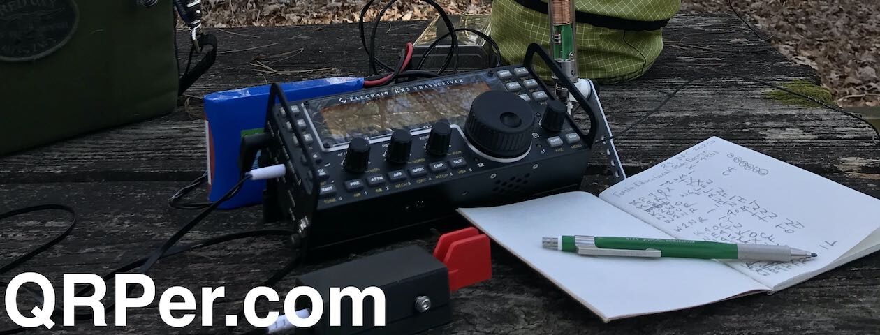
I chose to locate our station in the woods beside a Game Land road that provided the path for the North Country Trail in that particular area.  We set up on the inside of a bend flanked by trees with long overhanging branches.  I placed my chair in the woods on the inside of the bend, and tossed a throw line over a branch on the outside of the bend, then deployed my Packtenna EFRW with 71 ft wire as an inverted V across the road.  I used the throw line to hoist the middle of the radiating wire up about 30 ft, and secured both the feedpoint and the far end of the antenna to nearby trees, about 6 ft off the ground.

Even though I did not expect traffic on this road (shaded areas were still snow covered, and the snow showed tracks only from woodland creatures), I try to deploy my wire antennas high enough that they are not a hazard to others who may travel through.

Temperatures were rising, but with the high only expected to hit 50F, I brought a blanket to give Molly some additional insulation (though she is a rough, tough POTA dog, as a Boston Terrier, her coat is not particularly thick).  I laid out the blanket beside my operating position,  so that it could provide both top cover and insulation from the ground.

Molly is settled in for the activation.

I connected my RG316 coaxial cable to the antenna feedpoint, set up my camp chair next to Molly, set up the radio, and prepared my log book. In very short order, I was on the air, spotted by the Reverse Beacon Network, and logging contacts. Continue reading K3ES Field Report: Hiking with Molly and discovering a new two-fer activation site!

Exploring the Mountains-to-Sea Trail: QRP POTA with Hazel and a New KX1 Kneeboard!

On Friday, January 5, 2024, I looked at Hazel and could tell that, despite the chilly temps, she wanted to go on a late afternoon hike. I did, too, for that matter and why not combine the hike with a POTA activation?

In addition, we were expecting a winter storm to move in that night, so hitting the trail in advance of the snow and ice seemed to make sense.

Before I could get my boots on, Hazel was waiting by the car door to jump in.

Mountains-to-Sea State Trail (K-8313)

One of the closest long trails near my QTH is the Mountains-to-Sea Trail (MST).

At 1175 miles long, the MST stretches from the Outer Banks of North Carolina to the Great Smoky Mountains (see map above).

I can actually hike to the MST from my QTH, but it takes a good hour and half to do so. It’s much easier to drive to one of the numerous nearby trailheads, and that’s exactly what Hazel and I did. I drove to one of my favorite Blue Ridge Parkway POTA spots where a short manway connects to the MST.

Hazel was so excited to hit the trail. (I was, too.)

At the end of the day (because, it was nearing the end of the day) we couldn’t hike for long if I planned to also complete a POTA activation. Sunset was at 5:29 PM local and I didn’t want to pack up and hike back in the dark.

That said, if I needed to hike back in the dark, I could have because I never go on a POTA or SOTA activation without a fully-charged headlamp. FYI: I was packing a NiteCore NU25 (affiliate link).

I started my action camera and captured the last bit of hike before Hazel and I found a great spot to set up. There were enough trees around to deploy a 40 meter EFHW and a relatively flat spot to set up my Helinox chair and KX1 station.

Since much of this section of the MST is on the Blue Ridge Parkway grounds, I checked quickly to make sure my operating site would qualify as a two-fer with K-3378.

I opened the Parceled App on my iPhone to confirm that my site was indeed on Blue Ridge Parkway property..

A KX1 Kneeboard!

If I’m being perfectly honest, I had an ulterior motive with this trailside activation: I was eager to finally put my new KX1 kneeboard into use! Continue reading Exploring the Mountains-to-Sea Trail: QRP POTA with Hazel and a New KX1 Kneeboard!

WD8RIF takes his dog and his KX2 on a bicycle-portable POTA activation

Many thanks to Eric (WD8RIF), who shares the following field report via his website WD8RIF.com:


by Eric (WD8RIF)

On Saturday, November 4, 2023, I performed a successful bicycle-portable two-fer activation of Lake Hope State Park (K-1968) and Zaleski State Forest (K-5455) in Ohio as part of the Parks on the Air (POTA) program.

On a beautiful and warm early November afternoon, I bicycled the Moonville Rail Trail, on what used to the Marietta and Cincinnati Railroad (wikipedia article) right-of-way, from the tiny village of Mineral, through Zaleski State Forest, diverting from the rail trail near Lake Hope to ride to the Mountain Bike Trailhead overlooking Lake Hope within the state park, for my two-fer activation of the state park and state forest. I was carrying my KX2 Mini Travel Kit on the bicycle, and I was pulling my little dog Theo in a trailer behind the bicycle.

From the Moonville Rail Trail website:

This 10-mile rail trail takes visitors through the beautiful woodlands of southeast Ohio, including Zaleski State Forest; the communities of Zaleski and Mineral; and the Lake Hope State Park wetland areas. The corridor holds water on both sides of the trail, creating a wetland area that is home to numerous species of flora and fauna.

Additional points of interest along this trail are two unique and historic tunnels. King’s Hollow Tunnel (also known as King Switch Tunnel) is a 120-foot structure carved through the rock and lined by a series of 12×12 wooden beams. The Moonville Tunnel is brick-lined and has a long history of train accidents, earning the tunnel a reputation for being haunted.

After parking my car at Mineral, I began my ride on the leaf-covered Moonville Rail Trail at 1645 UTC and soon encountered the first landmark of the ride: the 120′ long, timber-lined King’s Hollow Tunnel.

Leaf-covered Moonville Rail Trail
The leaf-covered Moonville Rail Trail,near Mineral
King's Hollow Tunnel
Entering King’s Hollow Tunnel
King's Hollow Tunnel
Exiting King’s Hollow Tunnel

Riding through the very dark tunnel and continuing west on the Moonville Rail Trail, I soon came to a succession of ponds. Rumor has it that a pair of nesting bald eagles fish these ponds, but I have yet to see them.

Ponds along the Moonville Rail Trail

Ponds along the Moonville Rail Trail
A small bit of railroad history along the Moonville Rail Trail.
Leaf-covered Moonville Rail Trail
More leaf-covered Moonville Rail Trail

Continuing west, and now being well inside Zaleski State Forest, I soon came upon the brick-lined Moonville Tunnel.

Moonville Tunnel

Moonville Tunnel
Entering Moonville Tunnel

After passing through the Moonville Tunnel, I was forced to divert from the Moonville Rail Trail and follow a gravel road before re-joining the Moonville Rail Trail about a mile further on. (When CSX abandoned the rail line in the early 1990s, they took everything: rails, ties, ballast, and all the bridges. Two of the bridges west of Moonville Tunnel have yet to be replaced.) I was pleased that my new narrow knobby bicycle tires were reassuring on the rough gravel road, but I can’t say Theo in the trailer enjoyed this portion of the ride much.

Back on the Moonville Rail Trail, and continuing west, the rail trail was almost 100% leaf-covered. Continue reading WD8RIF takes his dog and his KX2 on a bicycle-portable POTA activation

Brian Activates Allegheny National Forest and Remembers a Dear Friend

Many thanks to Brian (K3ES) who shares the following guest post:


Activation at Allegheny National Forest:  Remembering a Friend

by Brian (K3ES)

The last few weeks have been rough for the K3ES household.  In past activation reports, I introduced you to our two Boston Terriers.  Molly and Jojo came to us as rescue dogs in October 2022, and we have worked hard to help them feel safe and loved.  Unfortunately, both came to us with unexpected health problems.  We were able to get Molly through treatment for heartworm, and she is thriving.  Jojo always had something holding her back, but we were never quite sure what.  We lost her just before Christmas, and that was a real punch in the gut.

Jojo was a special dog.  When we brought her home, she barely weighed 15 pounds.  Even after we managed to build her weight up to 25 pounds, she was still thin for her frame.  She also came to us hunched, cowering, and emotionally traumatized.  It took months for her to start coming out of her shell.  We got glimpses of her as a feisty, and loving dog, who took real joy from laying in the sunshine.  We were hopeful that she would one day come into her own, and give our jubilant Molly a real run for her money.  Sadly, it was not to be.  She had increasing problems with mobility.  We treated her for a bone infection, for possible tick-borne disease, and for joint inflammation.  Steroids and pain medication helped her quality of life a lot.  It was only near the end that the likely culprit was identified as cancer, but even expensive diagnostic tests failed to confirm that.  Finally, her body just crashed, and we had to let her go…

Jojo supervises a truck activation of Allegheny National Forest in March 2023.

Looking back through pictures of Jojo, I discovered some that were taken during a never-reported “truck activation” of Allegheny National Forest (K-0619) back in March, 2023.

I have never thought that my vehicle-based activations were terribly interesting, so I never spent the time to report them.  Suddenly, that particular activation held new meaning, because one of the few times I got Jojo out with me for a POTA activation happened because I was doing a low-impact drive-up, working from the truck.  She rode shotgun, and sat happily in the passenger seat while I made contacts.  Molly sat in the back seat, napping from time to time.  After the radio gear was packed away, the three of us even managed to take a short trail walk along a Forest Service Road that starts at the parking area.

Jojo and Molly lead the way on the Forest Service Road after the radio gear was packed away.

Last week, I found myself in serious need of radio-therapy.  Since Molly is always ready to go for a ride and a POTA, I decided to take her along to re-create the prior activation that we did with Jojo.  So this is the story of our salute to a departed friend, a tribute activation, as it were.

Activation

Molly and I packed her blanket, picked up my KX2 field kit, and jumped in the truck for a 20 minute drive to the trail-head parking area that we had activated with Jojo last March.  It has trees, a decent driving and walking surface that would not be too muddy from recent rain, and the Forest Service road where we had walked after the previous activation.  This time, Molly rode in the passenger seat, alternating between napping, and looking at the scenery as we drove.  Upon arrival she stayed put, while I used a throw line to put up my Tufteln 35 ft EFRW as a sloper.  I hooked the unun around my 2 meter mobile antenna, and ran coax into the truck through the lower part of the driver-side door seal.  I set up the KX2 on the center console/armrest, prepared my log, and got on the air to start the activation.

Tufteln 9:1 unun was clipped to my 2m mobile antenna, with the 35 ft radiator sloping up to a tree, the 17 ft counterpoise dropping down to the ground, and the RG316 feedline leading into the truck.

Results

As with almost all of my activations, I ran this one entirely CW QRP.  Beginning just after 1900z (2 pm local), I decided to start on 15m and work my way down the bands.  The HF bands were in good shape, and 15m netted 2 quick contacts, then 17m yielded 6 more.  The pace picked up when I moved to 20m (12 contacts in 22 minutes), and got even faster on 30m (17 contacts in 19 minutes, before it was time to call QRT).  While I was on the air, Molly did some supervising and some super snoozing.

Molly is an interested supervisor…
But supervising is tiring work.

Working steadily for an hour and a quarter, and finishing with 37 contacts was just the kind of break that I needed.  I want to sincerely thank the hunters who made this activation a success.  For just a short while, I was focused on CW, call signs, and signal reports, and the sense of loss receded a bit from my consciousness.

A map of 37 contacts on 4 bands.

Equipment

[Note: All Amazon links are affiliate links that support QRPer.com at no cost to you.]

Molly and I walked along the Forest Service Road.  We felt incomplete…

Conclusion

After I packed up the station, Molly and I repeated our walk along the Forest Service road.  With just the two of us, it was definitely a bittersweet experience.  I think Molly felt our loss, too.  I like to think that Jojo would have been fine with missing this activation.  The weather, while not raining, was cool, overcast, and a bit gloomy.  The sunshine that she treasured was absent for us that day.  Hopefully, she has found a place in perpetual sunshine, and is soaking up the rays.  Good bye sweet pup.

We will always remember Jojo in her natural element, bathing in sunshine…

Hold on tight to those you love, and do something special with your four-footed companions.  I wish you all the best in 2024.

Best 73 de Brian – K3ES