 Dear QRPer readers:
As you likely know, my activation reports typically run a few weeks behind. Although I’ve got several in the pipeline, I pushed the following report to the front of the line.
You might brew a cuppa’ coffee or tea for this one.
Here’s wishing you and yours very Happy Holidays and Merry Christmas!
73,
Thomas (K4SWL)
A Special Holiday Activation
As mentioned in my previous activation report, we’ve spent the past week on the Outer Banks of North Carolina; specifically, Hatteras Island.
It’s been amazing.
If you’re not familiar, the Outer Banks (OBX) is a 200-mile (320 km) long string of barrier islands off the coast of North Carolina and southeastern Virginia that separates the Pamlico Sound, Albemarle Sound, and Currituck Sound from the Atlantic Ocean.

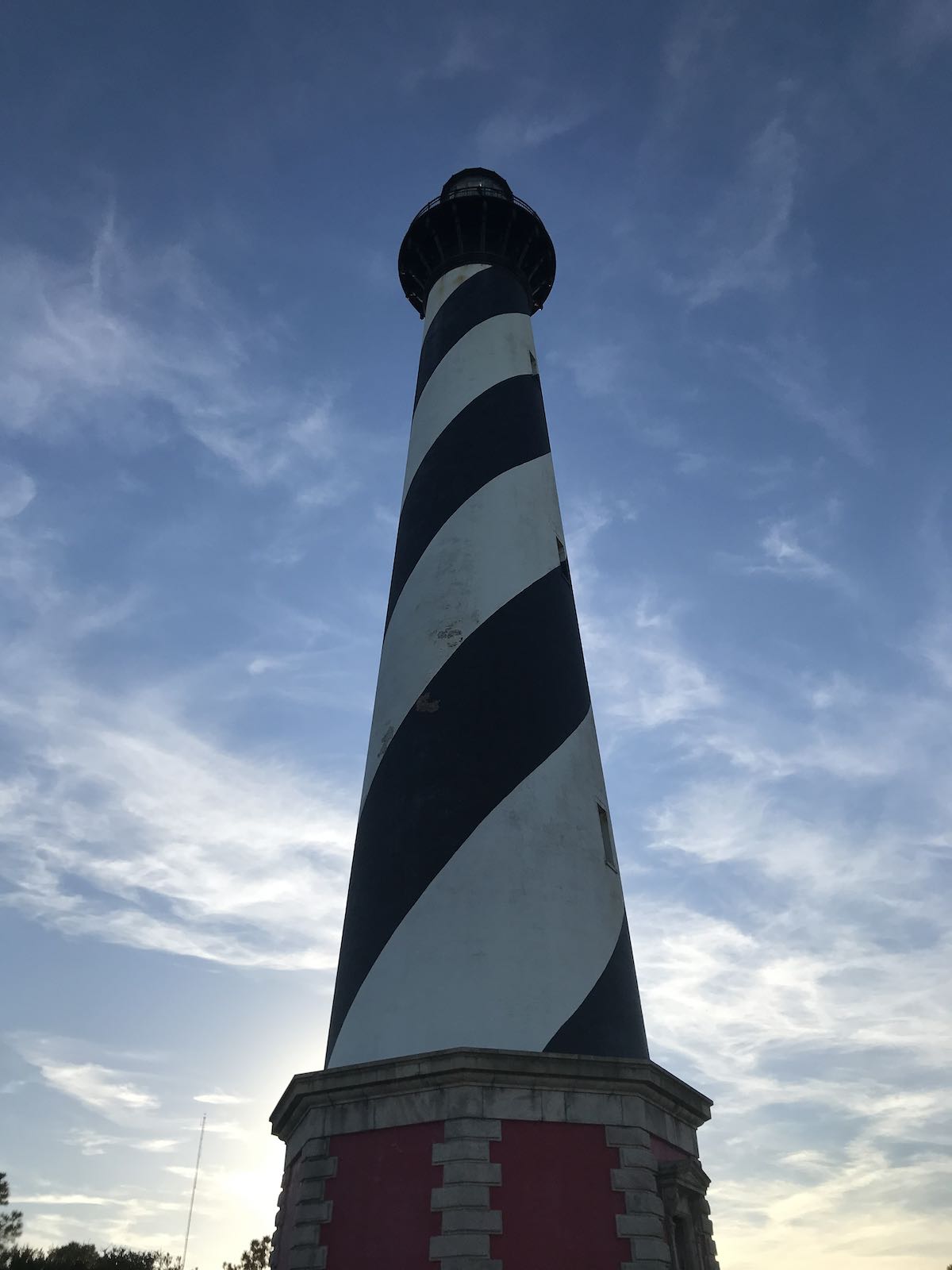
No trip to the Outer Banks would be complete without visiting North Carolina’s most iconic structure: the Cape Hatteras Light Station in Buxton, NC.
Cape Hatteras Lighthouse
 On Thursday (December 16, 2021–last week) the weather was stunning, so my family took a few long walks on the beach, explored Hatteras Island, and spent the afternoon at the Cape Hatteras Light Station which is located within the Cape Hatteras National Seashore.

The Cape Hatteras lighthouse is a North Carolina icon and arguably one of the most recognizable lighthouses in North America due to its height, its age, and the black/white helical daymark paint scheme.

The Cape Hatteras Lighthouse is the tallest brick lighthouse in North America standing at 210 feet. In fact, it’s the second tallest brick lighthouse in the world–second only to Świnoujście Lighthouse in Poland.
The Cape Hatteras Light Station has played an important role in protecting ships from becoming casualties of the Diamond Shoals off the coast of Cape Hatteras. This area, where the Gulf Stream current collides with the Labrador Current can not only produce some impressive storms but the shifting sands of the Diamond Shoals have taken down so many vessels it has been nicknamed “The Graveyard of the Atlantic.”
The original Cape Hatteras Lighthouse was constructed in 1802, but in 1868 Congress appropriated funds to build the second, much taller brick lighthouse.
As it turned out, our visit to the the Cape Hatteras Lighthouse on Thursday, December 16, 2021 was exactly 150 years–to the day–from when it was first put into service on December 16, 1871.
Pure serendipity.
On the move
 Believe it or not, in an amazing [understatement] feat of engineering, the Cape Hatteras Lighthouse was relocated in 1999 due to the waters of the Atlantic Ocean encroaching on the site.

The lighthouse was moved a total distance of 2,900 feet (880 meters) southwest to its current location. Click here to read more details about the move.
Strong radio roots
 Cape Hatteras has a very strong radio connection as the Reginald Fessenden performed early radio voice experiments on the site. Per the National Park Service:
Born in Canada, Reginald Aubrey Fessenden was a premiere radio pioneer and considered by many to be the “Father of Voice Radio.” During his life, he unleashed the potential of several concepts and applied them in ways that are taken for granted in the present-day. In pursuit of a successful system to transmit and receive the sound of voice using continuous waves, Fessenden found himself experimenting on Roanoke Island and the surrounding region for 18 months from 1901 to 1902.
Working as contractor for the U.S. Weather Bureau, Professor Fessenden’s stage of research by this time involved constructing an efficient continuous-wave transmitter and also improving signal reception with a continuous wave-detector. Based on Roanoke Island, he erected 50-foot tall radio towers at Weir Point on Roanoke Island, Cape Hatteras, and Cape Henry to conduct his research.
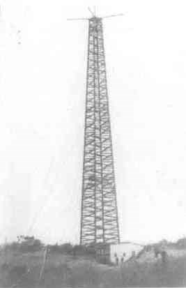
By March of 1902, Fessenden had demonstrated a successful transmission and reception of voice with the devices he had created. A 127-word voice message was sent from the Cape Hatteras transmitter tower to Roanoke Island. As word of his success spread, a conflict arose between the inventor and the Weather Bureau. Employing Fessenden as a paid contractor, the Weather Bureau wished to own the ideas. This was unacceptable to the professor and he resigned his contract by August of 1902 to continue his research independent of the Weather Bureau.
By Christmas Eve of 1906, his system had been refined to make the first public demonstration of a voice radio broadcast.
For a simulation of the first voice radio broadcast, go to: http://www.hammondmuseumofradio.org/fessenden-2006-recreation.html
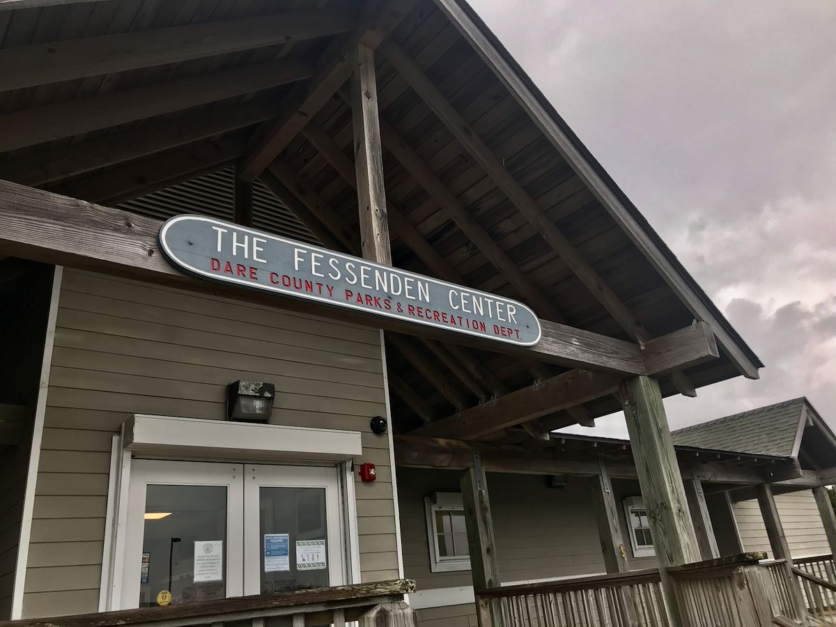
Locals have always been proud of this connection with Reginald Fessenden and, indeed, named their nearby county recreation center after him.
I’ll be honest: I was not aware of this connection to Reginald Fessenden, so it was fascinating for me to learn so much more from the park staff and my reading after returning home.
Plotting an activation
 After exploring the grounds of the light station, I mentioned to one of the park rangers that I was an amateur radio operator involved with the Parks On The Air program and that I planned to do a number of activations along the Cape Hatteras National Seashore. He mentioned that a group of radio operators had actually been to the site the previous week and set up their gear at the end of the park’s parking lot, close to the beach.
I asked if it would be possible to do an activation on the grounds, near the museum and next to Cape Hatteras lighthouse. I was then introduced to Park Ranger, Matthew, who gave me his card and asked if I would send him an email describing the activation and the gear I would be using so that he could seek permission from the appropriate person within the NPS.
That evening, I wrote a detailed note asking for permission to do both the activation and shoot my real-time, real-life activation video. A few days later, I received a very kind reply and permission to do so with the on-site guidance of a park ranger. Woo hoo!
Asking permission
Important side note here: I’ve mentioned before that you don’t necessarily need to seek permission to do activations at each and every national or state park you visit. In general–though this varies state to state–if you’re planning to activate a park that’s primarily a rural recreational site with camping and loads of day use activities, you probably don’t need to ask for permission unless you’re planning a very long and conspicuous special event. This is especially true for parks that cover vast tracts of land and ones that have been activated heavily in the past (check the POTA and WWFF websites for history).
It is a completely different story for smaller, high traffic, high-density parks and especially those with historic and archaeological missions.
I would never consider activating a site like the Cape Hatteras Lighthouse without first seeking approval.

You might even think that with a simple tabletop antenna like the Elecraft AX1, it might not be necessary to seek permission, but keep in mind that the National Park Service staff also try to protect visitor viewsheds. They want every visitor to experience a site’s beauty without any obstructions or distractions.
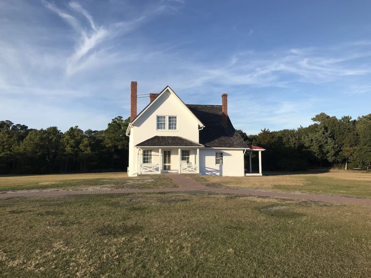
In my permission request, I described my radio gear, the power output and modes I would be using, and how long I planned to operate. I detailed two antenna options: the Chameleon CHA MPAS Lite vertical and the Elecraft AX1. I mentioned that my preference would be to use the MPAS Light but I would need to insert a short steel spike in the ground to support it. After seeing the MPAS Lite in person, the park ranger on site agreed that it was perfectly fine and he also agreed with the particular location where I preferred to set up next to the Lightkeepers’ house/museum.
Cape Hatteras National Seashore (K-0682)
One of the reasons I wanted to set up next to the lightkeepers’ house/park museum was because I knew it would be well outside the light station viewshed and both the house and the nearby brush and trees would provide a bit of a wind break.
On Monday (December 20, 2021) winds very gusty.

I brought my SOTA pack containing both the Elecraft KX2, Icom IC-705, Elecraft AX1, Chameleon CHA MPAS Lite (with 50′ coax), and even my folding three-leg stool. I didn’t need all of this, but I wanted options.
There were two glaring omissions however: my Muji Logbook, and my KX2 kneeboard!
Earlier that day, I pulled the kneeboard out to wash the little rubber pad that secures the KX2 and I pulled the logbook out to transcribe my manual logs (from an earlier activation on Ocracoke Island) into a digital log that could be uploaded to the POTA website. I left the rental cottage in such haste, I forgot to put them back in. That’s the first time I’ve ever forgotten a paper log book.
No worries, though–time to improvise! One of the park rangers gave me a sheet of paper I could log on if needed and I also used my Spec-Ops EDC Pack as a lap table for the KX2.
Using the backpack on my lap actually worked out quite well because it allowed me to include the light house in my video as I did the activation.
Gear:
- Elecraft KX2 and KXPD2 Paddles
- Chameleon CHA MPAS Lite
- Koh-I-Noor 2.0 mm Mechanical Pencil (affiliate links)
- Spec-Ops Brand T.H.E. Pack EDC

Something else this omission gave me an opportunity to try: logging directly to my HAMRS app and simply skipping the paper log.
I wasn’t sure if I could pull it off because when I copy CW, my brain expects me to be holding a pencil! Turns out, though, I had nothing to fear: logging directly to the app worked fine.
I’m still a firm believer in keeping a paper log even if you’re live-logging to a logging application. Why? If your laptop/tablet/phone crashes unexpectedly, you’ll still have a backup of your contacts. (I’ve seen so many POTA and SOTA activators try to reconstruct lost logs via discussion groups–no easy task.)
Plus, I really like having paper archives of my activations–that’s just me, though.
I felt comfortable logging to the app without paper logs that day because I was also making a real-time video of the entire activation. If necessary, I could watch the video and very accurately recreate my logs.
On The Air!

I had previously scheduled a blanket activation of the Cape Hatteras National Seashore on the POTA website. That one scheduled multi-day post covered me for automatic Reverse Beacon Network spots anytime I hopped on the air and started calling CQ during the holiday. That is, as long as the RBN functionality was working correctly.

I started the activation by calling CQ on 20 meters in CW and started logging stations almost immediately. Within ten minutes, my 5 watts had already snagged the 10 contacts needed for a valid park activation.
I worked a total of 12 stations on 20 meters, then I moved to 40 meters CW and worked five stations. I quickly discovered that band conditions were pretty unstable–fading (QSB) was deep.

I then moved to 30 meters and worked six additional stations in CW.
Next, I moved to the phone portion of the 40 meter band and spotted myself to the POTA network (the RBN doesn’t catch voice contacts). I only made one contact on 40M SSB. I’m sure if I had moved frequencies and had been more persistent, I would have eventually racked up quite a few contacts, but I did have a bit of time pressure involved knowing that the park was soon to close.
Purely for fun, I then moved to the 60 meter band in CW and worked two more stations.
At the end of the activation, I had logged 26 contacts. Here are my logs:

QSO Map
Here’s what my QRP activation of Hatteras looked like plotted on a QSO Map (click to enlarge):

Activation Video
Here’s my real-time, real-life video of the entire activation:
Click here to view on YouTube.
ARLHS USA 119
 It didn’t cross my mind before starting the activation that I should also research and spot myself with the Amateur Radio Lighthouse Society. Because of this, I did not hand out their designator for Hatteras (ARLHS USA 119) in my exchanges.
I reached out to the ARLHS and they informed me that while they prefer the designator be given during the exchange, it was fine to confirm this with any chasers who need the ARLHS credit.
At the end of the day, no one chasing me knew I was sitting next to the Cape Hatteras Lighthouse. I literally activated the site within the same hour I received permission from the NPS as it was my last possible day to complete the activation. Next time, I’ll plan this out in advance as I quite enjoyed the experience of activating a lighthouse!
A very memorable activation!
 I’d like to thank the staff at Cape Hatteras Light Station for allowing me to perform this activation. The park rangers and volunteers couldn’t have been more informative and helpful.
I’m especially grateful to Park Ranger Matthew who helped facilitate the whole process. I think I might have even convinced Matt to get his amateur radio license–he showed a lot of interest in what I was doing during the activation and also noted that he would like to enhance his emergency communications skills. [Matt: if you happen to be reading this, reach out any time. I’m happy to help you along the way!]
Thank you!
 I hope you enjoyed this rather lengthy field report.
As I’ve mentioned so many times before, I enjoy writing field reports because they feel like travelogs and I enjoy sharing them.
I’d like to send a special thanks to those of you who are supporting the site and channel through Patreon and the Coffee Fund. While certainly not a requirement as my content will always be free–I really appreciate the support. It’s the gift that keeps on giving, and I’m most grateful!
Patreon and coffee fund supporters actually helped fund this family trip to the Outer Banks. It’s one way my family directly benefits from the energy I put into QRPer and my videos. It’s a pure labor of love, so it’s truly a win-win for all involved.
Also, I’d like to wish each and every one of you Happy Holidays and a Merry Christmas.
No matter how you enjoy this season of festivities, I hope it’s meaningful and enriching.
I’m so appreciative to all of you–thank you so much!
73,
Thomas (K4SWL)
Merry Christmas, Thomas to you and yours !!
Merry Christmas, Edward!
Excellent article and an exciting activation! Glad things went so well and that the Park Service was so accommodating! Cheers!
Thank you so much, Robert!
I’ve operated from a National site and as part of my permission to operate, I included phots of my antennas and equipment. Sent pictures of all antennas to find out which one they felt was my less intrusive option to others and environment . Merry Christmas Thomas to you and your family.
That’s a brilliant idea! I did share a link to a similar activation so they could see the setup. The more info, the better, I say! Thank you, Jim and Merry Christmas, OM!
Merry Christmas!
Merry Christams, Costin!
Great write up Tom. I have never been East of Nashville and always love your write ups. I think this might be at the top of my favorites. Merry Christmas to you and your family.
W0HL
Thank you so much, Dennis! Merry Christmas to you and yours!
Excellent article and fun activation, I love it..
I wish you and your family, all the very best for 2022.
Have a very nice and safe Seasons greeting.-
73 Mike VE2TH
You too, Mike! Here’s wishing you and yours a very Happy Christmas. I hope to make it to VE2 land next year to do some activations and pass my Canadian ham exam!
Cheers,
Thomas
So kewl, thank you for sharing.
I look forward to the time I have a KX2 to take it to the field, though my UBitx and QCX-mini work well for now.
Merry Christmas to all!!
73, WB8YXF
Merry Christmas, OM, and thank you!
Thanks, Thomas! Loved all the history, especially the pioneering radio connection!
73
W4LTC
Thank you, Bill!
Fassenden also had strong roots in Bermuda:
http://vp9ge.com/vp9f.htm
I also happened to go to school at Whitney Institute! The event in that story also happened to be partly run by my Physics teacher at Bermuda College (a non-ham).
I didn’t know of his NC connections.
Very cool, Paul!
Hi Thomas, a great post as always. Your post brought back some amazing memories from my childhood when we were living in Gloucester VA from 1960 to 1965. In 1964 we did a trip to cape Hatteras and saw that beautiful lighthouse. My father had been an oceanographer and had always been interested in that part of the eastern seaboard. I living in Virginia, and digging for minie balls from the Civil War was very interested in the ironclads, monitor and Merrimac that fought that famous battle at Hampton roads in 1862. So what some of your subscribers may or may not know is the monitor was lost of cape Hatteras in a major storm. I think the ship was located a few years ago with the turret identifiable. Thanks again for your posts, happy Christmas and New year to you and all your subscribers. Vy 73, VE1RNM
Great write up and a really enjoyable read.
When you mentioned it had been moved it triggered a memory so I looked the move up on the web. I am sure there was a documentary made which was shown on one of the channels over here about the lighthouse move. It was a pioneering project at the time.
Glad you had a successful activation and Merry Christmas to you!
It was on PBS (but I don’t think it was Nova)…….
What a great place for an activation! Thanks for the interesting report and Merry Christmas to you and your family, Thomas!
Nicely done! I also appreciate the contact. Thank you… John (AF8E)
Merry Christmas Thomas to you and yours. Thank you for what you do. You are such an inspiration.
Thank you so much, Robert! Very kind of you.