
Elecraft AX3 Field Report
By: Conrad Trautmann (N2YCH)
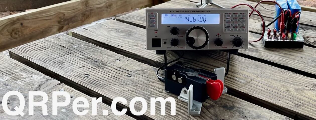
My new Elecraft AX3 antenna arrived in the mail. The weather when it arrived was 73° F and sunny with a slight breeze. Space weather was calm. It seemed like the perfect recipe for a POTA expedition to the unofficial antenna testing range at Silver Sands State Park (US-1716) here in Connecticut on the Northern shoreline of Long Island Sound to try out the AX3. Given that this antenna is specifically designed to be light and portable, I chose my Elecraft KX2 to pair it with, which is also light and portable.

The AX3 operates on six bands. Out of the box, it can do 30,20,17,15,12 and 10 meters. With the optional AXE1 adapter, you can add 40 meters as well. Elecraft says an ATU is required, which I have built into my KX2. I tested using FT8 on 30/20/17 & 15 meters, the four positions labeled on the front “jumper block.” Using FT8, I was able to use the PSKreporter.info website to get a sense of where my signals were being received. This antenna is capable of handling 30 watts, which is amazing for its size. I ran 10 watts from the KX2.
Unlike the AX1, which needs something to hold it in place such as a tripod or the optional bipod, the AX3 comes with three legs to turn the base into a tripod.

At the park, I tried using the legs which lasted all of 30 seconds before the Long Island Sound breeze blew it right over on its side. Anticipating that it might be too breezy down at the shoreline, I brought a slightly heavier tripod along. The good news is that the bottom of the antenna is tapped with a ¼-20 hole to connect to any standard camera tripod. The heavier tripod did the trick.

I used a three foot piece of coax as recommended and I had no problem with RFI into the radio or the computer. The KX2 was able to tune to 1.0:1 SWR on all bands except for 17 meters, which was right around 2.0:1. I should note that I had the 13’ counterpoise laying on the ground for this test.

I began on 20 meters and in 20 minutes, I had the 10 QSO’s needed to activate the park.

Next I QSY’d up to 17 meters.
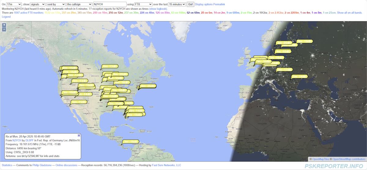
Here, I had plenty of spots, yet I struggled to get two in the log before I gave up and QSY’d to 15 meters. Changing frequency is as simple as pulling the jumper block out and moving the arrow to the correct frequency.

Thankfully, 15 was open and my first QSO was with a station in Ukraine and my second was in California.


I made contacts on 20, 17 and 15 meters. Could I manage something on 30? I tried but to no avail. I was spotted by stations on PSKreporter, but after calling for some time, I figured that midday in Connecticut was just not the best time for that band. Before I packed up for the day, I went back to 17 meters which was definitely better than earlier and I logged three more for a total of five on the band.

I took the opportunity to go back to Silver Sands a few days later to try the antenna on 12 and 10 meters, which I did not do on the first trip out. I also wanted to see how elevating the counterpoise might affect the performance. It was downright windy, so I brought along a camera tripod this time to provide more stability. Obviously, the extra weight carrying a full size tripod wouldn’t be ideal for a SOTA activation, but for my test, I brought it along.

The high band propagation was miserable when I went out, I was wondering if I’d be able to make any contacts at all. I was pleased to see that elevating the counterpoise allowed 17 meters to easily match to the antenna with a 1.0:1 SWR. I then tried 15, 12 and 10 meters which also tuned right up and I made contacts on all bands. 10 and 12 meters were open to my south. I made QSO’s with Belize, Mexico, Ecuador, the Dominican Republic and Puerto Rico.


The AX3 did not disappoint.
Making QSO’s from California to the Ukraine and down into South America while sitting at a picnic table in a park in Connecticut with just 10 watts using such a small antenna is simply amazing to me. I like the AX1, which I used primarily on 20 meters. Having the multi-band flexibility of the AX3 is very nice, especially now that the upper bands are active, and it provides more flexibility for operating portable and being able to change bands on the spot to adapt to the ever changing band conditions.