 As you might have noticed from past field reports, I’m a big fan of the LnR Precision Mountain Topper MTR-3B. It’s a wee CW-only transceiver that is almost perfectly designed for summit and park activating. It’s so lightweight and compact, you barely notice it in your backpack.
Thing is, the MTR-3B is no longer produced and I’m not sure if it ever will be again, but Steve Weber (KD1JB) hasn’t stopped making iterative improvements to the Mountain Topper design and LnR hasn’t stopped producing them.
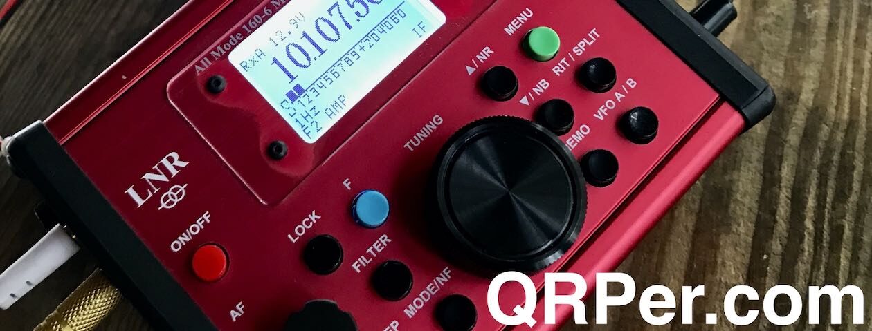
In late 2020, LnR introduced the new MTR-4B which replaced the MTR-3B and added a few extra features that many of us had been asking for including:
- Easy access to sidetone volume control (with a dielectric screwdriver)
- A built-in SWR meter
- A wider voltage range and higher output power (up to 5 watts)
- And the 80 meter band in addition to 40, 30, and 20 meters

The MTR-4B also has an attractive red gloss chassis.

And the right and left sides of the chassis even protrude a bit to better protect the front panel buttons and switches when the unit is flipped over on its face. Nice touch!
Generosity
 One of the great things about being me is I am often at the receiving end of incredibly generous people who like supporting what I do.
QRPer.com is a pure labor of love and I’d do what I do without any compensation, but it’s an honor when anyone goes out of their way to thank or support me.
Seriously: the kindness I feel here restores my faith in humanity.
In January, a reader (who wishes to remain anonymous) approached me with a deal I simply couldn’t refuse. He is a very seasoned and accomplished field operator but has only recently been upping his CW game. I believe as a reward to himself for starting CW activations later this year, he told me he wished to order a new MTR-4B.
What he proposed was to purchase the radio from LnR and have it drop-shipped to me. He wanted me to have the opportunity to review this little radio and log field time with it as well. He told me I could use it for months before shipping it to him and not to worry about it getting scratched or showing other signs of field use.
Wow.
I loved this idea because, as a reviewer, it isn’t financially viable to buy each and every radio I would like to review. I do like asking manufacturers for loaner radios, but LnR is a small manufacturer and make these units to order. I know them quite well and they simply don’t have extra loaner units lying around the shop–much like new automobiles these day, each one produced is already spoken for.
I accepted his offer with gratitude. I looked forward to getting my hands on the MTR-4B!
But that wasn’t all: this kind reader has actually been sending me coffee fund contributions that will add up to half the price of a new MTR-4B should I decide to purchase and add one to my own field radio arsenal! I tried, but I couldn’t talk him out of it.
So there you go. I’m so incredibly grateful.
Delivery
 As LnR Precision states on their website, there’s roughly a 6-8 week lead time on the MTR-4B. I took delivery of this unit in early March.

As with all LnR Precision products, it was packed amazingly well.


I wasn’t sure what to expect in terms of size, but the MTR-3B is only slightly bulkier than the MTR-3B (indeed, in my activation video below, I compare the two).
I love the hotrod red paint job!

This unit arrived during what turned out to be a crazy time for me–one where there was nearly a four week period with no field activations. That’s how crazy!
I did play with the MTR-4B in the shack, however, during that time and logged numerous POTA, WWFF, and SOTA activators. I even had a couple of 80 meter rag chews.
Many field ops were surprised that the MTR-4B didn’t use the forth band position for 17 or 15 meters and I tend to agree. In the field, efficient 80 meter antennas are a bit bulky for the likes of a summit activator. Then again, when in the shack or for extended camping trips? I find 80 meters a brilliant band for evening rag chews and late night DXing.
Not sure how much I’ll use 80M in the field, but I do appreciate this additional band!
Of course, the MTR-4B is built for playing radio outdoors and that’s exactly what I had in store for it on April 13, 2022. Continue reading My first POTA activation with the Mountain Topper MTR-4B V2 →
 Yesterday, Icom posted the following teaser and image above on Twitter in advance of the 2022 Hamvention:


