
by Teri (KO4WFP)
Monday, July 15, the second day of my North Carolina camping trip for POTA and SOTA, started chilly with overcast skies. Today I would attempt my first SOTA activations. I chose two easy summits – Black Balsam Knob and Richland Balsam.


Daisy and I headed out after a simple breakfast up US Highway 276 through the Pisgah National Forest toward the Blue Ridge Parkway. Along the route, we encountered Looking Glass waterfall. The last time I visited this waterfall, it was packed with spectators. Today, I shared it with only one other person. It was a nice way to begin what turned out to be a very long day (spoiler alert).


If you haven’t driven the Blue Ridge Parkway, put it on your bucket list! I’ve been on the parkway more times than I can remember. I relish driving it. Surprisingly, I encountered very little traffic this day so I could move at my own pace along the banked turns and stunning vistas.

The parking area for Black Balsam was already full when I arrived; however, several other cars were making use of the side of the road and I pulled in behind a couple who were suiting up for their hike. It turns out the husband of the couple had a father who was a ham and learned CW during World War II. It is a small world indeed.

The hike to Black Balsam Knob is not one I’d consider easy, especially scrambling over the rocky surfaces. Before the trip, I was concerned as to how Daisy would handle hiking given she’s done nothing like this before. It became obvious why she is a POTA pup – the terrain didn’t bother her in the least!

On the hike up, we saw Carolina lilies growing wild along the trail. There were also bees everywhere, especially in some yellow wildflowers I could not identify.


I was grateful the skies were overcast and the temps on the cooler side (upper 60s). There was a light breeze when we arrived at what I thought was the summit and the tall grasses stirred in it. You could see for miles! The hike was worth the view.

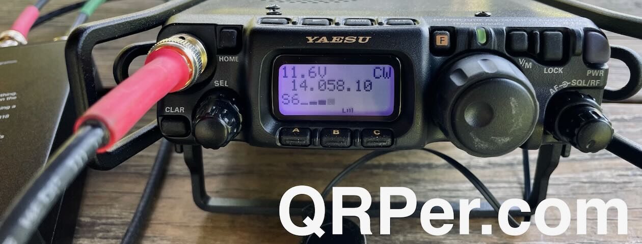
I originally thought I would use my EFRW mounted on a fishing pole for my SOTA activations. However, cleaning, stripping, and re-waterproofing the tent/rainfly took so much time, I didn’t follow through with a solution to support it on a summit with no woody vegetation. I opted to use the AX1 instead with the configuration Thomas has had the most success – mounted to the side of the KX2. I also took with me the counterpoises (20 and 40 meters) that came with the antenna.
Once on the air, I called CQ SOTA to make sure I worked those ops first given they are fewer in number than POTA hunters. Since the activation would count for both SOTA (Black Balsam Knob W4C/CM-003) and POTA (Pisgah National Forest US-4510), I gave my location (NC) for all exchanges. (I think SOTA just requires an RST.) I worked seven stations in ten minutes, a good rate.

I moved down one Hertz as I began faintly hearing someone else on the frequency. (Yes, I cleared it first; however, given I was operating QRP, fighting for the frequency was probably a losing battle.) It was at this point I began calling CQ POTA and the callers dried up. I did have cell service here and worked one park-to-park with Kenneth NS1C at US-11632 in Massachusetts. I continued to call CQ both on 20 and 17 meters with no luck. I didn’t opt to try 40 meters as I figured it wouldn’t be any better.

About the time I had packed up my gear, Gary W5GDW contacted me asking about 40 meters. I was loathe to pull my equipment back out. He also advised me there was a solar flare. (Maybe that was why I suddenly didn’t hear anyone.)
At this point, I had a valid SOTA activation but not for POTA. I figured the campground at which I was staying – Davidson River Campground – is in Pisgah National Forest so I could finish my activation at my campsite later in the afternoon.
As I headed down the mountain, I began questioning whether I had actually reached the summit. Something didn’t feel right. I checked the map at the trailhead and noticed Black Balsam Knob has a plaque honoring Art Loeb and I didn’t recall seeing any such thing. Uh oh. Maybe I hadn’t had my first SOTA activation. My heart sank.

First of all, it was demoralizing I had botched my very first SOTA. Second, how humiliating because of how public it would be. Honesty is one of my values and I’d have to admit the mistake. I almost scrapped the remainder of the day I was so bummed. However, I didn’t drive all the way to North Carolina to scrap activations so onward I went to the next one – Richland Balsam – which would give me a SOTA activation and two POTA parks. Did I redeem myself? Stay tuned…
Equipment Used
[Note: All Amazon, CW Morse, ABR, Chelegance, eBay, and Radioddity links are affiliate links that support QRPer.com at no cost to you.]
Another wonderful report, Teri!
I had hoped to join you on this SOTA outing, but my plans on the east coast of NC were extended, so I wasn’t in the area when you were.
SOTA certainly has a few extra challenges that POTA does not. I’ll mention a few here mainly for other POTA ops that want to explore the wonderful world of SOTA:
For one thing, if you’re not familiar with the trail, you’ll need to plan for the hike and all that it might present. Fortunately, SOTA activators post field notes for each summit that’s been activated–these notes have important information about the trail, options, what to look for, availability of mobile phone service, any notices or issues driving to the trailhead, how to find the trailhead, etc. etc. Here’s the one for Black Balsam, for example: https://sotl.as/summits/W4C/CM-005
I use more technology for my SOTA activations than I do for POTA. I have an iPhone loaded with the SOTA Goat app which simplifies scheduling and spotting myself in the field. It will also use the GPS in your phone to tell you how far you are from the true summit. Since SOTA requires that you are within 25 vertical meters of the true summit, this is something you want to carefully check on your first visit to a new summit. Not all summits are easy to identify without a GPS device. I also use GIA GPS on my phone which has excellent topographic maps and tracking.
I don’t think this is as necessary with a summit like Black Balsam where there are so many other hikers around and you’re never too far from your vehicle, but I’m also a big believer in a device like the Garmin InReach Mini if you hike alone in areas that are remote. This little device can not only track your hikes in real time and send your position via the Iridium satellite network. It’s also an invaluable resource for texting when there’s no cell phone service and calling for help in case you were to be injured during a hike. There’s a monthly service charge for it, though. Based on where you live (on the GA coast) I’m guessing SOTA is going to be done primarily on trips like this one, though, where you can choose the type of hike you want to do.
Anyway, I think I might turn this into a larger post for those who are dipping their toes in the world of SOTA.
Again, a great report and so glad you kept on keeping on!
Best,
Thomas
Thomas,
You hit many of the points I thought of making as I read Teri’s article. ne more comment on the Garmin inReach, you need to set things up ahead of time but the main SOTA site has instructions on who to contact so that you can even use it to spot yourself if you have no cell service.
Thomas,
Thanks for your comments.
I agree that Sotl.as is a great resource as I used it to pick which summits I would attempt on this trip. It is also where I found the photo of the ultralight tarp I purchased and take on these activations for shelter. However, despite my research before the trip, I think I still had a POTA-mindset going into this endeavor becuase that is primarily what I’ve done. SOTA is NOT POTA. That seems obvious; however, you can research and plan for something BUT until you’ve actually experienced it, you can’t know what it is truly like and where the “holes” in your knowledge are.
I considered a Garmin InReach Mini for the trip and ultimately nixed the idea because I thought to myself I won’t be activating SOTA often and I purposely picked easy summits on which I’d be likely to encounter people. But I am reconsidering using the device because the wildlife management areas to which I travel in Georgia are remote and, as I have discovered, often don’t have great cell coverage. For safety sake, this device is probably a worthwhile expense for me. It will also come in handy for future SOTA activations.
These SOTA activations, though a challenge for a noob like myself, wet my appetite for more. I love a good challenge and am already plotting when I can get away from the coast next year and put a few more SOTA under my belt.
72,
The POTA Babe
Teri KO4WFP