
My wife and kids were with her parents for some days, the weather forecast 25° C / 77° F and the following Monday was a public holiday in Germany – perfect condition for an activation day trip during the weekend. With France and the Czech Republic already visited this year, there were two other neighbor countries waiting to be visited: Switzerland and Austria (the one without kangaroos). Austria is on my schedule for the Ham Radio fair in Friedrichshafen, so it became Switzerland.
The area northwest of the Swiss town Schaffhausen was perfect.
The region has been inhabited for more than 10,000 years. Schaffhausen started as an independent city-state around 1000 AD and became a Canton later. A canton is a type of administrative division similar to a state, but in European dimensions. The Swiss Confederation, as a whole, is smaller in size compared to West Virginia and has a slightly smaller population than New Jersey. Anyways, in 1330, the town lost all its lands and its independence, but regained its independence back in 1418. Schaffhausen joined the Swiss Confederation as the twelfth member in 1501. In 1944, Schaffhausen experienced a bombing raid by aircrafts from the US Air Forces, which misidentified the town in the neutral Switzerland as their target Ludwigshafen in Nazi-Germany.
The region is not too far from my home, it has a SOTA summit, which is in a POTA and WWFF area, is history-rich and has a second, although German, SOTA summit not too far away.

I started early on that Sunday morning at 8 a.m. The autobahn was nearly empty and just like an invitation to drive a bit faster. Since Corona, I haven’t been using my car very often, so I still had winter tires on, which are limited to 160 kmh / 100 mph.
Since 2008, Switzerland is in the European Schengen Area, so there are no regular border checks. Even before, it was a so-called “Green Border”, i.e. you could often pass it without checks. Without this old, unused border station, you would barely notice that you have crossed the line.

Some minutes later I approached the area, where the first summit is located.

The Wannenberg / Wannebärg (HB/SH-002) is a wooded mountain with an elevation of 661 m / 2168 ft. The peak is rather flat and also wooded. The way from the parking place at the foot of the mountain to the top is rather short and easy, with 2.1 km / 1.3 mi and an ascent of 140 m / 460 ft.

You can activate HB-0040 Schaffhausen Regional Nature Park for POTA and HBFF-0346 for the World Wide Flora & Fauna program while being on the SOTA summit.
There is a kind of logging place, which came in very handy. It was Sunday and a Christian holiday, so there was no risk of being disturbed by anyone. In Switzerland, with a few exceptions, Sunday work is prohibited.

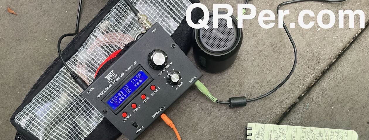
Since I wanted to operate on the 40-meter band, I was glad to see that the forest wasn’t very dense around that place, and I raised my 10-80-meter band end-fed half-wave antenna.

My equipment consisted basically of my new Icom IC-705, a mAT-705 antenna tuner (not used here), 4Ah LiFePo2, 10 meter / 33 ft fiberglass mast (not used there), a bunch of end-fed half-wave antennas and a BaMaKeY TP-III twin paddle.

The camera tripod with flexible legs is something I can recommend. It improves the stability of the IC-705 but also elevates the transceiver slightly and makes the viewing angle adjustable, which makes it more comfortable to look at it and work with.
I started with SSB on the 40-meter band. It worked very well and after a half hour and 32 QSOs I switched to CW, where I made an additional 22 QSOs in another half hour.

So I set out to visit the remains of a Roman farmstead that I wanted to see on my way to the other SOTA summit. According to the public office of archaeology, the western front wall of the main building, situated on an elevated spot, should still be visible. The farmstead was operational in the 2nd and early 3rd century AD and was subsequently abandoned. However, I could not find it, just a nice Inn and Winery at the place where the ruins were supposed to be.

So I went further to my next station: The Ruins of Radegg.
In the meanwhile, it became a bit hot and the difficult trail with the steep ascent made it a harder to reach the castle.

Looks a bit like Indiana Jones on the next photo, doesn’t it?

The Ruins of Radegg were studied between 1923 and 1937, but little is known about their origin and destruction, as well as the Barons von Radegg who built the castle. There were two families with the name von Radegg in the 13th century, which makes it challenging to attribute individuals to the ruins. The castle walls visible today were likely constructed after 1200, and there might have been a previous wooden structure on the site. The castle was probably destroyed around 1300, possibly due to conflicts between the von Radegg family and the neighboring von Krenkingen family. Excavations revealed signs of fire and the discovery of arrowheads and crossbow bolts.
In the Wikipedia article for the Ruins of Radegg, you can find The Legend of Kätterli with another story about the destruction of the castle.

I find it fascinating that these structures are still visible 700 years later.

On the way back, I took a longer but less steep trail.
I went on to the last point on my list – the SOTA summit Napberg (DM/BW-461). The 641 m / 2103 tall Napberg is in Germany but so close to the border (dark green line), that the activation zone extends to Switzerland.

The peak is like a high plateau, so from the parking place at a farming hamlet and stud for tourists, it is a light walk to the actual summit.

I wanted to make it a bit more interesting and continued to the Swiss part of the activation zone. Using a callsign from the UK with a Swiss HB9 prefix to activate a German (DM/) summit made it a fun combination.
I was already a bit tired and had my required QSOs for a successful POTA and WWFF in my log. Therefore, I just wanted at least 4 QSOs for this SOTA summit. I raised a single-band end-fed half-wave antenna for the 20-meter band on my fiberglass mast. Since I wouldn’t have been able to explain the combination of a UK callsign, Swiss prefix, and German summit in CW to anyone, I operated in SSB only.

I tied my mast to the boundary stone of the international Swiss/German border, which opens the question, which call sign I am supposed to use. As the mast tended a bit to the Swiss side, I decided for my UK callsign with HB9 prefix i.e. HB9/M0KEU/P- otherwise I had to use my German callsign i.e. DM1TBE/P – the suffix is optional but widely used in Europe as opposed to the US, where I have not seen a lot of POTA spots with a /P.

The boundary stone was set 1839 and labeled with:
CS – Canton Schaffhausen
W – Gemeinde (municipality) Wilchingen
on the Swiss side and
GB – Grossherzogtum (Grand Duchy) Baden
A – Gemeinde (municipality) Albführen
on the German side
The Grand Duchy of Baden was a 1806 founded sovereign country and became a partially autonomous federal state within the German Empire in 1871.
Germany, as a joint country, was founded very late when compared with other nations. Until 1871, Germany consisted of independent kingdoms, grand duchies, duchies and princedoms and the Grand Duchy of Baden was one of its foundation members.
I spotted myself and after 15 minutes I had 10 QSOs in my log, much more than needed. Since I operated in Switzerland, those QSOs also counted for the POTA and WWFF activation.

Feeling fortunate, content, but also quite exhausted, I began my journey back home – on the photo below from my home QTH view a view my beloved Swabian Alb.

Another excellent field report, Thomas! I love how you were able to do your activation while straddling that line between Switzerland and Germany.
I love all of the history you include in your fine reports.
Cheers,
Thomas
K4SWL
Welcome to my Country, I hope you enjoyed it. 73 qro HB9GUR
Hi Philippe,
yes, I enjoyed it a lot. Your country has so much to offer, history- and ham-radio-activation-wise. I will come back.
Cheers
Thomas
Well interesting to say the least. I wish you would have had a video to go along with your travels. Setting up antennas and communication audio. Wonderful presentation. Thanks for your wonderful presentation. AC5VB
Thank you, John, happy you like it. Regarding the video, I’m afraid that my accent is so strong that I wouldn’t even understand myself in a video. 😉
Gosh LOL thank you for your honesty and humor my friend. You are the very best indeed! LOL I love love love the presentations by the contributors. Keep them coming please!
Thomas B,
Your history reports are a fabulous addition to your activation reports. Please keep them coming.
I could find only one very tiny flaw … You failed to mention that the international country code for Switzerland is CH, which stands for CHocolate. 🙂
Thanks!
Bob, N4REE
Thank you, Bob, for your kind feedback.