 Besides Lane Pinnacle, there’s been one SOTA summit, in particular, I was eager to activate this year: Bakers Mountain (W4C/WP-007).
I practically grew up in the shadow of this little outlier mountain in Catawba County, North Carolina–my home was only a couple miles away as the crow flies and it has always been a bit of a landmark in my childhood stomping grounds.
Growing up, the land in/around Bakers Mountain was basically off-limits and privately owned. In the late 1980s, one of the land owners gave a large tract of land to the county to protect it from development (which started booming in the area around that time).
In June, 2002, while I was living in the UK, Catawba County open up the 189 acre park and its 6 miles of trails to the public.
I love Bakers Mountain park. Even though the mountain isn’t terribly tall (1780 feet/543 meters ASL) parts of the trail system are fairly strenuous. When I want to escape and clear my head, the Bakers Mountain trails are the perfect medicine.
Bakers Mountain: What’s in a name?
 An interesting tidbit about Bakers Mountain that I learned from one of the park rangers: it was originally called “McBride Mountain“ in the late 1700s, but as more German settlers moved into the area, German family names became predominant.
The Baker family had large tracts of land in/around the mountain and, locally, people started referring to it as “Baker’s Mountain” sometime in the 1800s and the name stuck.
Officially, the name of the mountain is “Bakers Mountain” although, I suppose, it should have been called “Baker’s Mountain” or maybe “Bakers’ Mountain.” An apostrophe was never added, though.
It’s a source of confusion for those who make maps and refer to the mountain. In the SOTA database, it’s referred to as “Baker Mountain.” That is incorrect, of course, but the SOTA database is likely built upon one of the topographic map databases where it’s incorrectly labeled.

So there you go. Tuck away this bit of trivia and sound like a local next time you’re in Catawba County!
Now where was I? Oh yes…
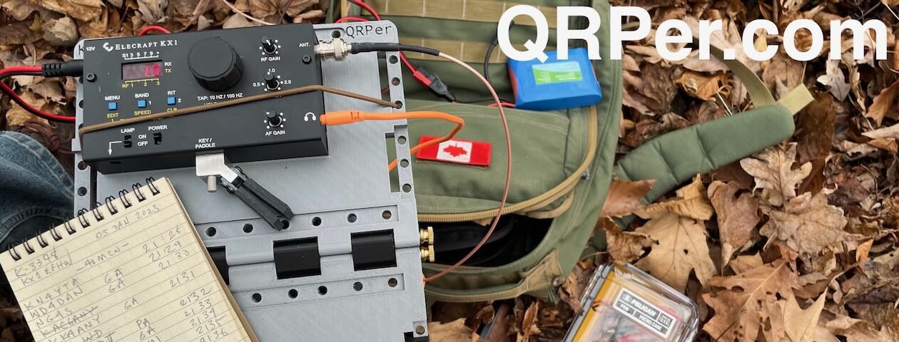
 So on Wednesday, May 19, 2021, I packed my Elecraft KX2 and PackTenna 9:1 UNUN antenna in the GoRuck GR1, and hit the Bakers Mountain trail system.
The weather was perfect, although the humidity was incredibly thick that day.

Mountain Laurels were in bloom and flanked portions of the trail.

I took the main red-blazed loop trail.

The trail is very well-marked and maintained with maps posted throughout.

At one point, you’ll happen upon the old home site.
The trail has a few steep sections, but overall is pretty moderate.

There’s no missing the summit trail.

Following the orange mountain top trail will take you to a gazebo and observation deck near the summit.


Keep in mind, though, that this is not the true summit of Bakers Mountain and isn’t close to the 25M SOTA activation zone. Still, the views are fantastic here, so take a breather and soak up the Catawba valley.

Click the pano image below to enlarge in a new window.

To find the trail to the real summit, you must follow the path crossing under the power lines near the observation area–you can’t miss it. While the public isn’t encouraged to take this path–and it is not a part of the Bakers Mountain trail network–a park ranger told me that the current owners don’t mind the odd SOTA activator following the trail to the summit.

The path–since it’s not a part of the public trail–is a bit overgrown. Follow this path until you intersect an overgrown narrow access road. At the intersection take a left and this will lead you to the true summit. The ring road around the summit is well within the AZ.

I found a little spot to set up among the trees on the summit. No views, but it was the perfect space to deploy the PackTenna 9:1 UNUN!
Gear:
- Elecraft KX2
- Packtenna 9:1 UNUN Random Wire Antenna
- GoRuck GR1 USA
- Weaver arborist throw line/weight and storage bag (affiliate links)
- Tom Bihn Large Travel Tray
- Rite In The Rain Weatherproof Cover/Pouch (affiliate link)
- Jovitec 2.0 mm Mechanical Pencil (affiliate link)
- Muji A6 Notepad (affiliate link)
On The Air
This being my first time activating Bakers Mountain, of course I made a real-time, real-life, no-edit video (see link below). Sorting out a way to set up the camera position took me longer than deploying the antenna and unpacking the radio! It can be a real challenge on a stony mountain summit.
The KX2 paired beautifully with the PackTenna 9:1 UNUN. I got a great match on 20 meters.

I started calling “CQ SOTA” and spotted myself on the SOTA network using the SOTA Goat app.
My first contact was SA4BLM in Sweden–I almost fell off of my rock!
Next, I worked KR7RK in Arizona, AE0XI in South Dakota, and HA9RE in Hungary! All in eight minutes.
Wow!
Next, I moved up to the 17 meter band where I logged AC1Z in New Hampshire, F4WBN in France, and KT5X in New Mexico.
Finally, I moved down to 40 meters where I worked K3TCU in Pennsylvania, K8RAT in Ohio, W4KRN in Virginia, and K4MF in Florida.
My total activation time was about 25 minutes.
QSO Map
Here’s the QSO Map plotting out my QRP contacts. I must say, that modest PackTenna did a lot with my 5 watts! That and some good Bakers Mountain mojo! 

Video
Here’s my real-time, real-life, unedited video of the entire activation from start to finish:
Click here to view on YouTube.
That was fun!
When I hike at Bakers Mountain, I add spur trails and connectors to make it as long as can in the time frame I have. The trip back to the car was actually a longer hike than it was to the summit.
But I had a spring in my step.
I was absolutely chuffed that my first activation of this particular summit was so exciting and fun. It still blows my mind what can be accomplished with 5 watts and a modest wire. I can’t wait to go back again.
Do you enjoy QRPer?
Please consider supporting us via Patreon or our Coffee Fund!
Your support makes articles like this one possible. Thank you!

I love your blogs, keep it up! You illustrate with awesome scenic shots of your surroundings. Thanks for motivating me to get out there and do field radio.
73
de AI5DD
The pleasure is all mine, Joe. Thank you so much for the kind comments!
73,
Thomas
K4SWL
Thomas:
On the pic of the elevation map there’s indication of a radio tower. Any idea or info about that?
You know, I’m not certain what’s on that tower. I know it’s been owned by the same company for decades, though. Some also mistake that point as the summit, but it’s not even in the activation zone–which is a good thing because it gives you a bit more distance from that RF.
Enjoyed the video as well.. grew up here and still live in Catawba County. Your videos and blogs are inspiring an new old ham to POTA and SOTA. Thanks and take care
Enjoyed the blog post and the video. That’s an impressive list of contacts!
Robin, NG8S