
Radio Adventures on the Outer Banks of North Carolina
by Bob K4RLC & Alanna K4AAC
February 2025
My YL Alanna K4AAC had been advocating for a trip to the Outer Banks of North Carolina for some time. She had never been there to see its incredible natural beauty, and I had not been in decades. In planning, we needed to go in the off-season, especially when it was a bit chilly, as she is a “bug magnet” and that can ruin her vacation. Not being totally unselfish, I wanted our visit to coincide with a radio event.
We first tried for Winter Field Day at the end of January, but Eastern North Carolina was socked in with five to seven inches of snow in places where it never snows. We rescheduled the trip for a month later at the end of February, to coincide with the North Carolina QSO Party. Just so happens, Eastern North Carolina got another freak snowstorm of several inches, but we only had to put the trip off one day. Even then, parts of the roads going down east were still covered in snow and ice.


The drive is only a bit over 3 hours straight down US Highway 64 to the Outer Banks, where it dead ends in a T intersection with infamous North Carolina Hwy 12. Locals call the intersection “Whalebone Junction.” Going either north or south of this intersection, within a few miles one can explore lots of really beautiful natural areas, including six (6) POTA sites! Eight miles south of the intersection is the Oregon Inlet Campground on Bodie Island, part of the Cape Hatteras National Seashore (US-0682), where we camped. That time of year, the campground was really deserted with only a few other campers including a few brave souls tent camping. It is a flat area campground that backs up to huge dunes, separating you from some of the most beautiful but austere beaches on the Atlantic coast. A word of caution though, there are no trees or light poles to secure a mast for an antenna.


We took our Winnebago Solis again. The Solis is a wonderful camper van on a Dodge ProMaster chassis that sleeps three, has a propane powered furnace and two burner stove, and a refrigerator that can be powered either by propane or by the 140 W solar panels on top of the van, loading up two 100 amp hour AGM batteries. You can boondock for days, or enjoy the luxury of “shore power.”
As the North Carolina QSO Party was Sunday, we wanted to explore the islands Saturday. About 20 miles north of the campground is the incredible Wright Brothers National Memorial, commemorating the first flight ever, and also POTA site: US-0797. This is part of the National Park Service, on 428 acres with an interactive Visitor Center whose exhibits include a full-scale reproduction of the Wright Brothers 1903 flyer. We particularly enjoyed climbing to the Wright Brothers Monument standing 60-feet tall atop Kill Devil’s Hill, a 90 foot high grass-stabilized sand dune. The original runway is there with First Flight Boulder and Markers charting the short distances of the first four flights. Incredibly, a few yards over and parallel is an actual 3000 foot First Flight Airstrip where pilots from all over the world fly in to celebrate their flying heritage. I decided to take the KH1 up to the top of the Monument, a steep but accessible walk for almost anyone. The day was clear and sunny; the white granite monument was gleaming against the Carolina blue sky.


It was a beautiful day to set up on the wall around the monument. Unfortunately, the temperatures were in the 40’s, and I didn’t realize there would be a 20-25 knot wind blowing. The beautiful thing about the KH1 is that it is so easy to deploy. Some have complained about the stock key in cold weather, but for me the problems are not the key but old, cold fingers. To help a little bit, I set up the AX1 on a small camera tripod and threw one 13 ft radial over the wall into the field. This modification worked really well when I operated at a Greek Navy lighthouse in the Aegean Sea. For some reason, the KH1 was fussy that day, and would not hold a tune consistently on 20 CW. Nevertheless, I pounded away until I got the minimum number of contacts about the same time my fingers just wouldn’t work anymore.
Alanna, with freezing extremities after fully exploring the monument and taking pictures of me operating, hiked off to explore a bronze sculpture garden which recreates the scene of the historic 1903 flight. This included a sandy plot with a life-size bronze replica of the original Wright Brothers airplane (being piloted by Orville laying on his stomach), along with bronze sculptures depicting the guys from the Hatteras Life Saving Station who were there to support Orville and Wilbur, help them launch their flyer, and capture a photo of the First Flight. The memorial was gifted by the State of North Carolina to the NPS, and dedicated at the Centennial of the First Flight in 2003, by then Governor Mike Easley. Alanna and I were both really cold and tired after hiking in the chilly weather at the park, so we sought out one of the few open seafood restaurants there and were treated to an incredibly tasty buffet.


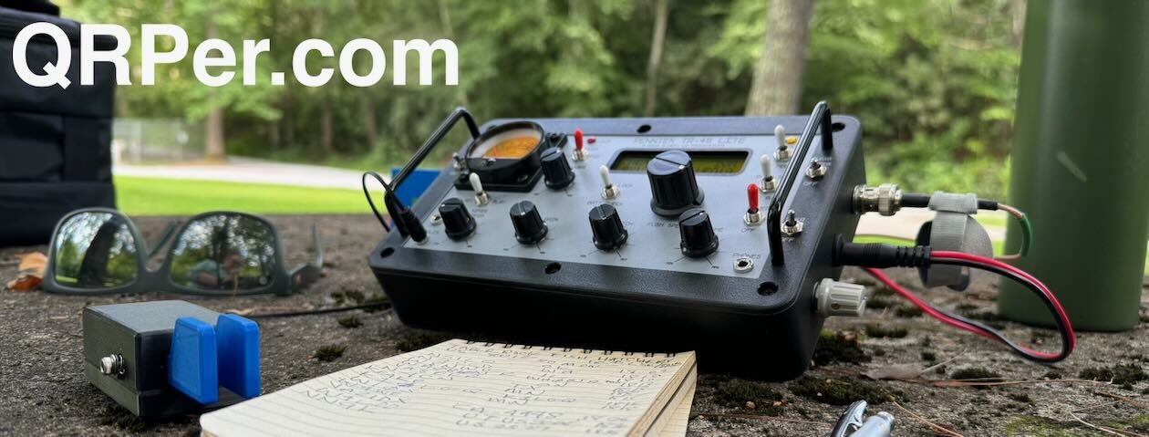
Weather Sunday morning was milder so with a strong cup of coffee from the French press coffee maker our daughter gave us, I set up on the picnic table with my trusty old ICOM IC – 706MkIIG at about 60 watts on 20 CW. I do have a trailer hitch mount for the Solis that can hold a 30 foot fiberglass mast, but I knew we were going to be traveling that day. So I set up my trustee default of a 17 foot whip on a 4 x 7′ piece of aluminum screen wire from Lowe’s. With one CQ, the calls started coming in, with the first one being from HA9RE in Hungary.
I had posted that I would be activating Dare County for the QSO Party and think I was the only station activating the somewhat rare County. A pileup ensued – I did the best I could as I swear four stations were identically on top of each other at the same time. After the first long run of stations, we had a modest breakfast of yogurt and homemade banana bread, still stuffed from the seafood buffet the night before.


We drove up to Jockeys Ridge State Park (US-2737) barely a mile below the Wright Brothers Memorial. Jockeys Ridge is one of the geological wonders of the world and home of the largest sand dunes on the East Coast of America. When I took Geology courses at UNC-Chapel Hill, one Prof said you can see geology in action at the beach almost instantaneously, where, in other places, it takes millions of years for change to happen, such as the Appalachian Mountains in the western part of our state.
The sand dunes at Jockey’s Ridge were formed by wind action blowing billions of individual grains of sand from the beaches into a landscape that looks like something in the Sahara desert. When you stand on top of the largest dune, about 100 feet high, you can see the Atlantic Ocean to the east and Roanoke Sound to the west. This is a fun place for hang gliders and for the little girl who brought her plastic sled to sled down the sand dunes like she was in snow. The other interesting thing is that Jockeys Ridge is the eastern terminus of the North Carolina Mountains-to-the-Sea Trail (US-8313), which begins in far Western North Carolina in the Great Smokey Mountains National Park, and meanders 1175 miles from east to west. We’ve section hiked parts of the trail in the Western North Carolina mountains, and where it runs through the northern part of Wake County where we live. As it continued to be cold, windy and sandy in the sand dunes, I decided not to set use the KH1 there but went back to the nearly deserted parking lot to a picnic table and set up the IC 706 again.


Again there was a pile up with Europeans such as Germans and French who wanted to work Dare County, as well as others who wanted to work this desired POTA site. After an hour or so, an old Jeep pulled up and a guy got out, looking as classic U.S. Navy as possible with a beard and regulation Watch Cap. I noticed that the license plate on the front of his Jeep said “Retired Cryptographers Association  ” This was George KF4UCC, who lives north of the park on an island in the Albemarle sound, and was a Navy cryptographer. He said he liked to come to the park and meet other hams he had worked. We had a great time talking about Navy experiences, radio, and living on the Outer Banks. It was a real privilege to have an eyeball QSO with George.


George volunteered to drive to a little known POTA site on the way back to his island, so we could have a simplex HT voice QSO. This is the Nags Head Woods Ecological State Preserve US-3862. This land is privately owned by the Nature Conservancy and is one of the largest remaining maritime forests on the East Coast.
On the way back to the Oregon Inlet campground, we stopped at the Bodie Island Light Station. This is the third Bodie Island Lighthouse, built in 1872 when that section of the banks was still its own island. During the summer, you can climb it’s 219 steps, but not that day. Still, it is so beautiful. While not a separate POTA site from Cape Hatteras National Seashore, it is listed in the Amateur Radio Light House Society program as USA-067. I pulled out the KH1 just for grins and quickly starting making contacts while walking around the lighthouse. I think the 170 foot lighthouse gave the antenna a boost!


Our stay at the campground was up Monday morning, but I wanted to make one more stop on the way back to Raleigh. West of Nags Head, across the Roanoke Sound, is Roanoke Island, the home of the famous “Lost Colony” from 1587, as well as the home of the “lost” radio station of Reginald Fessenden, set up in 1902. I had been able to exchange emails with John NC4AT, a retired National Park Ranger who lives on Hatteras Island at the southern part of the Outer Banks and is a member of the Outer Banks and Fessenden Radio Society.
Last year, Alanna and I visited Marconi’s original sites on Cape Breton Island Nova Scotia and activated his memorial station near Glace Bay (CA-4842) as well as Marconi’s house, (CA-5830) built in 1905. The U.S. Navy and the National Weather Service saw the value in wireless radio communications, especially in a wild place like the Outer Banks, one of the most hurricane-prone parts of the country and well known as the “Graveyard of the Atlantic” due to the hundreds of shipwrecks off the nearby coast. But, the NWS and USN did not want to work with Marconi. Instead, they contracted with Fessenden to move his radio lab from Cobb Island, MD, and set up a station on the north/northwest part of Roanoke Island. Fessenden actually had a background in electronics (which Marconi did not) and was able to develop a better receiver than Marconi’s coherer tube, a device called a “barrater”. Fessenden also transmitted the first voice transmission over wireless telephony around 1900, but no one was really interested at the time in what would become Amplitude Modulation!
When we went to the Fort Raleigh National Historic Site, we met Ted- a retired Park Ranger, now Park Service volunteer- who said I was the second person who asked about Fessenden. Unfortunately, according to him and John, the site of the original transmitter station is now underwater. Also according to John, Fessenden had another site on Hatteras Island. Interestingly, Marconi also had a site on Hatteras Island near the fishing village of Buxton, but no one knows exactly where it was.
We had a delightful morning not only discussing the lost radio station but more importantly the Lost Colony, the site of the first English settlement in America in 1587. Please read the history of this Lost Colony and how when the founder, Governor John White returned from a supply mission to England, the village was totally gone- with no sign of the 117 colonists he had left behind 3 years prior. The colonist group famously included both his daughter and baby granddaughter, Virginia Dare, the first English child born, and baptized, in the New World. All that was left behind was a carving into a nearby post with the word “CROATOAN” and the letters “CRO” carved into a tree. Archaeologists are still debating the mystery of where any surviving Roanoke Island colonists went next, but many think the carvings referred to Hatteras Island, whose native American name was Croatoan. The settlers certainly could have benefited from wireless telegraphy!
Of course, Fort Raleigh is also a POTA site (US-0820) so I sat up on a picnic table in the parking lot, eating one of Alanna’s delicious turkey and Swiss cheese on Rye sandwiches and working 20 CW. It was a delight to give POTA hunters such rare sites as Fort Raleigh, the Wright Brothers Memorial at Kitty Hawk, Jockeys Ridge, Mountain-to-Sea Trail, Bodie Island Lighthouse, and the islands of the Cape Hatteras National Seashore.


A word about geology: the Outer Banks are incredibly beautiful but formed by geologic action due to ocean sand, waves, wind, and current that is on-going. When the 1587 settlers came, there was a large opening between Nags Head and Bodie Island (see the White map from 1585 above) such that they sailed through the Outer Banks, and straight onto Roanoke Island, with the hopes of starting farms and raising crops. Also, there is debate about whether the Outer Banks are barrier islands or sandbars. Technically, they are both.
They were formed around 120,000 years ago when the Atlantic ocean covered coastal North and South Carolina, up to of distance now at Interstate 95. The waters receded and eroded the land, leaving sand bars now called the Outer Banks. While they are barrier islands that protect the coast, they are sandbars and shift constantly. There is concern about losing them due to the natural ebb and flow of oceans (ocean over wash of land, including Highway 12, from hurricanes) and natural migration of island sand, as well as the dreaded rises in the sea level. In fact, two of the National Park campgrounds near Hatteras Island are open only limited times of the year due to coastal flooding. Man-made interventions may have actually made the situation worse. For radio, we benefitted from lack of obstructions to take off angles on the flat islands, dune elevations at Kill Devil Hill and Jockey’s Ridge, and the nice effects of a “salt water amplifier.”

 Overall it was a delight to be there and see the beautiful nature that our state has on the Eastern end, parallel to the beautiful Appalachian Mountains on our Western end. If you go further south on Highway 12 to Hatteras Island, there are other POTA sites. As Highway 12 ends at Hatteras Island, you would need to take an almost 3 hour ferry back to the mainland through the beautiful Pamlico Sound. That’s our plan for the next trip. For now, we are still enjoying memories and photos of our recent radio trip to a beautiful coast with an incredible history of our country, as well as incredible simultaneous radio history with Marconi and Fessenden and the Wright Brothers. Hope you can all make it there sometime.
Thanks to the current and retired Rangers and volunteers at the National Park Service sites – treasured gems that need to be preserved
Radios:
- Elecraft KH-1
- ICOM IC-706MkIIG with Putikeeg CW Paddle (Amazon)
Antennas:
- Elecraft AX-1 on small camera tripod
- Hybrid vertical made of 17ft Chameleon Whip into a Wolf River Coil tripod, resting on a 4X7’ piece of aluminum screen wire from Lowe’s
Accessories:
- Battery for IC-706: Bioenno 20 AmpH LiFePO4 in PowerWerx PWRbox2
Logging:
- Mini Legal Pad from Office Depot and assorted pens and pencils
REFERENCES:
How to Read a North Carolina Beach. (2004). Pilkey, O.H., Rice, T. M., & Neal, W. J. University of North Carolina Press.
Exploring the Geology of the Carolinas. (2007). Stewart, K. G., & Roberson, M-R. University of North Carolina Press.
Signor Marconi’s Magic Box. (2003). Weightman, G. Harper Collins Publishers.
National Park Service brochures and Park staff.
Thanks, Bob & Alanna!
Great report, and great pics! I hope to put some of the information to good use, as Becky and I are leaving for our annual pilgrimage to OBX in two days. I will have to try for the MST / Jockey’s Ridge SP 2-fer. I think my favorite OBX Activation was at Pea Island NWR (I got the T-shirt…).
Best 73 de Brian – K3ES
Brian – It’s wonderful Becky & you make OBX annually! WX report for the week there looks great. John NC4AT – retired NPS Ranger – lives in Rodanthe and would be happy to meet you. He’s on the OBX Repeater system. Next time, we plan on making a loop, taking Highway 12 all the way south to Ocracoke Island, then taking the Ferry back to Swan Quarter.
Hope yall have a great time.
73 de K4RLC Bib
Bob, That’s a great unobtrusive and non-damaging setup for activating parks like the Wright Memorial. Good example for other activators.
Steve – Tnx for the very nice compliment. Way back, I did wilderness backpacking and tried to follow the “Leave No Trace” ethic in the back country. It would have been really interesting to have a KH1 in 1974 when we got “lost” for a few days in the Selway-Bitterroot Wilderness in Idaho
73 de K4RLC Bob
Bob:
Wow! You share so much information in your report. Thank you for the historical and modern day lessons. Visiting and activating the Outer Banks is a dream of mine. Your report will come in handy when I finally bring that dream to reality.
I’m glad you and Alanna had a wonderful trip. I look forward to the next report you share with us.
72,
Teri KO4WFP
The POTA Babe
Hey Teri – glad you enjoyed our report. We like to activate places with history and natural beauty. The Outer Banks certainly meets those criteria. When you do visit, you could take the NC Ferry from Swan Quarter, not far from I-95. The ferry is a really neat almost 3 hour ride across the Pamlico Sound to Ocracoke Island. From there, you can go north on Highway 12. This part is really natural seashore. North part of Highway 12 starts at Whalebone Junction, intersection of Hgwy 64. It’s pretty commercial, but just a few miles north are the Wright Bros Memorial & Jockey’s Ridge SP……Our next big historical outing is to the Charleston, South Carolina area and Ft. Sumter and surroundings. Not scheduled yet, but off-season is better time for that. Hope you have some great POTA outings, too.
Hello Bob & Alanna. Thanks for sharing your great POTA / LOTA trip with us. As I have married my wife on top of Wangerooge Lighthouse I especially like the “Bob in front of lighthouse hamming” picture.
Keep on POTAing! Cheers from Germany, Chris, DL7CW
Chris – that’s really a cool place to be married.