
My goal for this summer is to do more backpacked day-trip POTA activations while I’m still physically able to. This is my 4th backpacked-in activation this past week or so. And a thank you to Thomas K4SWL for letting me share my adventures from the Canadian out-back.
Today’s goal is to activate Trout Creek Ecological Reserve, CA-4221 which is about one-hour drive south of Kelowna, BC, Canada, which is where my wife Alexis (VE7LXE) and I (VE7EFF) have lived for the past 12 years. Alexis accompanies me on all my POTA activations.
It is a beautiful late August day. The temperature is expected to be about 31℃, or 88℉. The one-hour drive is just the beginning of the day’s adventure. We were able to conveniently park at the Summerland Golf and Country Club, but this is where all conveniences end for us.
Trout Creek Ecological Reserve has never been activated before – I’ll be the first. It’s no surprise this reserve hasn’t been activated before. It’s all wilderness with no trails to follow. I have to rely on my Garmin 66sr GPS and Pixel8 smart phone with Google Maps with Satellite View to help me navigate to and through the reserve in search for an optimal operating location.
I expected the trek to only be about 1 Km in with about 600 ft elevation gain. It’s all uphill, all the way. From the golf course parking lot, the hike starts out relatively easy. At first, there appears to be some semblance of a trail.

This old dirt road/trail didn’t lead to anywhere we were going. In short order we were strictly relying on my trusty GPS for directions to the reserve boundaries and ultimately somewhere to operate.
Alexis (VE7LXE) accompanies me on all our treks. She got her ham license so we can stay in contact via our trusty IC-V80 handhelds for safety reasons while in outback situations, should the need arise.

I was surprised at how quickly the terrain became quite steep. As you can see, there are no trails to follow. We are direction finding strictly by GPS and visuals.

This is the only gated entry into the reserve. The gate is not marked on any maps that I can find. And, as you can see, there are no trails leading into or out of the area. If we do come across any trails, they are usually game trails made by deer, elk, or bear.

This ecological reserve is a combination of mountains, grasslands and forests. Today we are wearing gaiters over our socks and boots to protect our ankles because these grasses in BC are seeding, and the seeds are like little spear heads that embed into our socks and boots. We just bought these gaiters because of lessons learned from our previous hikes in grasslands areas.
I understand that this eco reserve is also home to gopher snakes and even rattlesnakes. And of course bears are a given. Typically, when out back we carry bear spray. But today when we were putting on our trekking gear, I thought because we are so close to civilization at the start (golf course), I thought that perhaps we don’t need the extra weight and bulk of bear spray. I later realized that may not have been the wisest decision.


Cactus and rattlesnakes in Canada! What makes these little cacti so dangerous is how they are often hidden in with the clumps of grass. If you sit or fall down on one of these, you won’t be very happy – as I found out later. The higher we trek, the more scenic the views.
While it was possible to find an ops spot shortly after entering the reserve, we are surrounded by mountains. I was skeptical about viable radio propagation at the lower elevations. So as always, I seek the highest elevation I can realistically access. Higher elevation and a view of the horizon is always good for propagation.

After a while, we are starting to reach a viable elevation. The view behind Alexis is facing southeast, the optimal direction I try to orient my antennas for best USA coverage from southern British Columbia.

Today, the skies are a crystal clear blue and the scenic views are stunning. This is what makes it worth all the hard work getting here. However, we still have some slogging to do, yet. While it’s not obvious in the photos, this mountainside is turning into a slippery scree slope.

The views get better and better with elevation. But Alexis is starting to struggle with the steep uphill climb. However, I can see a viable mini-summit (or whatever it’s called) that once reached will hopefully make the trek worthwhile.
Very steep, lots of grassy scree, and some rock cliffs ahead. I’m hoping I can find a viable route to get up to this mini-summit and hoping for a viable POTA operating spot once we get up there (fingers crossed).
At this point, it’s starting to feel like we are mountaineering.

I admit, this is starting to feel like I’m pushing our limits. My wife isn’t too happy with me right about now. She is starting to get exhausted. And I’m getting tired myself. For many of the young folks out there, this is probably not much more than a walk in the park, so to speak. But we are now 73 and 72 years young and not exactly in top physical condition. All that said, I love these kinds of outdoor challenges as years back, I was an avid hiker in the Rocky Mountains of Alberta.
To be frank, this scramble up is getting to be a bit on the dangerous side. The rocky slope is unstable and slippery. But we are almost to the top and hopeful we will find POTA heaven up here….

No sooner than we reached this mini-summit crest, I see that we could have uninvited visitors.While bears are in abundance in the mountains, there is nothing like a pile of bear scat to confirm their presence as a reminder. (Uh-oh, we left our bear spray in the car)

Yeah, we finally made it up this mini-summit (there are higher ones above here), but this looks like we are close to where I think will be a suitable area for POTA ops. I scouted just a little further uphill and found “the spot”. Alexis is certainly relieved this is it and we can now relax the rest of the morning. It is currently 10:37 AM. I’m about 40 minutes late for my scheduled activation – but who’s watching the clock.
While Alexis rehydrates, this photo shows the southeast direction in which I’m hoping to get maximum propagation. This is also the spot I will be activating from.

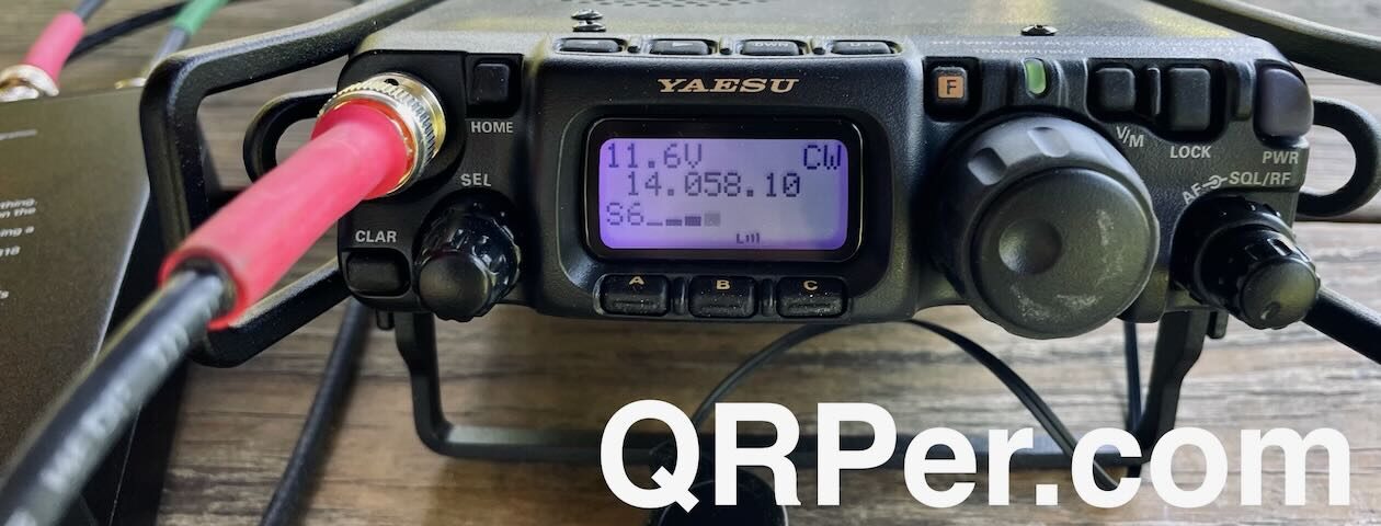
OK, now that we have reached “a destination” it’s time to set up my shack-in-a-pack I’ll be operating with my KX2 at 7 or 8 watts and the KX2 internal battery and one extra KX2 backup battery. I’m also using the KXPD2 paddle. My KX2 also has the Elecraft built-in ATU antenna tuner which allows me to operate across all the upper HF bands. Until recently, most of my activations were using 30m or 20m center-fed dipoles (operated flat or inverted-V) made by N9SAB (excellent portable dipoles). While very efficient, dipoles do take extra time and space to set up and take down.

However, I recently I came up with the idea of building and using a “Coaxial-Sleeve Dipole” as you’ve read about in my prior article. Typically, sleeved dipoles are oriented vertically. Ironically, while a coaxial-sleeve dipole appears end-fed, electrically, it functions as a center-fed dipole, but usually oriented vertically. My home VHF 2M antenna is a homebrew vertical-sleeve dipole made of copper pipe. It works quite well so I wanted to try this concept on POTA HF to make my antenna setup a little simpler.
Mine is cut for 20m band but tunes wonderfully on all HF bands with the aid of Elecraft ATU available for the KX2 and KX3 transceivers if you purchased them with the ATU. I haven’t documented my construction details. This is still experimental for me. I explained a little bit more about this antenna in my previous field reports on QRPer.com. If you are curious about this coaxial-sleeve dipole antenna, there is some generic information on the Internet.

I used my trusty Weaver 8 oz arborist throw bag and line to hoist the end of the vertical dipole up the nearest suitable tree that is near my operating area. I got the bag over the tip of the tree which is only about 23 ft. high. As my 20m dipole is about 32 ft. long, it was necessary to slope it at about a 30° or 40° degree angle towards the SE – which is kind of optimal for my propagation to the preferred SE direction.
I love the Elecraft built-in antenna tuners. It allows me to tune this antenna from 30m -10m bands with a very good SWR match. It’s hard to actually see the RG-174 coaxial-sleeve dipole in this photo due to its black color and small size.

This may sound odd, but I typically orient my operating position to face the direction of my intended optimal propagation, which is often the direction of best views, too. I often pack with two Helinox speed stools, one to sit on and one to set the radio and log on. These stools are very lightweight and quick and easy to set up and pack away. They are a bit low to the ground, but it beats sitting on the ground.

Ok, time to start activating the Trout Creek Ecological Reserve CA-4221. It’s about 11:30 AM PST and I’m almost 1.5 hours late starting my scheduled activation.

In the meantime, Alexis is taking a snooze in the shade while I operate.

Typically, I start on 20m CW to get at least my first 10 contacts made. Once that goal is achieved, I move on to 17, 15, 12, and 10m CW. As always, mid-day 20m is the most active.

It took me about an hour to get 14 contacts on 20m. This included 10 states from California to New York and Florida, as well as Quebec and Ontario in Canada. So, I’m getting decent East and SE propagation. Next, I move onto 17m where I get 5 contacts before it goes dead. This includes 2 in MO, one in VA, and one in PA. And, one in Salamanca, SPAIN (EA1AF) !
Then I move onto 15m. Just two contacts: TN and NC. 12m and 10m bands were absolutely dead. The reverse beacons couldn’t even hear me. So, back down to 17m. Where I picked up five more contacts, including KY, VA, TX, VA, and ON.
I rarely try 30m band during the day anymore because it is usually dead, but I thought I would give it a try. Just one contact, and it was N4RKK in Florida. But that was it for 30m. Dead after that (or nobody listening).
Two more contacts on 20m: AR and IL.
Back to 17m. Six more contacts there: WI, NY, NC, IL, AZ, and MO.
Ok, time to try 15m one last time.
Voila, six contacts here: NC, WV, MA, KY, and TX.
12 and 10m bands are still dead.

All in all, I had a pretty good day activating. But it didn’t all come easy. In total, I spent about 5 hours operating. For me, I find it just takes persistence – continuing to call CQ and trying different bands when one goes dead. And, if I’m going to go through all the work to get up here, I’m determined to make it worthwhile.
In total, I had 41 CW contacts. Not a bad days work.

Tip: Click on images to enlarge views
As well, it was absolutely beautiful up here. We didn’t really want to leave. It is so peaceful and quiet up here out in the boonies, except for me making a CW racket. Not a soul around except for maybe a bear or two peeping through the bushes.
With all that said, it’s time to pack up and head back. We decided not to go back the way we came up – too dangerous on that cliffy scree slope. After studying the GPS and Google satellite views of the area, we decided to descend in the opposite direction from which we came. Slightly less treacherous but still steep slopes.
Only a short distance from our start, we come across more evidence that the bears aren’t far away. We don’t worry too much about them – we just make lots of noise as we trek along. I don’t think bears want to encounter people any more than we want to encounter them.

The trip back wasn’t uneventful, though. I did take a couple of tumbles on the slippery slopes. I didn’t realize it until we got back to the Subaru Forester, that I had picked up a couple of cactus heads when I fell. While back at the car I was brushing off some dirt from the back of my pants and Ouch! cactus needles pierced my fingers. Not a pleasant experience pulling it out.

My Equipment List:
Elecraft KX2
Elecraft Internal KXAT2 Automatic Antenna Tuner
Elecraft KXPD2 Paddle
Homebrew ½ wave “Vertical Coaxial-Sleeve Dipole”
Weaver 8 oz throw bag
GM CLIMBING Throw Line 1.7mm, 180 Ft Roll High Strength – Arborist Outdoor Utility Cord
West Coast Paracord Plastic Ladder Winder Cord Storage- Organizers (Blue, 20 Pack)
PARACORD PLANET 95 Type Paracord, Variety of Colors, 100 ft
5.11 Rush 72 Tactical backpack, military grade
Helinox Speed Stools
Garmin 66sr GPS
Counter Assault Bear Spray, purchased via Margo Supplies, Canada or USA.
Bear Spray Hip Holster, Margo Supplies, Canada or USA
All in all, it was a worthwhile and memorable day for Alexis and me.
Thanks for reading about our adventures.
Cheers/73, Jeff (VE7EFF) and Alexis (VE7LXE)
Thanks for posting your trip and congratulations on the successful activation. Beautiful pictures. Looks like you were well equipped, and your story was a good encouragement to older hams to get out there and hike. Glad the bears left you alone – it’s scary to not be the apex predator in an area.
Thanks, Steve. It’s amazing what we can accomplish once we put our minds to it. I don’t do these kinds of activities very much any more; but I love doing these kinds of day-trip outback adventures.
Jeff (VE7EFF)
Now we have visual proof of what the Bears do in the woods…
73, Kevin K3OX
The proof is in the pudding 😊
Nothing like the neighbours dropping hints …
Jeff (VE7EFF)
Great write up, Jeff. I have got to try that coaxial sleeve vertical. Need to get some 174 and a toriod.
W0HL
👍
I found the RG-174 center wire quite delicate to work with because it is so small. I’m considering an RG-58 version to try but don’t have any RG-58 right now. For my car-side activations, I actually used RG-8X to construct the coaxial-sleeve dipole. RG-58 may be a good middle-ground, if not too heavy for portable ops.
Jeff (VE7EFF)