You might recall that I’ve been testing a new backpack that I plan to use primarily for SOTA activations. It’s the Spec-Ops Brand T.H.E. Pack EDC.
I’ve now taken it on a few activations, but the very first outing was on Monday, December 7, 2021.
That afternoon, my daughters attended an afternoon art class that was only four miles from our QTH as the crow flies, but took 45+ minutes to drive. Gotta love the mountains!
I had no complaints whatsoever about the drive, though, because it was within five minutes of the Zebulon Vance Historic Birthplace; one of my favorite local POTA spots!
Zebulon B. Vance Birthplace (K-6856)
After dropping off the girls, I drove to Vance and was happy to see that no one was occupying their one picnic shelter. Even though the Vance site is relatively spacious and they’ve numerous trees along the periphery of the property, it’s a historic/archaeological site and as a rule of thumb I only set up at picnic areas in parks like these.
It was a breezy day and temps were hovering around 44F/7C. These are ideal conditions in my world.
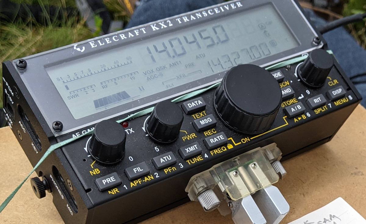
I grabbed the Discovery TX-500 for this activation. I had been using it quite a bit in the shack, but realized I hadn’t taken it to the field in a few weeks. I decided to pair it with the Chameleon MPAS Lite vertical antenna since I had already loaded the Lite in my pack, using the pack’s built-in antenna port. Continue reading Field Report: Pairing the Discovery TX-500, Elecraft T1, and CHA MPAS Lite→
[…]A random note on the Chameleon MPAS lite that I purchased a month ago through DX Engineering; I was surprised to find that the matching unit I received was white – it’s always pictured as black on the Chameleon shop page.
Note the black matching unit to the right of the counterpoise winder.
I was a bit disappointed at first; the “stealthiness” of the black colour was something I was hoping for. It also had me wondering if perhaps I’d somehow gotten a test-unit.
[…]I was curious about the colour change and shot Chameleon a note.
Here’s what they came back with:
“Phillip, due to the black Delrin being much more in demand and causing supply chain issues, we opted to switch to the less commonly used white material. The two colors have the same specifications, and should perform identically, besides the color. The issue being more noticeable for some was anticipated, but could not be helped if we were to continue production. Hit it with some flat spray paint?”
I will add that I do like this antenna a lot and the build quality is excellent. I’ve also come around on the colour; I like to think of the white version as a Canadian-Winter Edition.
[A]ll the best,
-p
ve3omi
It does look like an antenna ready for deployment with the Arctic Forces! 🙂
Thank you for sharing this, Phillip. I had seen a few photos of the white matching unit but assumed it was a different size or configuration than the one I have. This explains it.
I’m not sure if I’d have a preference for one or the other, frankly. If it was being used in a semi-permanent stealthy installation and in an area without snow, I’m sure painting it flat black or wrapping it with a dark color fabric/tape would help.
As you likely know, my activation reports typically run a few weeks behind. Although I’ve got several in the pipeline, I pushed the following report to the front of the line.
You might brew a cuppa’ coffee or tea for this one.
Here’s wishing you and yours very Happy Holidays and Merry Christmas!
73,
Thomas (K4SWL)
A Special Holiday Activation
As mentioned in my previous activation report, we’ve spent the past week on the Outer Banks of North Carolina; specifically, Hatteras Island.
It’s been amazing.
If you’re not familiar, the Outer Banks (OBX) is a 200-mile (320 km) long string of barrier islands off the coast of North Carolina and southeastern Virginia that separates the Pamlico Sound, Albemarle Sound, and Currituck Sound from the Atlantic Ocean.
No trip to the Outer Banks would be complete without visiting North Carolina’s most iconic structure: the Cape Hatteras Light Stationin Buxton, NC.
Cape Hatteras Lighthouse
On Thursday (December 16, 2021–last week) the weather was stunning, so my family took a few long walks on the beach, explored Hatteras Island, and spent the afternoon at the Cape Hatteras Light Station which is located within the Cape Hatteras National Seashore.
Last week, my family hopped in the car and took an eight hour drive to the Outer Banks of North Carolina.
We’ve had such a busy 2021 that we decided to take a full week prior to Christmas and fit in some proper vacation and family time.
We love going to the coast off-season to avoid big crowds. Turns out, we chose well, too: it’s as is we have the whole of the Outer Banks to ourselves. Other than a couple days with some “invigorating” weather (which we actually enjoy) it’s been absolutely spectacular.
The view from our cottage
While radio plays an important role in any travels, my family time always takes priority. The good thing about activating parks is that radio and family time often go very well together!
On Friday, December 17, 2021, my daughter Geneva (K4TLI) and I decided to spend the day together while my wife and other daughter worked on an art project at our rental cottage. We had a few loose plans, but mainly wanted to fit in a nice beach walk, possibly discover some new scenic spots, and enjoy a take-out lunch together.
She very much liked the idea of fitting in a bit of POTA, so we hit the field with two sites in mind.
The plan
My Subaru is still in the body shop getting repaired after a bear decided to open the doors and make himself at home, so we have a Toyota Camry rental car on this trip. It’s been a great vehicle for sure, but its trunk space is limited and we packed quite a lot of food knowing local restaurants would be closed this time of year.
We all limited our luggage and I limited the amount of radios and gear I took. I could write an entire article about my holiday radio and antenna selection process (seriously, I put too much thought into it) but in a nutshell I limited myself to two radios and two antennas.
On Monday, October, 18, 2021, I finished a few errands in Asheville, NC and realized I had just enough time to squeeze in an afternoon activation. The weather was beautiful, the fall air felt amazing, and although I had no clue what propagation was like, I needed some field radio therapy!
Blue Ridge Parkway to the rescue!
I’ve mentioned in previous videos that pretty much anytime I drive into Asheville I pass by the Blue Ridge Parkway. Over the years, I’ve discovered numerous POTA (Parks On The Air) spots scattered along “America’s Favorite Drive.”
It’s fall, so we’ve autumn leaf colors and loads of tourists in the region–especially on the BRP.
Even so, I’ve one favorite overlook that is often overlooked by tourist!
It’s a little unofficial turn-out on the parkway that offers up spectacular views. I believe the reason tourists pass by it is because it’s located just beyond one of the most popular overlooks in the area: the Tanbark Ridge Overview. Tourists stop at Tanbark to enjoy the views not knowing that a mere +/-200 meters away, there’s one they could enjoy all on their own. Continue reading Field Report: POTA Roadside activation with a view!→
On the morning of Thursday, September 23, 2021, I had one thing on my mind: SOTA!
It had been well over a month since my last SOTA activation and I was eager to hike to a summit and play radio.
It had been raining for a few days but overnight, a front moved into the area that swept out all of the clouds. We were finally feeling proper fall weather.
It was gorgeous outside and I made up my mind I’d fit in a summit activation.
I was visiting my parents in Hickory, NC, so I knew I’d have to drive a bit to activate a unique (to me) summit. On top of that, I knew I’d be alone and trails would be very muddy after days of rain. I decided to stick with an easy hike, so picked Flat Top Mountain (W4C/EM-026) off of the Blue Ridge Parkway.
I announced my activation via the SOTA website and drove about one hour to the trailhead of Flat Top Mountain.
Aborted!
As I drove up US321 to Blowing Rock I noticed that clouds were hangin over the mountains. In the foothills, it was blissful: clear skies, sunshine, dry air, and quite cool. As I drove up the Blue Ridge escarpment, it started getting a little gusty outside–I realized that the mountains were still on the edge of the cold front. Continue reading SOTA Plan B: An aborted activation followed by an amazing (although gusty) alternative!→
After completing a successful activation at Fort Dobbs State Historic Site on Wednesday, August 25, 2021, I decided to fit in one more activation that day. I thought about heading out to one of the game lands I hadn’t hit in a while, but frankly, I needed a park a little closer to home due to my time constraints that day, so Lake Norman State Park it was!
Lake Norman State Park (K-2740)
Lake Norman is such an effortless park to activate. Their main picnic area has numerous tables (including two large covered areas), and tall trees providing support for antennas and much needed shade from the NC summer sun!
One thing I had not decided upon was what antenna I’d use at Lake Norman. Earlier, I used my trusty speaker wire antenna at Fort Dobbs, but I like to shake things up. I checked the trunk of my car and found the Chameleon MPAS Lite. Seeing how propagation plummeted after my previous activation, I decided that I wanted a large wire antenna deployed rather than a vertical.
The MPAS Lite can be configured as a wire antenna, of course: instead of attaching the 17′ whip to the “Hybrid Micro” transformer, you attach the 60′ wire that might normally be used as a counterpoise.
Setting it up was quite easy, in fact. I used my arborist throw line to snag a tree branch about 45′ high, then attached the throw line to the floating dielectric ring on the Chameleon wire spool. I stretched the entire length of wire out, attached the end to a tree, then hoisted up the center, forming an inverted vee shape.
Wire antennas are so low-profile and simply disappear in trees.
Even thought the 50′ coax shield would act as a counterpoise, I really wanted another ground wire attached, so I pulled one of the wires off of my speaker wire antenna and attached it to the grounding post of the MPAS Lite’s stainless spike. I figured a little extra counterpoise wouldn’t hurt.
Although I’d never used the CHA MPAS Lite quite like this, I was pretty confident my Elecraft T1 would find a match. The Chameleon transformer (the Hybrid Micro) brings most any (but not all) lengths of wire within reasonable matching range of an ATU.
I started on 40 meters and found that, without employing the ATU, I had a match that was slightly below 2:1. Not terribly surprising since I had a good 60′ of wire in the tree. Still, I hit the tune button on the T1 and easily achieved a 1:1 match.
I will add here, though, that perfect 1:1 matches are not that important–especially at QRP levels. I’m certain the TX-500 would plug along with a match of 2.5:1 or higher and still radiate perfectly fine. I’ve known hams that truly equate that 1:1 match with an antenna that’s performing efficiently, but that’s not always the case. Keep in mind a dummy load will give you a 1:1 match but is hardly efficient. The ATU’s job isn’t to make the antenna radiate better–it’s to match impedance.
The CHA MPAS Lite will get you within matching range across the HF bands and, many times, it’s close enough that an ATU isn’t really needed.
I started calling CQ POTA on 40 meters and within 28 minutes had logged the ten contacts needed for a valid park activation–all with 5 watts, of course. I was very pleased with these results because, as I had suspected, the bands were still pretty darn rough.
I then moved up to the 30 meter band where I worked a couple of stations and then, for fun, found a match on 80 meters and worked one NC station (possibly on ground wave!).
Here’s a screenshot of my logs from the POTA website:
I must say that I do love using the Discovery TX-500. It’s such a brilliant little field radio. I’m just itching to take it on another SOTA activation soon!
I’m also loving the TX-500 field kit that I built around a Red Oxx Micro Manager pack.
I used the same bag (different color) for my KX2 NPOTA field kit in 2016. It’s such a great size and can even easily hold my arborist throw line along with all of the station accessories and rig, of course. I’ve made a short video showing how I pack it and will upload that video when I have a little bandwidth!
Video
I did make a real-time, no-edit video of my entire Lake Norman activation. Feel free to check it out below or via this YouTube link. No need to worry about ads popping up–my videos have no YouTube ads!
A Brief Public Service Announcement…
If I have a little advice for you this week, it’s this: don’t wait to play radio because someone says you don’t have the right gear for the job.
I received an email this morning from a ham that’s new to field operation and just received an antenna he had ordered. He was upset because a YouTuber claimed his antenna was basically a dummy load. To add insult to injury, he also found a blogger or YouTuber was also highly critical of his recently-acquired Yaesu FT-818. [Note that the FT-817ND–the 818’s predecessor–is one of my favorite field rigs.]
Keep in mind that many of these YouTubers are trying to produce “click bait” videos that will stir up a reaction and, thus, increase their readership numbers which will have a direct and positive impact on their ad revenue. It’s a red flag when someone doesn’t have real-world examples and comparisons proving their points and typically a sign that they’ve never even used the products in question.
I’ve been told antennas I use don’t work, yet I’ve snagged some incredible QRP DX with them. I’ve been told that some radios I use are junk, yet I’ve hundreds of successful field activations with them. And funniest of all are those who tell me that QRP is ineffective and–quoting from an actual message recently–“a complete waste of time.”
My advice is to simply ignore these folks. The proof is in the pudding! Get out there and play radio! In the words of Admiral Farragut, “Damn the torpedoes. Full speed ahead!” 🙂
Thank you!
As always, thank you for reading this field report and a special thanks to those of you who are supporting the site and channel through Patreon and the Coffee Fund. While certainly not a requirement–my content is always free–I really appreciate the support.
Two weeks ago, my buddy Monty and I went on a camping trip near Mount Pisgah off of the Blue Ridge Parkway. It was amazing.
Monty is one of my best friends and like a brother to me. We were roommates during my undergraduate years at Western Carolina University. In those days, we were both into mountain biking, hiking, trail running, backpacking, and camping. WCU was the perfect launching point for all of those activities.
These days, we both still do hiking and a little mountain biking, but at–what we might generously call–a more “relaxed” pace.
Although Monty’s family also live in western North Carolina and we keep in touch pretty regularly, we hadn’t seen each other in person for years, so we knew a camping trip would sort all of that out and give us a chance to reconnect while disconnecting from our busy schedules.
Mount Pisgah
You can’t see it in the photo, but my 25 year old four person dome tent about pushed Monty’s two person dome tent off of the camping pad! And, yes, I brought a butane torch to light the campfire–not exactly bushcraft.
We chose Mount Pisgah campground off of the Blue Ridge parkway for a few reasons: it’s roughly halfway between our homes, it’s at a high altitude which equates to cooler nights during the hottest part of the summer, and–you guessed it–it’s on no less than two POTA sites and close to a number of SOTA summits as well!
Another fun fact about the Mount Pisgah campground? It’s also black bear habitat. I believe I mentioned that when I activated Mount Pisgah earlier this summer, I spotted a number of bears in this area. But hey! Check out the park’s bear traps:
And to be honest? My QTH is also just as much in black bear territory, so this isn’t exactly unfamiliar.
Richland Balsam (W4C/WM-003)
I was up earlier than Monty, so I brewed some coffee, read a bit of my book, and fit in a little early morning POTA!
The weather was ideal on the morning of Monday, August 2, 2021.
Monty actually mentioned in advance that he’d like to accompany me on a SOTA activation or two. He’s an engineer at WCU and I’ve been nudging him for years to get his ham ticket, so how in the world could I pass up a little SOTA/POTA proselytizing?
While Monty cooked up some breakfast burritos, we hatched a plan to activate Richland Balsam first.
Richland Balsam is a very accessible 6,410′ (1954M) summit and is actually the highest peak on the entire Blue Ridge Parkway.
Richland Balsam is a great “beginners” SOTA summit because the loop trail is only 1.5 miles long, well-marked, doesn’t require an experienced hiker, and passes through a spruce-fir forest which not only provides shade, but also ample trees for wire antennas. The trailhead is easy to find as well; it’s at the north end of the Haywood/Jackson overlook parking area.
Only one word of caution: being such an accessible loop trail right there on the Blue Ridge Parkway, it can get very busy during the summer and fall–in fact, you might struggle to find a spot to park. Monty and I arrived early enough that there were only a handful of cars parked at the overlook.
Richland Balsam reminds me of some of the trails in/around Mount Mitchell: lots of ferns, mosses, and and the smell of spruce-fir. Bliss!
On The Air
I’d forgotten that there are actually a couple of benches on the summit of Richland Balsam which is a proper luxury for any SOTA activator!
Monty had no issue at all setting up the Chameleon MPAS Lite vertical on his own as I prepared my clipboard, Elecraft KX2, and log book.
I actually had decent mobile phone service on the summit, so spotting myself was quite easy via the SOTA Goat app. Of course, I assumed I might not have access to spot myself, so I did schedule the activation before leaving the campsite on both the SOTA and POTA platforms knowing both would auto-spot me from the Reverse Beacon Network (RBN).
I started calling CQ on 20 meters CW and my first contact was fellow POTA activator Steve (KC5F) who was, no doubt, working me via ground wave from his home. Always good to have Steve in the logs.
In thirteen minutes, I worked nine stations on 20 meters–lots of familiar calls. I actually validated the SOTA activation (logging four contacts) in no less than five minutes!
I then moved to 17 meters where I worked K6MW in Washington state.
Finally, I moved down to the 40 meter band in hopes of picking up Mike (K8RAT)–success!–and also worked good ole’ Bill (WB1LLY) in Georgia.
Here’s my full log sheet:
Near the end of the activation (you might note this in the video), Monty and I hear a loud animal noise in the forest–very likely a black bear making itself known. We took that as a cue to pack up and move on.
Video
Here’s my real-time, real-life, no-edit video of the entire activation from start to finish. If you’ve been seeking a cure for insomnia, you’ve found it:
After leaving Richland Balsam, we decided to also take in W4C/CM-005 (Black Balsam Knob) which is another 10 point summit on the Blue Ridge Parkway. I tried making a video of this activation, but for some reason the camera shut down after nine minutes. I’m uncertain yet if I’ll publish that video with a post. We’ll see! It, too, was a fun activation.
After Black Balsam, Monty and I prepared a late lunch back at the campsite and decided that there was still enough of the day left to take in the Mount Pisgah summit trail. Frankly, it was simply too tempting! There was a trail not even 25 feet from our tents which lead us to the Mount Pisgah trailhead. Since I had already activated Mount Pisgah only recently, I didn’t take radio gear this time.
Turk’s-cap lilies were in bloom along the Mount Pisgah trail.
Funny, but we both underestimated the hike from our campsite to the Mount Pisgah trailhead. In my head, I assumed it was perhaps half a mile or so. Turns out, it was more like 1.5 miles one way!
The Mount Pisgah tower
Combined with the actual Mount Pisgah trail, it made for a decent amount of hiking. I believe we left the campsite around 16:00 local and were back by 19:00 or so.
That Monday turned out to be a day full of hiking, radio, and hanging with Monty. It was amazing fun.
Thank you
As always, thank you for reading this report and thank you to those who are supporting the site and channel through Patreon and the Coffee Fund. While certainly not a requirement–my content is always free–I really appreciate the support.
Here’s wishing everyone good health and maybe even a little outdoor radio fun this week!
I’ve been receiving a lot of comments lately from readers and viewers asking to see more Hazel in my reports and videos.
Hazel, if you’re not familiar, is my brown, white, and freckled canine shadow.
Hazel requires absolutely no prep time to go on a hike and summit/park activation. She’ll go from a deep, dreamy sleep where she’s chasing squirrels and her paws are twitching, to wide awake, tail wagging and nose pointed at the door in 2 seconds flat.
All it takes is the sound of me putting on my hiking boots (which must be louder that I imagined).
On Monday (May, 24, 2021) the weather was beautiful and I decided to finally add Bearwallow Mountain to my list of SOTA activations. Hazel was ready for a short hike!
Bearwallow Mountain (W4C/CM-068)
Bearwallow is one of the most popular summits to activate in the Asheville/Hendersonville area of western North Carolina. Any semi-seasoned local SOTA activator probably has Bearwallow in the logs. Why?
The Bearwallow antenna farm is extensive!
For one thing, Bearwallow is a ham-friendly site. A number of local repeaters are on this mountain and some of our local clubs have access to the summit. Once–I can’t remember the year–I even spent time with a club (I believe it was the Roadshow ARC) on Bearwallow for the ARRL Field Day. It was a blast!
Bearwallow is also a very accessible summit.
The trailhead to the summit (Google Map) is tucked away in the Upper Hickory Nut Gorge area–and there’s ample paved parking unless you happen to pick a very busy day (basically, any weekend with good weather will be busy!). Hazel and I were hiking on a Monday morning, thus there was very little activity and loads of parking spaces.
Some years ago, Conserving Carolina acquired the summit and much of the land on Bearwallow Mountain. Their conservation easement protects this area from future development and opens it for the public to enjoy.
Conserving Carolina maintains the trail system to the summit and all of the hiker information and blazing.They do a brilliant job!
There are two options for hiking to the summit: a proper foot trail, or you can take the Fire Tower Road which is the best choice for hikers who need a more gentle incline and flat gravel hiking surface.
Hazel and I found a nice spot to set up the station well within the activation zone. On summits like Bearwallow where there are clusters of communications towers, I prefer not to set up next to them. This is where that 25 meter SOTA activation zone (AZ) comes in handy.
I had actually planned to use my Elecraft KX3 on this activation, but after setting it up, I realized quickly that my power cord had developed a fault.
Fortunately, I packed a spare radio.
Knowing in advance that this would be a short hike–before leaving the QTH–I also packed the KX2 kit in my backpack as a backup. I don’t always have the luxury of packing a second radio, but wow! Am I glad I did that Monday!
Setting up the Chameleon CHA MPAS Lite vertical, of course, was super easy.
On the Air
I started the activation on 20 meters and spotted myself to the SOTA network via the SOTA Goat app. Of course, before leaving home, I had also set up an alert on SOTAwatch so that the spots page would auto-spot me via the Reverse Beacon Network (RBN) if I didn’t have mobile phone coverage.
In short? The contacts started rolling in. I was very surprised to have this sort of response on a Monday morning.
In 22 minutes, I worked a total of 19 stations including one summit to summit (S2S)–thanks for that, Eric (VA2EO)!
I was very pleased with the number of contacts logged in such short order because I only had a max of 25-30 minutes to be on the air before I needed to pack up and head back to the QTH.
Here’s the full log:
Activations like this one remind me of what one can do with QRP power and a modest antenna.
Sure, at one point–after I had worked at least my first four to achieve a valid QRP SOTA activation–I increased the power from 5 watts to a cloud-scorching 10 watts! 🙂
I must apologize for the audio in this one–it’s a little weak due to how the camera was set up.
Hazel at it again
So I brought along a retractable leash/lead for Hazel for this particular outing.
This leash allows her to roam more freely during our actual hike. On the summit, I locked the leash and attached it to my pack so it would keep her within 4 feet or so of where I was sitting which was cow patty-free.
At one point, near the end of the activation, when I was trying to manage a few calls, off-camera Hazel discovered that the leash unlocked, allowing her more flexibility to roam.
I looked up to discover that she found a semi-moist cow patty I somehow missed and was preparing to “enjoy” it. While sending CW and trying to keep from knocking down the camera, I used my left foot to put the brakes on her leash. She knew I was struggling, though, and tugged more.
I managed to stop her before even one paw plopped in the patty. Somehow. It was a very close call, though.
If you’ve watched my activation videos before, you’ve no doubt gathered that I’m not a multitasker. This little event really tested my ability to hold it all together on and off camera! 🙂
After packing up the station, Hazel and I took the Fire Tower Road back to the car. It was a very pleasant stroll and cow patty free.
Thank you for coming along with me on this SOTA activation and making it to the end of the report. You deserve an award! Please treat yourself to a local summit or park soon!
Last Tuesday (April 20, 2021), I decided to make a detour to a park I had never visited before: Crowders Mountain State Park (K-2726).
It’s actually quite odd that I’ve never activated this park during the weekly trip to do a little caregiving for my folks: Crowder’s Mountain State Park is a reasonable detour especially compared to some of the more remote parks I’ve visited recently.
What’s really impressive about Crowders Mountain is that although it’s not as large as a national park and it’s very close to the city of Gastonia, it has no less than two unique summits that qualify for Summits On The Air: The Pinnacle and Crowders Mountain.
Both summits are accessible from the main park visitors’ center via a well-maintained trail network.
The propagation forecast looked pretty grim and after my last activation, I thought I might increase my chances of success by hiking to both summits in one visit. This made sense because I would only need 4 contacts per summit to have a valid SOTA activation and I could combine the contacts from each summit to hit 10 total contacts to activate the state park.
I decided to call the park and ask how long it would take to hike to both summits: the ranger told me “about 5 hours, or less if you’re fast.” That meant that once I added in my setup/pack up times and on-the-air time, I would be staring at a minimum of 7-8 total hours.
I (wisely) decided to pass on that opportunity. I simply didn’t have enough time in my schedule for that many hours at the park. That, and I didn’t want to feel rushed–I wanted to enjoy my outdoor time.
I decided instead to activate one summit and simply plan on spending more time on the air then plan to come back to the park for the second summit on a different day.
Before going to bed Monday night, I checked out the trail map and decided to activate The Pinnacle.
Crowders Mountain State Park (K-2726)
I arrived at Crowders Mountain State Park around 11:00 AM local–the weather was nearly ideal.
I had pre-packed all of the radio gear and supplies in my GoRuck GR1 rucksack, so once I arrived, I grabbed the pack, put on my hiking boots, a hat, and hit the trail.
I’ve read that Crowders Mountain State Park can get very busy and it’s no surprise as the park is within easy reach of Shelby, Gastonia, and the Charlotte Metro area. Fortunately, I was visiting on a Tuesday morning, and while I saw at least 30+ cars parked in the main parking lot, I passed other hikers only a few times on the Pinnacle trail. It’s a sizable park and can easily swallow 30 groups of day hikers!
I followed the orange-blazed trail to the summit of The Pinnacle.
The hike was very enjoyable and, frankly, not what I would consider strenuous, but it had enough elevation change to feel like a proper hike. I allowed an hour to reach the summit, but it only took about 40 minutes or less.
Near the summit, there’s a fork in the trail: if you take a right, it leads to the summit, if you take a left, it’ll lead you on a much longer Ridgeline Trail that will eventually take you into Kings Mountain State/National Park–you’d better believe I’ll try that one day in the future! It would be fun to activate two parks and a summit all on foot.
I took a right at the fork and the .2 mile long trail zig-zagged up the side of The Pinnacle.
I was a little surprised to be greeted by the sign above. It’s true that the summit area is quite rocky and you have to watch your step, but this warning is a bit extreme in my opinion (especially since the SOTA activation I did with my daughter recently was orders of magnitude more dodgy!).
If you are activating The Pinnacle and don’t want to climb up the rocky path, no worries. I’m certain the area where the sign is located is well within the SOTA summit activation zone.
The Pinnacle (W4C/WP-010)
Although The Pinnacle is only a “one point” summit, when you reach the top you’re greeted by some impressive views.
The Pinnacle and Crowders Mountain are both outlying mountains so are the tallest points in the area offering beautiful, long-range vistas.
There were perhaps a half dozen hikers hanging out on the summit. I found a quite spot to set up on the side of the summit only a few meters from the top.
During the hike, my buddy Mike (K8RAT) sent a text noting that propagation on 40 meters was non existent. He suggested I play on 20 meters and above, possibly including 30 meters.
Later on, I found out that Mike was 100% correct. Several POTA activators that day mentioned on the POTA Facebook group that 40 meters was completely wiped-out.
I installed the Chameleon MPAS Lite vertical antenna next to me. I’ll admit that I was a little worried it might be too rocky to plunge the MPAS Lite’s stainless spike in the ground, but it turned out not to be the case.
The CHA MPAS Lite has really proven itself as an invaluable SOTA antenna. While the stainless spike adds weight to my pack, it’s less fussy than dealing with guy lines and telescoping fiberglass poles and much quicker to set up. You do need enough ground to plunge that spike into, but if there are trees and bushes on the summit, it’s probably doable!
I started recording a video (see below) of the activation, spotted myself to the SOTA network (even though it would have likely auto-spotted me via the Reverse Beacon Network) and hopped on 20 meters.
Solar Flare!
I had no idea at the time, but we were experiencing a solar flare which explained why 40 meters was completely wiped out.
The effect on 20 meters was simply epic.
I called CQ and was instantly rewarded with a long, continuous string of stations. Within 26 minutes, I had already worked 23 stations with 5 watts and the MPAS Lite vertical. A stark contrast to my previous POTA activation.
The view from my shack
And here’s the thing: the flare opened up 20 meters to local/regional stations as well. I worked stations as close as South Carolina, Georgia, and Tennessee–this is simply unheard of normally. Of course, stations on the west coast were also booming in.
I was a little surprised I didn’t log any European stations on 20 meters, but I suspect they were having a difficult time competing with the strong signals from North America during the flare.
I short: the band opening was amazing fun and even renewed my faith in our local star just a wee bit. (Ha ha!)
After playing on 20 meters, I decided to try 17 meters.
Wow! Without a doubt, I worked more stations on 17 meters in short order than I’ve ever worked during a field activation. In 10 minutes, I worked 12 stations. As with 20 meters, the flare opened up stations that would normally be in my 17 meter skip zone.
Here I was worried about logging the ten stations needed to validate my park activation! After logging 35 total contacts, I decided to pack up.
Here’s a QSO Map of the activation (click to enlarge):
Video
Here’s one of my unedited real-time, real-life videos of the entire activation:
Although the weather app on my phone wasn’t showing any afternoon thunderstorms nearby, there were some patchy dark clouds forming on the other side of the summit and the winds were shifting, so I decided to call it a day and enjoy the hike back down the mountain.
Fortunately, the clouds never amounted to anything but I don’t take my chances with spring weather–it’s fickle, especially along the North Carolina/South Carolina line. That, and frankly, I needed to stick to my travel schedule.
I took my time on the way back down and simply soaked up the outdoors.
I love doing field activations of all types, but I’ll admit that I’m becoming addicted to Summits On The Air because of the hiking opportunities it presents.
There are few things in the world I enjoy more than hiking.
When I’m on a trail, all of my concerns seem to dissolve.
Perspective
On the return hike, I passed by a group of three hikers. All of them were staring at their phones while hiking and one tripped on a tree root in the path. They caught themselves before hitting the ground.
I’ll admit I was thinking at the time that mother nature was saying, “Hey! Wake up, disconnect and enjoy the beauty around you! You need some perspective!” 🙂
I’m already looking forward to visiting Crowders Mountain State Park again. I believe I’ll return within a month and hike to Crowders Mountain, activating both the summit and park.
Sometime, I’d like to hit the trails as soon as the park opens and, perhaps, activate both Crowders Mountain and Kings Mountain parks on foot. That would likely take an entire day when I include the time on the air, but it would also be a lot of fun.
I was telling my wife yesterday that I actually enjoy writing up the odd field report on QRPer. It hit me that there are a couple of reasons why…
For one, a number of readers have reached out and thanked me because they enjoy living vicariously through my field reports and videos. I get it. My family and I enjoy watching YouTube videos of travelers around the world. We avoid the personality-driven channels and focus more on those that are less “produced.” It gives us an opportunity to travel to, say, Spain, France, Finland, or Turkey when we can’t presently do so. It pleases me to no end thinking that my reports and videos could, even in some very small way, offer a little vicarious travel to others.
Secondly, writing up these reports gives me an opportunity to re-experience some of my field time and sort through photos I might have taken along the way. Although it takes a few hours to write a report, I truly appreciate the experience.
Thank you, dear reader, for spending time with me during this outing!
QRP radios, product announcements, reviews, news and more. Low power amateur radio fun!
Please support QRPer by adding us to your whitelist in your ad blocker. Ads are what helps us stay online. All of our ads are ham radio related--no junk, we promise! Thank you!
 You might recall that I’ve been testing a new backpack that I plan to use primarily for SOTA activations. It’s the Spec-Ops Brand T.H.E. Pack EDC.
 After dropping off the girls, I drove to Vance and was happy to see that no one was occupying their one picnic shelter. Even though the Vance site is relatively spacious and they’ve numerous trees along the periphery of the property, it’s a historic/archaeological site and as a rule of thumb I only set up at picnic areas in parks like these.